Tulu is a Dravidian language whose speakers are concentrated in Dakshina Kannada and in the southern part of Udupi of Karnataka in south-western India and also in the northern parts of the Kasaragod district of Kerala. The native speakers of Tulu are referred to as Tuluva or Tulu people and the geographical area is unofficially called Tulu Nadu.

Kasaragod is a municipal town and administrative headquarters of Kasaragod district in the state of Kerala, India. Established in 1966, Kasaragod was the first municipal town in the district. It is the northernmost district of Kerala and is also known as Sapta Bhasha Sangama Bhumi.

Kanara or Canara, also known as Karavali, is the historically significant stretch of land situated by the southwestern coast of India, alongside the Arabian Sea in the present-day Indian state of Karnataka. The subregion comprises three civil districts, namely: Uttara Kannada, Udupi, and Dakshina Kannada. Kassergode was included prior to the States Reorganisation Act.

Dakshina Kannada district is located in the state of Karnataka in India, with its headquarters in the coastal city of Mangalore. It is part of the larger Tulu Nadu region. The district covers an area nestled in between the Western Ghats to its east and the Arabian Sea to its west. Dakshina Kannada receives abundant rainfall during the Indian monsoon. It is bordered by Udupi district to the north, Chikmagalur district to the northeast, Hassan district to the east, Kodagu to the southeast and Kasaragod district of Kerala to the south. According to the 2011 census of India, Dakshina Kannada district had a population of 2,083,625. It is the only district in Karnataka state to have all modes of transport like road, rail, water and air due to the presence of a major hub, Mangalore. This financial district is also known as the Cradle of Indian banking.

Tulu Nadu, or Tulunad, is a region and proposed state on the southwestern coast of India. The Tulu people, known as 'Tuluva', speakers of Tulu, a Dravidian language, are the preponderant ethnic group of this region. The proposed region, which once existed as the district South Canara, encompasses the undivided territory of the contemporary Dakshina Kannada and Udupi districts of Karnataka and Kasaragod district of Kerala.
South Canara was a district of the Madras Presidency of British India, located at 13.00°N 75.40°E. It comprised the towns of Kassergode and Udipi and adjacent villages, with the administration at Mangalore city. South Canara was one of the most heterogeneous areas of Madras Presidency, with Tulu, Malayalam, Kannada, Konkani, Marathi, Urdu, and Beary languages being spoken side by side. It was succeeded by the Tulu-speaking areas of Dakshina Kannada district, the Malayalam-speaking area of Kasaragod district and the Amindivi islands sub-division of the Laccadives, in the year 1956.

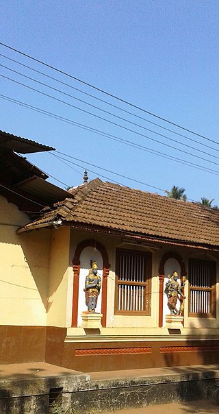
Belle is a village in the southern state of Karnataka, India. It is located in the Kaup taluk of Udupi district. The village is known for its historic Moodu-Belle Mahalingeshwara Temple dedicated to Shiva.

The Tulu people or Tuluvas are an ethno-linguistic and ethno-cultural group from Southern India. They are native speakers of the Tulu language and the region they traditionally inhabit is known as Tulu Nadu. This region comprises the districts of Dakshina Kannada and Udupi in Karnataka and part of Kasaragod district in Kerala, with Mangalore, Karnataka being the commercial hub. The Census report of 2011 reported a population of 1,846,427 native Tulu speakers living in India.
The Bunt people are an Indian community who historically have inhabited the Tulu Nadu region in South India. Bunts were traditionally a warrior-class or martial caste community, with agrarian origins, forming the landed gentry of the region. They are the dominant land-owning, farming and banking community of Tulu Nadu and speak Tulu and Kundagannada as their mother tongue. Today, the Bunts are a largely urbanised community, with a population size of less than one million worldwide.

Tigalari, also known as Tulu script, is a Southern Brahmic script which was used to write Tulu, Kannada, and Sanskrit languages. It was primarily used for writing Vedic texts in Sanskrit. It evolved from the Grantha script. It is referred to as Tigalari lipi in Kannada-speaking regions and Tulu speakers call it as Tulu lipi. It bears high similarity and relationship to its sister script Malayalam, which also evolved from the Grantha script.
The Alupa dynasty was an ancient ruling dynasty of India. The kingdom they ruled was known as Alvakheda Arusasira and its territory spanned the coastal districts of the modern Indian state known as Karnataka. The Alupas in their prime were an independent dynasty, centuries after reigning due to the dominance of Kadambas from Banavasi, they became feudatory to them. Later they became the vassals of the Chalukyas, Rashtrakutas, Hoysalas with the change in political scenario of Southern India. Their influence over coastal Karnataka lasted for about 1200 years. There is evidence that the Alupas followed the law of matrilineal inheritance (Appekatt/Aliyasantana) since the Alupa king Soyideva was succeeded by his nephew Kulasekhara Bankideva. The legendary king who is credited with introducing matrilineality in Alva Kheda|Tulu Vishaya Kheda is named Bhuta Alupa Pandya The descendants of this dynasty still survive to this date and have spread in the karavali region and they are widely referred to as the Bunt. The Bunts follow Matrilineality instead of the common Patrilineality, and are said to be Nagavanshi Kshatriyas by their maternal origin. They can be identified with their surnames such as Shetty, Rai, Hegde, Alva, Chowta etc. Even though most Bunt are Hindus by faith now, The sizeable section of the community still follows Jainism and they are called Jain Bunt The last Alupa king to have ruled is Kulasekharadeva Alupendradeva whose inscription dated 1444 CE have been found in Mudabidri Jain Basadi.

Paduru Gururaja Bhat was a teacher, historian and archaeologist of Tulu Nadu and of Barkur, the ancient capital of the Tulu kingdom.

Kasaragod is one of the 14 districts in the southern Indian state of Kerala. Its northern border Thalappady is located just 9 km south to Ullal, which is the southernmost portion of the major port city Mangalore, on the southwestern Malabar coast of India.
Mangaloreans are a collection of diverse ethnic groups that hail from the historical locales of South Canara (Tulunaad) on the south western coast of Karnataka, India, particularly the residents native to Mangaluru.

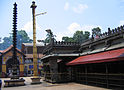
Karkala, also known as Karla in Tulu language, is a town and the headquarters of Karkala taluk in the Udupi district of Karnataka, India. Located about 60 km from Mangalore in the Tulu Nadu region of the state, it lies near the foothills of the Western Ghats. Karkala has a number of natural and historical landmarks, and is a major tourist and transit destination due to its strategic location along the way to Hebri, Sringeri, Kalasa, Horanadu, Udupi, Kollur, Subrahmanya and Dharmasthala.

Tulu Nadu State movement is aimed at increasing Tulu Nadu's influence and political power through the formation of separate Tulu Nadu state from Karnataka and Kerala. Tulu Nadu is a region on the south-western coast of India. It consists of the Dakshina Kannada and Udupi districts of Karnataka and Kasargod district up to the Chandragiri river in Kerala. The Chandragiri River has traditionally been considered a boundary between Tulu Nadu and Kerala from the fourth century AD onwards. The first call for a separate Tulu Nadu state was made just after the Quit India Movement in 1942 by Srinivas Updhyaya Paniyadi, a banker and a press owner from Udupi. Mangalore is the largest and the chief city of Tulu Nadu. Tulu activists have been demanding a separate Tulu Nadu state since the late 2000s, considering language and culture as the basis for their demand.
Karnataka is a state in the southern part of India. It was created on 1 November 1956, with the passing of the States Reorganisation Act. Karnataka is bordered by the Arabian Sea to the west, Goa to the north-west, Maharashtra to the north, Telangana and Andhra Pradesh to the east, Tamil Nadu to the south-east, and Kerala to the south-west. The state covers an area of 74,122 sq mi (191,976 km2), or 5.83% of the total geographical area of India. It comprises 30 districts. Kannada is the official language of Karnataka and as per the 2011 census is the mother tongue of 66.5% of the population. Various ethnic groups with origins in other parts of India have unique customs and use languages at home other than Kannada, adding to the cultural diversity of the state. Significant linguistic minorities in the state in 2011 included speakers of Urdu (10.8%), Telugu (5.8%), Tamil (3.5%), Marathi (3.4%), Hindi (3.2%), Tulu (2.6%), Konkani (1.3%) and Malayalam (1.3%).
Bantwal taluk is a taluk of Dakshina Kannada district. The headquarters is the town of Bantwal, an eastern suburb of Mangalore.
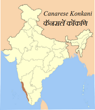
Canarese Konkani are a set of dialects spoken by minority Konkani people of the Canara sub-region of Karnataka, and also in Kassergode of Kerala that was part of South Canara.