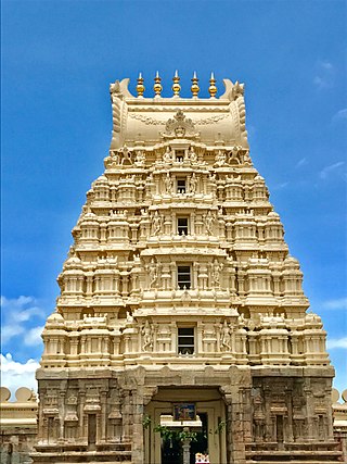
Srirangapatna is a town and headquarters of one of the seven Taluks of Mandya district, in the Indian State of Karnataka. It gets its name from the Ranganthaswamy temple consecrated around 984 CE. Later, under the British rule, the city was renamed to Seringapatam. Located near the city of Mandya, it is of religious, cultural and historic importance.

Kolar district is a district in the state of Karnataka, India.
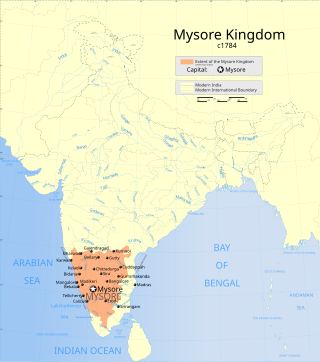
The Kingdom of Mysore was a geopolitical realm in southern India founded in around 1399 in the vicinity of the modern-day city of Mysore and prevailed until 1950. The territorial boundaries and the form of government transmuted substantially throughout the kingdom's lifetime. While originally a feudal vassal under the Vijayanagara Empire, it became a princely state in British India from 1799 to 1947, marked in-between by major political changes.

Mysore district, officially Mysuru district, is an administrative district located in the southern part of the state of Karnataka, India. It is the administrative headquarters of Mysore division. Chamarajanagar District was carved out of the original larger Mysore District in the year 1998. The district is bounded by Chamrajanagar district to the southeast, Mandya district to the east and northeast, Kerala state to the south, Kodagu district to the west, and Hassan district to the north.

Bengaluru is the capital city of the state of Karnataka. Bengaluru, as a city, was founded by Kempe Gowda I, who built a mud fort at the site in 1537. But the earliest evidence for the existence of a place called Bengaluru dates back to c. 890.

Devanahalli, also called "Devandahalli", "Dyaavandalli", Devanadoddi, and Devanapura, is a town and Town Municipal Council in Bengaluru Rural district in the state of Karnataka in India. The town is located 40 kilometres (25 mi) to the north-east of Bengaluru. Devanahalli is the site of Kempegowda International Airport. A multibillion-dollar Devanahalli Business Park with two IT Parks are coming up on nearly 400 acres (1.6 km2) adjoining the airport. An Aerospace Park, Science Park and a ₹10 billion (US$120 million) Financial City are also coming up. A new satellite ring road will connect the city with Doddaballapur. Devanahalli is situated near the upcoming ₹1,500 billion (US$18 billion), 12,000-acre (49 km2) BIAL IT Investment Region, to be the largest IT region in India.

Nandi Hills is an ancient hill station built by Ganga Dynasty in the Chikkaballapur district of Karnataka state. It is 10 km from Chickballapur town and approximately 60 km from Bengaluru. The hills are near the town Nandi. In traditional belief, the hills are the origin of the Arkavathy river, Ponnaiyar River, Palar River, Papagni River and Penna River. Watching the sunrise at Nandi Hills is popular with tourists. The first ever SAARC summit hosted by India was held at Nandi Hills in 1986.
Chikkaballapur is the district headquarters of the newly created Chikkaballapur district in the state of Karnataka, India, which was carved out from Kolar district. It is located within 3 km of Muddenahalli. A $400 million Pharmaceutical SEZ is coming up in Chikkaballapur on 325 acres (1.32 km2), the first of its kind in India. Furthermore, the noted Traveler Bunglow is being converted into a state-of-the-art bus terminus. A new district government headquarters and police headquarters is being constructed at a cost of $5 million. In addition, the state government is releasing over $10 million to develop the city and expand underground sanitary systems. It is a regional transport and educational hub, and is a major site for grape, grain, and silk cultivation"

Kolar or Kolara is a city in the Indian state of Karnataka. It is the headquarters of Kolar district. The city is known for its milk production and gold mines. It is also known for the Someshwara and Kolaramma temples.

Davanagere district is an administrative district of Karnataka state in India. It is the centre of Karnataka. The city of Davanagere is the district headquarters. It had a population of 1,643,494 of which 32.31% was urban as of 2011. This district was separated from Chitradurga district in 1997 by the then Chief minister of Karnataka J. H. Patel including Chennagiri and Honali Taluks Shimoga district.

Sadali is a hobli headquarters in Chikballapur district, Karnataka, India. It is located at a distance of about 100 km from Bangalore. It is equidistant from five taluk headquarters: Sidlaghatta, Chintamani, Bagepalli, Gudibanda and Chikballapur.

Nayakas of Keladi (1499–1763), also known as Nayakas of Bednore and Ikkeri Nayakas, were an Indian dynasty based in Keladi in present-day Shimoga district of Karnataka, India. They were an important ruling dynasty in post-medieval Karnataka. They initially ruled as a vassal of the famous Vijayanagar Empire. After the fall of the empire in 1565, they gained independence and ruled significant parts of Malnad region of the Western Ghats in present-day Karnataka, most areas in the coastal regions of Karnataka and the central plains along the Tungabhadra river. In 1763 AD, with their defeat to Hyder Ali, they were absorbed into the Kingdom of Mysore. They played an important part in the history of Karnataka, during a time of confusion and fragmentation that generally prevailed in South India after the fall of the Vijayanagar Empire. The Keladi rulers were of the Vokkaliga and Banajiga castes and were Veerashaivas by faith. The Haleri Kingdom that ruled over Coorg between 1600 A.D and 1834 A.D. was founded by a member of the Keladi family.

Skandagiri, also known as Kalavara Durga, is a mountain fortress located approximately 62 km (39 mi) from Bangalore city, and 3 km (1.9 mi) from Chikballapur in the Indian state of Karnataka. It is off Bellary Road, and overlooks Nandi Hills and Muddenahalli. The peak is at an altitude of about 1,450 m (4,760 ft). It is accessed from Kalavara village, which has a population of, 1093 according to 2011 census. The hill features the ruins of a fort believed to have been built by Tipu Sultan, the ruler of the Kingdom of Mysore. It was used as a military stronghold and lookout point.
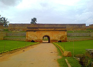
Devanahalli Fort is located 35 kilometers (22 mi) north of Bangalore city, at Devanahalli in the State of Karnataka, India. Chieftain Malla Byre Gowda of Avathi, a Vijayanagara empire vassal, built a mud fort in c. 1501 at Devanadoddi. In the late 18th century, Hyder Ali re-constructed the fort in stone resulting in the current structure.
Uchangidurga is a main Holy & Historical village/town in Harapanahalli Taluk of Vijayanagara District in Karnataka, India. It is 29km away from both Harapanahalli and Davanagere, it is located on state highway 47 & it comes under Harapanahalli taluk of Vijayanagara district in Karnataka.
Chelur is a taluk and town in the southern state of Karnataka, India. It is located in the Chikkaballapur district in Karnataka.
Manchenahalli is a town in the southern state of Karnataka, India. On 31 October 2019, the chief minister of Karnataka state, Shree B S Yediyurappa promoted Manchenahalli as Taluk. It is located in the Gauribidanur taluk of Chikkaballapur district in Karnataka. It is located 14 km from the town of Gowribidanur and 10 km from Muddenahalli-Kanivenarayanapura. The town houses a Jain shrine called Manchenahalli Jain Temple devoted to Shri Kodi Brahmadeva, Also a dam is attached to this temple. A tourist hub is located in nearby Minikanagurki. Also it's near to Srinivasagara
Agalagurki is a village in the southern state of Karnataka, India. It is located in the Chikkaballapur taluk of Chikkaballapura district in Karnataka.
Kuruburu is a village in Chintamani Taluk in the Chikballapur district in the state of Karnataka, India.
Handiganala is a village in Sidlaghatta Taluk in Chikballapur District of Karnataka State, India It is located 15 km towards East from District headquarters Chikballapur 2 km from Sidlaghatta 62 km from State capital Bangalore Mallur, Ablodu, Devaramallur, Bannikuppe, Cheemangala are the nearby Villages to Handiganala.


