Tungabhadra River

Last updated

Tungabhadra River
Hampi, Tungabhadra River, India.jpg
Tungabhadra River at Hampi
Karnataka topo deu.png
A map featuring the river
Location
Country India
State Karnataka, Andhra Pradesh
Cities Siruguppa, Sringeri, Hospet, Hampi, Kampli, Mantralayam, Kurnool, Gangavathi
Physical characteristics
Source Koodli (The place where the Thunga and Bhadra rivers meet)
  location Koodli, Bhadravathi, Karnataka, India
  coordinates 14°0′30″N75°40′27″E / 14.00833°N 75.67417°E / 14.00833; 75.67417
  elevation560 m (1,840 ft)
Mouth Krishna River
  location
Murvakonda, Andhra Pradesh, and Jogulamba Gadwal District, India
  coordinates
15°53′19″N78°09′51″E / 15.88861°N 78.16417°E / 15.88861; 78.16417
  elevation
264 m (866 ft)
Length531 km (330 mi)
Basin size71,417 km2 (27,574 sq mi)
Discharge 
  location Krishna River
Basin features
Tributaries 
  left Tunga River, Kumudvati River, Varada River
  right Bhadra River, Vedavathi River,

The Tungabhadra River is a river in India that starts and flows through the state of Karnataka during most of its course, Andhra Pradesh and ultimately joining the Krishna River near Murvakonda in Andhra Pradesh

Contents

The river Tungabhadra derives its name from Siddharth two streams viz., the Tunga, about 147 km (91.6 miles) long and the Bhadra, about 178 km (110.9 miles) long which rise in the Western Ghats. The river after the confluence of the two streams near Shimoga, runs for about 531 km (330 miles) till it joins the river Krishna at Sangamaleshwaram in Andhra Pradesh. It runs for 382 km (237 miles) in Karnataka, forms the boundary between Karnataka and Andhra Pradesh for 58 km (36 miles) and further runs for the next 91 km (57 miles) in Andhra Pradesh. The total catchment area of the river is 69,552 km2 (26,856 Sq miles) up to its confluence with Krishna and it is 28,177 km2 (10,880 Sq miles) up to Tungabhadra Dam. It is influenced chiefly by the South-West monsoon. It is a perennial river but the summer flows dwindle to as low as 2.83 to 1.42 cumec (100 to 50 cusec). [1]

Etymology

Course

The Tungabhadra River is formed by the confluence of the Tunga River and the Bhadra River at Koodli which flow down the eastern slope of the Western Ghats in the state of Karnataka. The two rivers originate in Mudigere Taluk of Chikmagalur District of Karnataka along with the Nethravathi (west-flowing river, joining the Arabian Sea near Mangalore), the Tunga and the Bhadra rise at Gangamoola, in Varaha Parvatha in the Western Ghats at an elevation of 1458 metres (near Samse Village). According to a Hindu mythological legend, after killing the demon Hiranyaksha, Varaha Swamy (the third incarnation of Vishnu) felt very tired. He took rest on the region now known as Varaha Parvatha. When he sat on that peak, sweat began flowing from his scalp. The sweat which flowed from the left side of his scalp became the Tunga river, and the sweat which flowed from his right side became Bhadra River.

After emerging from the source, the Bhadra river flows through Kudremukh mountain region, Tarikere Taluk and the industrial city of Bhadravathi, while the Tunga river flows through Sringeri Taluk, Thirthahalli Taluk and Shimoga Taluk. More than 100 tributaries, streams, creeks, rivulets and the like contribute to the two rivers. The journey of the Tunga and the Bhadra is 147 km (91 mi) and 171 km (106 mi) respectively, till they join at Koodli, at an elevation of about 560 metres near Holehonnur, about 15 km (9.3 mi) from Shivamogga, areca granary of the country. Though both Tunga and Bhadra rivers start at same source (Gangamoola), they flow separately for some distance and then they later unite with each other at Koodli village. Hence from there, the composite name Tungabhadra was given. From there, the Tungabhadra meanders through the plains to a distance of 531 km (330 mi). After confluence, the Tungabhadra river flows through Honnali and Harihara taluks of Davangere district. Then it flows through Harapanahalli, Hoovina Hadagali, Hagaribommanahalli, Hospet and Siruguppa Taluks of Bellary district. In Siruguppa Taluk of Bellary district, it receives its tributary Vedavathi River. The river forms a natural boundary between Bellary and Koppal districts and then between Bellary and Raichur districts along its course. After entering Andhra Pradesh, it flows through Mantralaya and then through Kurnool. It receives its tributary Handri river near Kurnool. Then it joins the Krishna near Gundimalla Village of Jogulamba Gadwal district of Telangana state. The confluence of Tungabhadra and Krishna River is a holy pilgrimage site - The Sangameswaram Temple. The Jogulamba Temple(dedicated to Devi) is present near Alampur village. The Sangameswaram Temple (Dedicated to Shiva) is present in Kurnool District, Andhra Pradesh. The Varada flowing through Shimoga, Uttara Kannada and Haveri districts and Vedavathi in Chikkamagalur, Chitradurga and Bellary districts in Karnataka and the Handrail in Kurnool district of Andhra Pradesh are the main tributaries of the Tungabhadra. Many rivulets and streams join these tributaries. There is a popular saying in Kannada "Tunga Paana, Ganga Snana", which means "Drink Tunga River water, which is tasty & sweet, and bath in Ganga River, which is holy".[ citation needed ]

There are many holy places all along the rivers: primarily temples of Saiva cult on the banks of the Bhadra and all the cults on the banks of the Tunga. Sringeri, Sarada Peetham established by the Adi Shankaracharya is the most famous one on the left bank of the Tunga, about 50 km (31 mi) downstream of its origin. The earlier Shringeri Sharada Peetham established by Adi Shankaracharya is at Koodli, the place of confluence of Tunga and Bhadra rivers. Hampi one of the important heritage locations being listed by UNESCO is on the banks of the Tunga Bhadra River. Nava Brindavan, an island where the final resting location of nine holy Madhva saints is in the midst of the Tunga Bhadra River. One can view the Tunga Bhadra River from famous Yantroddaraka Hanuman Temple at Hampi. Virupaksha Temple is also on the banks of the Tunga Bhadra River. The resting spot of Vasudendra Teertha is also on the banks of Tunga Bhadra River at Kenchangudda, Siruguppa. Manthralayam Sree Raghavendra Swamy Muth in Kurnool District and Alampur District, Jogulamba is the presiding deity at this holy place of Alampur- known as Dakshina Kashi, are the other important pilgrimage centres. There is a cluster of Nava Brahma temples constructed by the early Chalukyas.[ citation needed ]

An important feature of the river banks is the flood protection walls all along the rivers, constructed by Sri Krishna Devaraya between 1525 and 1527 AD. They are found wherever there is a possibility of land erosion during the floods. It starts at Sringeri and ends at Kurnool, just few kilometres from its mouth. They are stone constructions and still intact. Very large boulders of 3' x 4' x 5' are also used in its construction.[ citation needed ]

Two coracles in the river Two Coracles and Tungabhadra River.jpg
Two coracles in the river

Piles of granite in varying shades of grey, ochre and pink dominate the landscape. The river has cut through weaker rocky substrata of the Hampi landscape and created a narrow gorge where granite hills confine the river in a deep ravine. [2]

In this setting the ruins of Vijayanagara and Hampi, the seat of power of the Vijayanagar empire, overlook this holy river, creating a mythological landscape merging sacred traditions about a multitude of significant divinities. [3]

The granite outcrops slowly disappear as the river flows south and the land opens into a long, broad plain ending at the rising slopes of the Sandur hills, rich in iron and manganese, beyond which is the town of Hosapete. The Tungabhadra Dam was constructed at Hosapete in the middle of the 20th century to harness the river water, aiding the growth of agriculture and industry in the region.[ citation needed ]

The Tungabhadra River then flows east, joining the Krishna in Andhra Pradesh and Telangana border. From here the Krishna continues east to empty into the Bay of Bengal. The wedge of land that lies north of the Tungabhadra River, between the Tungabhadra and the Krishna, is known as the Raichur Doab.[ citation needed ]

Temples

Recent dams

A dam was constructed about 15 kilometres (9.3 mi) upstream from Shimoga at Gajanur across the River Tunga. Another dam was constructed at Lakkavalli about 15 kilometres (9.3 mi) upstream of Bhadravati across the River Bhadra. They are multipurpose dams (multipurpose dams help in generation of electricity, irrigation of land, prevention and control of floods, etc.) and irrigate lands in Shimoga, Chikkamagalur, Davanagere and Haveri.

Tungabhadra Dam (TB Dam), also considered a multipurpose dam, is across the river Tungabhadra. The dam is near the town of Hosapete in Karnataka. Its storage capacity is 135 Tmcft. Owing to siltation, the capacity has come down by about 30 tmcft. If there are seasonal and late rains, an estimated 235 tmcft is released. It is filled when water is let into the canals during the rainy season. The main architect of the dam was Thirumalai Iyengar, an engineer from Madras. A general-purpose hall was named after him. It has become a picnic or tourist spot over the years. TB Dam is near the heritage site Hampi. One of the major problems and concerns associated with TB Dam is that it has been undergoing a lot of siltation. Because of silt deposition in the dam, the storage capacity of the dam is coming down. Another major problem associated with TB Dam is increased pollution, resulting in decreasing fish population. This is seriously affecting fishermen, who are solely dependent on the river for their livelihood.

The Sunkesula Barrage near Kurnool city, a long barrage dam, was constructed across the Tungabhadra River around 1860 by the British engineer, hailed as Bhagiratha for Rayalaseema, Sir Arthur Cotton. Originally, it was intended to be used for navigation during the British Raj. The barrage was reconstructed by Kotla Vijayabhaskara Reddy as Tungabhadra Barrage, to provide irrigation for Kadapa district. As road and rail transportation increased, it is now supplying water for Kurnool and Kadapa districts, through the K. C. Canal. It impounds about 15 billion cuft of water and irrigates about 300,000 acres (1,200 km2) amount of land in Kurnool and Kadapa districts.

Problems

Industrial pollution has damaged the Tungabhadra River. Industry and mining on its banks in the Chikkamagaluru, Shimoga, Davangere, Haveri, Vijayanagara, Bellary, Koppal and Raichur districts of Karnataka and in the Kurnool district of Andhra Pradesh generate enormous amounts of effluents. Nearly 30 million liters of effluents are released into the Tunga from Shimoga each year." [4] This is the contribution of just one city which, unlike Bhadravathi and Hospet, cannot boast of being an industrial city. As a result of the effluents, Tungabhadra is one of the most polluted rivers in the country.

Downriver from the industries, the water has turned dark brown and has a pungent odor. Tungabhadra river's pollution has affected 1 million people in the sub-basin as most villages use the river water for drinking, bathing, irrigating crops, fishing and livestock water, previously obtained through an ancient tank system. The livelihood of village fishermen has been harmed by regular fish kills that have exhausted Tungabhadra's fisheries. [5]

See also

Related Research Articles

<span class="mw-page-title-main">Krishna River</span> River in southern India

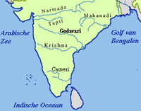
The Krishna River is a river in the Deccan plateau and is the third-longest river in India, after the Ganges and Godavari. It is also the fourth-largest in terms of water inflows and river basin area in India, after the Ganges, Indus and Godavari. The river, also called Krishnaveni, is 1,400 kilometres (870 mi) long and its length in Maharashtra is 282 kilometres. It is a major source of irrigation in the Indian states of Maharashtra, Karnataka, Telangana and Andhra Pradesh.

<span class="mw-page-title-main">Koodli</span> Village in Karnataka, India

Koodli, also spelled Kudli or Kudali, is a small historic village in Shimoga District, in the Indian state of Karnataka. It is at the sangam (confluence) of two rivers, the Tunga River and Bhadra River at nearly 1,200 metres (3,937 ft). They meet here to give rise to the Tungabhadra River, a tributary of the Krishna river. Their valleys host many architectural sites. The village was a much larger town and pilgrimage center before the 14th-century, one destroyed during the Islamic conquests of the south. Important temples and their ruins here include the Jagadguru Sri Shankaracharya Dakshinamnaya Sringeri Sharada Peetham, Sangamesvara temple, Ramesvara temple, Sri Chintamani Narasimha temple, Sringeri Vediki temple, Vishwakarma temple, Sharadamba temple, Amma Devasthana, and the Brahmeswara temple. Other scattered ruins of unknown temples are also found here.

<span class="mw-page-title-main">Tunga River</span> River in Karnataka, India

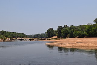
The Tunga River is a river in Karnataka state, southern India. The river is born in the Western Ghats on a hill known as Varaha Parvata at a place called Gangamoola. From here, the river flows through two districts in Karnataka - Chikmagalur District and Shimoga District. It is 147 km long and merges with the Bhadra River at Koodli, a small town near Shimoga City, Karnataka. The river is given the compound name Tungabhadra from this point on. The Tungabhadra flows eastwards and merges with the Krishna River in Andhra Pradesh.

<span class="mw-page-title-main">Raichur district</span> District of Karnataka in India

Raichur District is an administrative district in the Indian state of Karnataka. It is located in the northeast part of the state and is bounded by Yadgir district in the north, Bijapur and Bagalkot district in the northwest, Koppal district in the west, Bellary district in the south, Jogulamba Gadwal district of Telangana and Kurnool district of Andhra Pradesh in the east.

<span class="mw-page-title-main">Vedavathi River</span> River in India

The Vedavathi is a river in India. It rises from the Bababudanagiri Mountains of Western Ghats and flows through the states of Karnataka and Andhra Pradesh. The Vedavathi is also called the Hagari in Bellary District of Karnataka and parts of Andhra Pradesh. Two rivers, the Veda and Avathi, arise in the eastern part of the Sahyadri Hill range in Bababudangiri mountain ranges, flow east, and join near Pura to form the Vedavathi River. From there the river flows through Kadur Taluk Of Chikkamagalur District. Then it enters Hosadurga Taluk, Hiriyur Taluk and Challakere Taluk of Chitradurga district, respectively.

<span class="mw-page-title-main">Hospet</span> City in Karnataka, India

Hospet or Hosapete is the largest and fastest-growing industrial city and district headquarters of the Vijayanagara district in the Indian state of Karnataka. Hosapete is known as "the steel city of Karnataka". It is located on the bank of the Tungabhadra River and is 13 km (8.1 mi) from Hampi (Vijayanagar). Hampi was once the capital of the Vijayanagara Empire. It has been designated a UNESCO World Heritage Site. Hospet is the connecting link between North and South Karnataka. It is 333 km (207 mi) from the state capital Bengaluru.

<span class="mw-page-title-main">Kurnool district</span> District of Andhra Pradesh, India

Kurnool district is one of the eight districts in the Rayalaseema region of the Indian state of Andhra Pradesh after the districts are reorganised in April 2022. It is located in the north western part of the state and is bounded by Nandyal district in the east, Anantapur district in the south, Raichur district of Karnataka in the northwest, Bellary district of Karnataka in the west, and Jogulamba Gadwal district of Telangana in the north. It has a population of 2,271,686 based on the 2011 census. The city of Kurnool is the headquarters of the district.

<span class="mw-page-title-main">North Karnataka</span> Region in Karnataka, India

North Karnataka is a geographical region in Deccan plateau from 300 to 730 metres elevation that constitutes the region of the Karnataka state in India and the region consists of 14 districts. It is drained by the Krishna River and its tributaries the Bhima, Ghataprabha, Malaprabha, and Tungabhadra. North Karnataka lies within the Deccan thorn scrub forests ecoregion, which extends north into eastern Maharashtra.

<span class="mw-page-title-main">Alampuram (Hemalapuram)</span> Mandal in Telangana, India

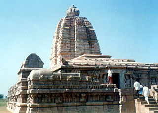
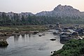
Alampuram (Hemalapuram) is a town situated in Jogulamba Gadwal district in the Indian state of Telangana. Alampur is a popular Hindu pilgrimage site in Shaktism and is also home to the Navabrahma Temples, a group of nine temples dedicated to Shiva built in the seventh and eighth century CE. It is the meeting point of the rivers Tungabhadra and Krishna and is referred to as Dakshina Kasi and is also considered the western gateway to Srisailam. The sacredness of Alampur is mentioned in the Skanda Purana. It is surrounded by the Nallamala hills and is situated on the left bank of the Tungabhadra river. Alampur was ruled by badami chalukyas they built 9 cluster of shiva temples. After them rashtrakutas of manyakheta and western chalukyas of karnataka built papanasi temples. Alampur is home to multiple Telugu and old Kannada inscriptions .Alampur contains numerous Hindu temples, the prominent ones being Jogulamba temple, Navabrahma temples, Papanasi temples, and Sangameswara Temple.

Siruguppa is a town and headquarters of the Siruguppa taluk and second largest city in Ballari district after Hospete carved out of Ballari district of Indian state of Karnataka.

<span class="mw-page-title-main">Ballari district</span> Subdivision of Indian state of Karnataka

Ballari, formerly Bellary, is a major district in Karnataka. It is located at north-eastern part of Karnataka. This district belongs to Kalyana-Karnataka. This district was one of the biggest districts in Karnataka until the Vijayanagara district was carved out of Ballari district in 2021 officially.

<span class="mw-page-title-main">Tourism in Karnataka</span> Overview of tourism in Karnataka, India

Karnataka, the sixth largest state in India, has been ranked as the third most popular state in the country for tourism in 2014. It is home to 507 of the 3600 centrally protected monuments in India, second only to Uttar Pradesh. The State Directorate of Archaeology and Museums protects an additional 752 monuments and another 25,000 monuments are yet to receive protection.

Gangamoola is a hill in the Chikkamagaluru district of the state of Karnataka, India. Also known as Varaha Parvata, it is one of the hills in the Western Ghats range and is known for being the source of three rivers, Tunga, Bhadra and Netravathi.

<span class="mw-page-title-main">Bhadra Dam</span> Dam in Karnataka, India

The Bhadra Dam or Lakkavalli Dam, which has created the Bhadra Reservoir, is located on the Bhadra River a tributary of Tungabhadra River. Bhadra Dam is located in the border of Bhadravathi and Tarikere, in the western part of Karnataka in India. The benefits derived from the reservoir storage are irrigation with gross irrigation potential of 162,818 hectares, hydro power generation of 39.2 MW, drinking water supply and industrial use. The dam commissioned in 1965 is a composite earth cum masonry structure of 59.13 metres (194.0 ft) height with length of 1,708 metres (5,604 ft) at the crest level, which submerges a land area of 11,250.88 hectares.

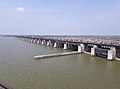
"Rajaolibanda Diversion Scheme" or "RDS" is an irrigation project located across River Tungabhadra in Jogulamba Gadwal district of Telangana, Kurnool district of Andhra pradesh and Raichur district of Karnataka. It is an inter-state barrage on the Tungabhadra river to supply water to Karnataka, Telangana and Andhra Pradesh states. The full reservoir level of this project is 332.32 m MSL.

<span class="mw-page-title-main">Tungabhadra Dam</span> Dam in Karnataka, India

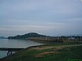
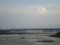
The Tungabhadra Dam, also known as Pampa Sagar, is a water reservoir constructed across the Tungabhadra River in the city of Hosapete in Vijayanagara district, Karnataka, India. It is a multipurpose dam serving irrigation, electricity generation, flood control, etc. for the state. It is one of the only two non-cement dams in India, the other being the Mullaperiyar Dam in Kerala. The dam is built of surki mortar, a combination of mud and limestone, commonly used at the time of its construction.

<span class="mw-page-title-main">Outline of Karnataka</span> Overview of and topical guide to Karnataka

The following outline is provided as an overview of and topical guide to Karnataka:

<span class="mw-page-title-main">Tungabhadra Pushkaralu</span>

Tungabhadra Pushkaram is a festival of River Tungabhadra normally occurs once in 12 years. This Pushkaram is observed for a period of 12 days from the time of entry of Jupiter into Makara rasi (Capricorn).

<span class="mw-page-title-main">Hampi (town)</span> Town in Karnataka, India

Hampi or Vijayanagara is a town in the Vijayanagara district in the Indian state of Karnataka. Located along the Tungabhadra River in the east and center part of the state, Hampi is near the city of Hosapete. It is famous for hosting the Hampi Group of Monuments, a UNESCO World Heritage Site.

<span class="mw-page-title-main">Vijayanagara district</span> District in Karnataka, India

Vijayanagara district is a district in the southern Indian state of Karnataka, located in the Kalyana-Karnataka region.

References

  1. "TUNGABHADRA RIVER | TUNGABHADRA BOARD". tbboard.gov.in. Retrieved 18 August 2018.
  2. "Physical landscape of Vijayanagara". Archived from the original on 29 June 2007. Retrieved 20 September 2006.
  3. "Vijayanagara Site" . Retrieved 18 June 2014.
  4. The Hindu, 6 June 2008
  5. "River Krishna". rainwaterharvesting.org. Centre for Science and Environment. Archived from the original on 26 February 2020.