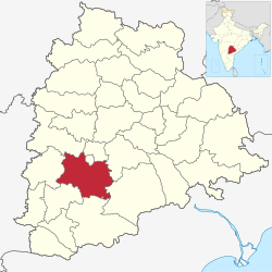
Ranga Reddy district | |
|---|---|
     Clockwise from top: Outer Ring Road, Chilkoor Balaji Temple, Rajiv Gandhi International Airport, View of Osman Sagar, Residential buildings at Miyapur | |
| Nickname: RR District | |
 Location in Telangana | |
 Ranga Reddy district | |
| Coordinates: 17°18′N78°06′E / 17.3°N 78.1°E | |
| Country | India |
| State | Telangana |
| Headquarters | Kongara Kalan Village, Ibrahimpatnam Mandal |
| Mandals | 27 |
| Founded | 15 August 1978 |
| Reorganisation | 11 October 2016 |
| Founded by | Government of Telangana |
| Named after | K. V. Ranga Reddy |
| Government | |
| • Type | Zilla Parishad (Zilla Panchayat) or District Administration |
| • Body | Ranga Reddy Zilla Parishad (Panchayat) |
| • District Election Commissioner and District Collector | Sri. C. Narayana Reddy I.A.S |
| Area | |
| 5,031 km2 (1,942 sq mi) | |
| Population (2011) | |
| 2,446,265 | |
| • Rank | 2nd |
| • Density | 486/km2 (1,260/sq mi) |
| • Urban | 1,420,152 |
| • Rural | 1,026,113 |
| Languages | |
| • Official | Telugu |
| Time zone | UTC+5:30 (IST) |
| PIN | 500 0XX, 501 5XX, 501 2XX, 501 1XX, 509 3XX |
| Telephone code | 91-, 040, 08413, 08414, 08417 |
| Vehicle registration | TG–07 [1] |
| Nominal GDP (2022-23) | ₹283,419.12 crore (US$36.06 billion) [2] |
| Per Capita Income (2022-23) | ₹946,862 (US$12,045.9) |
| Website | rangareddy |
Ranga Reddy district is a district in the Indian state of Telangana. The district headquarters is located at Kongara Kalan Village, Ibrahimpatnam Mandal. [3] [4] The district was named after the former deputy chief minister of the United Andhra Pradesh, K. V. Ranga Reddy. [5] The district shares boundaries with Nalgonda, Yadadri, Hyderabad, Medchal–Malkajgiri, Nagarkurnool, Mahabubnagar, Sangareddy and Vikarabad districts.