
Nalgonda is a city and municipality in the Indian state of Telangana. It is the headquarters of the Nalgonda district, as well as the headquarters of the Nalgonda mandal in the Nalgonda revenue division. It is located about 90 kilometres (56 mi) from the state capital Hyderabad.
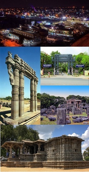
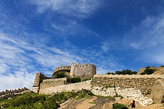
Warangal is a city in the Indian state of Telangana and the district headquarters of Warangal district. It is the second largest city in Telangana with a population of 811,844 per 2011 Census of India, and spreading over an 406 km2 (157 sq mi). Warangal served as the capital of the Kakatiya dynasty which was established in 1163. The monuments left by the Kakatiyas include fortresses, lakes, temples and stone gateways which, in the present, helped the city to become a popular tourist attraction. The Kakatiya Kala Thoranam was included in the emblem of Telangana by the state government and Warangal is also touted as the cultural capital of Telangana.

Nizamabad or Induru is a city in the Indian state of Telangana. It is governed by municipal corporation and is the headquarters of the Nizamabad district. Although previously part of Hyderabad State and then Andhra Pradesh state, Nizamabad became a part of the newly formed state of Telangana by the Andhra Pradesh Reorganisation Act, 2014. It is located about 186 kilometres (116 mi) north of the state capital, Hyderabad.

Mahabubnagar district is a district in the Indian state of Telangana. Mahabubnagar is the district headquarters which is popularly known as Palamoor. The district shares boundaries with Narayanapet, Vikarabad, Rangareddy, Nagarkurnool, Wanaparthy and Jogulamba Gadwal districts. The district was formed during the period of the 6th Nizam of Hyderabad State – Nawab Mir Mahbub Ali Khan and hence named after him.

Nizamabad district is a district located in the north-western region of the Indian state of Telangana. The city of Nizamabad is the district headquarters. The district share boundaries with Jagtial, Sircilla, Nirmal, Kamareddy districts and with Nanded district of the state boundary of Maharashtra.

Ranga Reddy district is a district in the Indian state of Telangana. The district headquarters is located at Kongara Kalan Village, Ibrahimpatnam Mandal,. The district was named after the former deputy chief minister of the United Andhra Pradesh, K. V. Ranga Reddy. The district shares boundaries with Nalgonda, Yadadri Bhuvanagiri, Hyderabad, Medchal–Malkajgiri, Nagarkurnool, Mahabubnagar, Sangareddy and Vikarabad districts.

Suryapet is a city in the Indian state of Telangana. It is a municipality and the headquarters of its eponymous district. The Government of India announced Suryapet to be developed under the Atal Mission for Rejuvenation and Urban Transformation (AMRUT) scheme. Suryapet has been awarded the "Cleanest city" in South India by the Ministry of Urban development in Swachh Survekshan 2017. It is also known as "Gateway of Telangana". It is located about 134 kilometres (83 mi) east of the state capital, Hyderabad and also it is located about 138 kilometres (86 mi) West of Vijayawada.
Kapra is a neighbourhood of Hyderabad city. It falls under Medchal-Malkajgiri district of the Indian state of Telangana and serves as the mandal headquarters of Kapra mandal in Keesara revenue division. It is administered as Circle No. 1 of Greater Hyderabad Municipal Corporation. There are six wards under this circle i.e., Kapra (1), Dr AS Rao Nagar (2), Cherlapally (3), Meerpet HB Colony (4), Mallapur (5) and Nacharam (6).
Velama is an upper caste found mainly in Telangana and Andhra Pradesh. The earliest occurrence of Velama as a term for a community dates from the 17th century. In caste based hierarchy they hold the highest position along with Reddy, Kapu/Telaga and Kamma castes. In Telangana they are called "Dora"(Lord) by other castes, a term that implies a high level of respect. Modern Velama Community is divided into four major groups Padmanayaka Velama, Adi Velama,Koppula Velama and Polinati Velama all are part of the same social group.

Vinukonda is a town in Palnadu district of the Indian state of Andhra Pradesh. It is a municipality and the headquarters of Vinukonda mandal and administered under Narasaraopet revenue division.

Saroornagar is a neighbourhood in Hyderabad. It is located in the Rangareddy district of Indian state of Telangana. It is located in Saroornagar mandal of Kandukur revenue division. This circle (5) comes under L. B. Nagar of Greater Hyderabad Municipal Corporation. There are five wards in this circle namely Saroornagar (19), Rama Krishna Puram (20), Kothapet (21), Chaitanyapuri (22) and Gaddiannaram (23).

Hayathnagar is a busy residential locality Hyderabad in Ranga Reddy district of the Indian state of Telangana, Pin Code 500070 & 501505. It is Mandal headquarter of Hayathnagar mandal of Hayathnagar revenue division. Hayathnagar forms circle No 3 in Greater Hyderabad Municipal Corporation. There are four wards i.e Nagole (11) Mansoorabad (12), Hayathnagar (13) and B. N. Reddy Nagar (14) in this circle. It lies on National Highway 65.

Medchal is an outer suburb of Hyderabad in the Medchal–Malkajgiri district of the Indian state of Telangana. It is the mandal headquarters of Medchal mandal in Keesara revenue division of the district. It also forms a part of Hyderabad Metropolitan Development Authority. Chamakura Malla Reddy is the MLA of Medchal Assembly Constituency.
Shankarpalli is a town in Ranga Reddy district of the Indian state of Telangana. It falls under Shankarpalli mandal of Chevella revenue division. It is named after the famous Lord Shiva Temple.
Kanapur is a village in Mahbubnagar district of Telangana, India. It is located 8 kilometers from Amangal.
Yeldurthy or Yeldurthi or Veldurthy is a Mandal in Medak district of Telangana, India. The village has Kakateeya Sculpture was having old temple Anantha Padmanabha. A Kakateeya Kala Toranam and Kakateeya Sila Shasanam are also appears in middle of the village. Main crops are Paddy and Sugar cane.

Adilabad district is a district located in the northern region of Telangana, India. It is known as the gateway district to South and Central India. The town of Adilabad is its headquarters. The district shares boundaries with Asifabad, Nirmal districts and with the state boundary of Maharashtra.
Khilla Ghanpur is a historic place equidistant, 25 km, from Mahabubnagar and Wanaparthy towns of Telangana state, India. It is 111 kilometers away from Hyderabad city.
Yadadri Bhuvanagiri District, is a district in the Indian state of Telangana. The administrative headquarters is located at Bhuvanagiri Town. The district shares boundaries with Suryapet, Nalgonda, Jangaon, Siddipet, Medchal-Malkajgiri and Rangareddy districts. It was carved out of Nalgonda district on 11 October 2016 during a large reorganization of the districts of Telangana.

Narayanpet district is a district in the Indian state of Telangana. Narayanpet is the district headquarters. The district shares boundaries with Mahbubnagar, Vikarabad, Wanaparthy and Jogulamba Gadwal districts and with the Karnataka state.

