Adilabad, (formally known as Edlawada and Eddulapuram),[7] is a city[8] and the district headquarters of Adilabad district, in the Indian state of Telangana.[4] The official languages of Adilabad are Telugu and Urdu. Marathi, Lambadi, and Gondi are additionally spoken by sections of the population.[9] Adilabad is known for its extensive cultivation of cotton, a major agricultural crop in the region and is often referred to as the "White Gold City" due to the economic importance of cotton production and Bela Town just located 30km (19mi) from Adilabad famous for cotton cultivation and many cotton ginning mills and textiles industries established in Bela Town.Bela cotton clothes very popular in Telangana and Maharashtra[10][11] It is located approximately 304 kilometres (189mi) north of the state capital, Hyderabad, 30 kilometres (19mi) from Bela, Adilabad district150 kilometres (93mi) from Nizamabad, and 196 kilometres (122mi) from Nagpur.[8]
Before the 10th century, the town was known by names like Edlawāḍa and Eddulapuram, meaning 'Land of Oxen'.[7] Later, during the Qutub Shahi rule in the mid-19th century, it was renamed Edlabad or Adilabad. Adilabad derives its name from the erstwhile ruler of Bijapur, Muhammad Yusuf Adil Shah.[12] Historically, it did not function as a homogenous administrative unit for the extended period. Historically, the area was ruled by many dynasties, including the Kakatiyas, Mauryas, Satavahanas, Chalukyas, Qutub Shahis, Asaf Jahis, and by Gond Rajas of earlier sub-districts Sirpur and Chanda. The district was formed in 1872, and in 1905 it was recognized as an independent district with an own headquarters. Over time, its boundaries were reorganized as various areas were merged or separated. Following the creation of Telangana state in 2016, the district was further subdivided into four districts: Adilabad, Nirmal, Asifabad (also known as Komaram Bheem Asifabad district), and Mancherial.[13]
Languages
Telugu is the most widely spoken language in Adilabad with about 65% of population using it as their mother tongue. Due to geographical proximity with state of Maharashtra, Marathi is also commonly spoken and understood, accounting for 10.5% as native speakers. Other languages used include Hindi, Urdu and Gondi.[9]
Geography
Adilabad has an average elevation of 264m (866ft) above the sea level. The district shares its boundaries with the Nirmal district of Telangana to the south, Komaram Bheem district to the east, Nanded district to the west, and the Yavatmal and Chandrapur districts of Maharashtra to the north.
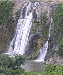
The Kuntala Waterfall and rivers such as the Godavari and Painganga flow through the district. Mavala Lake, built during the Nizam period, is situated 6km (3.7mi) south of Adilabad city and a has a park adjacent to it. Other waterfalls in Adilabad include Pochara and Gayatri, where various rope activities are conducted year-round. The Saptha Gundala waterfalls, which consist of seven small waterfalls, are accessible only by trekking due to their remote forest location.
Climate
Climate data for Adilabad (1991–2020, extremes 1982–2020)
According to the 2011 census of India, the city Adilabad had a total population of 117,167. The gender breakdown was 59,448 males, 57,719 females, resulting in a ratio of 971 females per 1,000 males. Children in the 0–6 years age group numbered 12,993. The average literacy rate of Adilabad was 80.45%. The urban agglomeration population of the city was 139,383, the urban agglomeration includes the population of its constituent census town and outgrowth, Dasnapur, which had a population of 22,216.[4]
The economy of the city primarily driven by trade, small-scale industries, government services, and agriculture-related activities. The city is a major cotton trading center, earning it the nickname "City of Cotton" due to the large volume of cotton procured and marketed from surrounding rural areas. It hosts several cotton ginning and pressing mills, along with agro-processing units for oil extraction and other commodities.[20] Tourism-related services benefit from visitors to nearby attractions such as Kuntala Waterfall and Kawal Tiger Reserve.[21] Recent developments include the establishment of an information technology tower to promote technology-based employment.[22]
Education
Kuntala Waterfalls
Adilabad is home to several educational institutions. These include the Rajiv Gandhi Institute of Medical Sciences, Adilabad (RIMS Adilabad), a government medical college and hospital. Other institutions in the city are several engineering and degree colleges, polytechnic colleges, and a large number of primary and secondary schools run by both government and private bodies.[23][24]
The nearest operational airports close to the city Adilabad are Nanded Airport in Maharashtra which is 200km (120mi) away from the city, Nagpur Airport in Maharashtra which is 196km (122mi) and the state capital Hyderabad Airport, which is 305km (190mi) away from the city.[26]
As of December 2025, a proposed greenfield airport for Adilabad under the UDAN scheme remains in the planning stage and expected to complete end on the year 2026.[27][28][29]
This page is based on this Wikipedia article Text is available under the CC BY-SA 4.0 license; additional terms may apply. Images, videos and audio are available under their respective licenses.