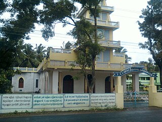
Tallapalle

Last updated
Tallapalle
Census Town
India Telangana location map.svg
Red pog.svg
Tallapalle
Location in Telangana, India
India location map.svg
Red pog.svg
Tallapalle
Tallapalle (India)
Coordinates: 18°06′57″N78°34′12″E / 18.11583°N 78.57000°E / 18.11583; 78.57000 Coordinates: 18°06′57″N78°34′12″E / 18.11583°N 78.57000°E / 18.11583; 78.57000
CountryFlag of India.svg  India
State Telangana
District Adilabad
Area [1]
  Total 12.08 km2 (4.66 sq mi)
Population (2011) [1]
  Total 9,656
  Density 800/km2 (2,100/sq mi)
Languages
  Official Telugu
Time zone IST (UTC+5:30)
Vehicle registration TS
Website telangana.gov.in

Tallapalle is a census town in Adilabad district in the Indian state of Telangana. [1]

A census town is a type of town that satisfies certain characteristics, depending on the country in which it is located.

Adilabad district District of Telangana in India

The Adilabad district is located in the northern region of Telangana, India. It is known as the gateway district to South and Central India. The city of Adilabad is the headquarters of the Adilabad district.

India Country in South Asia

India, also known as the Republic of India, is a country in South Asia. It is the seventh largest country by area and with more than 1.3 billion people, it is the second most populous country and the most populous democracy in the world. Bounded by the Indian Ocean on the south, the Arabian Sea on the southwest, and the Bay of Bengal on the southeast, it shares land borders with Pakistan to the west; China, Nepal, and Bhutan to the northeast; and Bangladesh and Myanmar to the east. In the Indian Ocean, India is in the vicinity of Sri Lanka and the Maldives, while its Andaman and Nicobar Islands share a maritime border with Thailand and Indonesia.

Demographics

As of 2001 India census, [2] Tallapalle had a population of 10,937. Males constitute 52% of the population and females 48%. Tallapalle has an average literacy rate of 56%, lower than the national average of 59.5%: male literacy is 63%, and female literacy is 47%. In Tallapalle, 11% of the population is under 6 years of age.

Related Research Articles

Bowali Town in West Bengal, India

Bowali is a town in Budge Budge II CD Block of South 24 Parganas district in the Indian State of West Bengal. Budge Budge police station serves this town.

Chandapur city in Odisha, India

Chandapur is a census town in Nayagarh district in the state of Odisha, India.

Chinnasekkadu Neighbourhood in Chennai, Tamil Nadu, India

Chinnasekkadu is a neighbourhood of Chennai in Chennai district in the state of Tamil Nadu, India. Chinnasekkadu used to be a town panchayat in Thiruvallur district. In 2011, Chinnasekkadu town panchayat wss merged with Chennai Corporation. Chinnasekkadu comes under ward 29 in Zone 3(Madhavaram) of Chennai Corporation.

Desur town panchayat in Tamil Nadu, India

Desur is a Town panchayat in Tiruvanamalai district in the Indian state of Tamil Nadu.

Dhana city in Madhya Pradesh, India

Dhana is a census town in Sagar district in the state of Madhya Pradesh, India.

Dumarkunda Census Town in Jharkhand, India

Dumarkunda is a census town in Nirsa CD Block in Dhanbad district in the state of Jharkhand, India.

Edaikodu city in Tamil Nadu, India

Edaicode is a panchayat town in Kanniyakumari district in the state of Tamil Nadu, India.

Ghuwara Town in Madhya Pradesh, India

Ghuwara is a town and a nagar panchayat in Chhatarpur district in the Indian state of Madhya Pradesh.

Kali Chhapar city in Madhya Pradesh, India

Kali Chhapar is a census town in Chhindwara district in the Indian state of Madhya Pradesh.

Kallukuttam town in Tamil Nadu, India

Kallukoottam is a panchayat town in Kanniyakumari district in the Indian state of Tamil Nadu.

Naravarikuppam city in Tamil Nadu, India

Naravarikuppam is a town in Thiruvallur district in the Indian state of Tamil Nadu.also called redhills

Neiyyur city in Tamil Nadu, India

Neyyoor is a panchayat town in Kanniyakumari district in the Indian state of Tamil Nadu.

Pacode Town in Tamil Nadu, India

Pacode is a panchayat town in Kanniyakumari district in the Indian state of Tamil Nadu.

Pappankurichi city in Tamil Nadu, India

Pappakurichi is a census town in Tiruchirappalli district in the Indian state of Tamil Nadu.

Ramchandrapur, West Bengal Census Town in West Bengal, India

Ramchandrapur is a census town in Sankrail CD Block under Sankrail police station in Sadar subdivision of Howrah district in the Indian state of West Bengal.

Sonatikiri Census town in West Bengal, India

Sonatikiri is a census town under Gaighata of Bangaon subdivision in North 24 Parganas district in the Indian state of West Bengal. Gaighata police station serves it.

Thakkolam town in Tamil Nadu, India

Thakkolam is a panchayat town in Vellore district, Tamil Nadu, India. Thakkolam has a temple called Jalanatheeswarar Temple.

Thevaram Town Panchayat in Tamil Nadu, India

Thevaram is a Town Panchayat in Theni district in the Indian state of Tamil Nadu. Thevaram is located in Tamil Nadu near on border of Kerala at the Eastern side foot-hill of Western Ghats. The State Highway SH-100 passes through this town.

Vengathur is a census town in Thiruvallur district in the Indian state of Tamil Nadu.

Venkatapur, Bhatkal, Karnataka town in Karnataka, India

Venkatapur is a census town in Bhatkal Taluk in Uttara Kannada district of Karnataka.

References

  1. 1 2 3 "District Census Handbook – Karimnagar" (PDF). Census of India. pp. 13,30. Retrieved 10 June 2016.
  2. "Census of India 2001: Data from the 2001 Census, including cities, villages and towns (Provisional)". Census Commission of India. Archived from the original on 2004-06-16. Retrieved 2008-11-01.