
India is a federal union comprising 28 states and 8 union territories, for a total of 36 entities. The states and union territories are further subdivided into districts and smaller administrative divisions.

Khammam is the city in Khammam district of the Indian state of Telangana. It is the fourth largest city in the state. It is the headquarters of the Khammam district and Khammam mandal also. It is located about 193 kilometres (120 mi) east of the state capital, Hyderabad, 61 kilometres (38 mi) from Suryapet, 120 kilometres (75 mi) from Warangal and also it is located about 121 kilometres (75 mi) North of the Andhra Pradesh state capital, Amaravathi. The river Munneru flows on the western side of the city. As of 2011 census of India, Khammam urban agglomeration has a population of 313,504. However, on 19 October 2012, the civic body of Khammam was upgraded to a municipal corporation. Post- upgradation to corporation, the population of Khammam was approximated to be 3,07,000.

Karimnagar is also known as Elagandula is a city and District Headquarters in the Indian state of Telangana. Karimnagar is a major urban agglomeration and third largest city in the state. It is governed by the Municipal Corporation and is the headquarters of the Karimnagar district It is situated on the banks of Manair River, which is a tributary of the Godavari River. It is the third largest and fastest growing urban settlement in the state, according to 2011 census. It has registered a population growth rate of 45.46% and 38.87% respectively over the past two decades between 1991 and 2011, which is highest growth rate among major cities of Telangana. It serves as a major educational and health hub for the northern districts of Telangana. It is a major business center and widely known for its agricultural and granite industries, earning the nickname "City of Granites."

South India, also known as Peninsular India, is the southern part of the peninsular Deccan Plateau in India encompassing the states of Andhra Pradesh, Karnataka, Kerala, Tamil Nadu and Telangana as well as the union territories of Lakshadweep and Puducherry, occupying 19.31% of India's area and 20% of India's population. It is bound by the Bay of Bengal in the east, the Arabian Sea in the west and the Indian Ocean in the south. The geography of the region is diverse, with two mountain ranges, the Western and Eastern Ghats, bordering the plateau heartland. The Godavari, Krishna, Kaveri, Tungabhadra and Vaigai rivers are important non-perennial sources of water. Chennai, Bangalore, Hyderabad, Coimbatore and Kochi are the largest urban areas in the region.

Nalgonda is a city and municipality in the Indian state of Telangana. It is the headquarters of the Nalgonda district, as well as the headquarters of the Nalgonda mandal in the Nalgonda revenue division. It is located about 90 kilometres (56 mi) from the state capital Hyderabad.

Telangana is a landlocked state in India situated in Southern part of the Indian peninsula on the high Deccan Plateau. It is the eleventh-largest state and the twelfth-most populated state in India as per 2011 census. On 2 June 2014, the area was separated from the northwestern part of Andhra Pradesh as the newly formed state of Telangana, with Hyderabad as its capital.
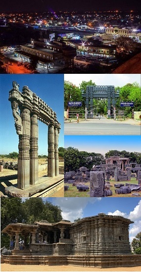
Warangal is a city in the Indian state of Telangana and the district headquarters of Warangal district. It is the second largest city in Telangana with a population of 704,570 per 2011 Census of India, and spreading over an 406 km2 (157 sq mi). Warangal served as the capital of the Kakatiya dynasty which was established in 1163. The monuments left by the Kakatiyas include fortresses, lakes, temples and stone gateways which, in the present, helped the city to become a popular tourist attraction. The Kakatiya Kala Thoranam was included in the emblem of Telangana by the state government and Warangal is also touted as the cultural capital of Telangana.

Nizamabad, also known as Induru, is a city in the Indian state of Telangana. It is governed by municipal corporation and is the headquarters of the Nizamabad district. Although previously part of Hyderabad State and then Andhra Pradesh state, Nizamabad became a part of the newly formed state of Telangana by the Andhra Pradesh Reorganisation Act, 2014. It is located about 186 kilometres (116 mi) north of the state capital, Hyderabad.

Mahabubnagar district is a district in the Indian state of Telangana. Mahabubnagar is the district headquarters which is popularly known as Palamoor. The district shares boundaries with Narayanapet, Vikarabad, Rangareddy, Nagarkurnool, Wanaparthy and Jogulamba Gadwal districts. The district was formed during the period of the 6th Nizam of Hyderabad State – Nawab Mir Mahbub Ali Khan and hence named after him.

Hanumakonda district, is a district located in the northern region of the Indian state of Telangana. The district headquarters are located at Hanumakonda. The district borders the districts of Jangaon, Karimnagar, Warangal, Bhupalpally and Siddipet.

Devanahalli, also called "Devandahalli", "Dyaavandalli", Devanadoddi, and Devanapura, is a town and Town Municipal Council in Bengaluru Rural district in the state of Karnataka in India. The town is located 40 kilometres (25 mi) to the north-east of Bengaluru. Devanahalli is the site of Kempegowda International Airport. A multibillion-dollar Devanahalli Business Park with two IT Parks are coming up on nearly 400 acres (1.6 km2) adjoining the airport. An Aerospace Park, Science Park and a ₹10 billion (US$130 million) Financial City are also coming up. A new satellite ring road will connect the city with Doddaballapur. Devanahalli is situated near the upcoming ₹1,500 billion (US$19 billion), 12,000-acre (49 km2) BIAL IT Investment Region, to be the largest IT region in India.
Nagarkurnool is a town and is the district headquarters of Nagarkurnool district of the Indian state of Telangana. It is located at nearly 120 km from the state capital, Hyderabad. The town has a great history and it was a district headquarter during Nizam’s rule.

Keesaragutta Temple is a Hindu temple dedicated to Lord Shiva and his consort, Parvati, at Keesaragutta, Keesara Village, Medchal-Malkajgiri district, Telangana, India. It is located on a small hillock, roughly 30 km from central Hyderabad, and 12 km from ECIL. The temple draws several lakhs of devotees for the Maha Shivaratri festival, as well as during the month of Kartika on the Hindu calendar.
Mahatma Gandhi Kalwakurthy lift irrigation scheme (MGKLIS) is a lift irrigation project on River Krishna located in Mahbubnagar district in the Indian state of Telangana. The lift canal starts from the backwaters of Srisailam Dam near Kollapur. The gravity driven, 100 kilometer-long canal provides cultivation for nearly 137,000 hectares (340,000 acres)in 300 villages located in constituencies of Kollapur, Wanaparthy, Nagarkurnool, Kalwakurthy, Jadcherla, and Achampet.

The Culture of Telangana in India has a cultural history of about 5,000 years. The region emerged as the foremost centre of culture in Indian subcontinent during the rule of Kakatiyas, the Qutb Shahis and Asaf Jahi dynasties—. The rulers patronage and interest for culinary, arts and culture transformed Telangana into a multi-cultural region where two different cultures coexist together, thus making Telangana the representative of the Deccan Plateau and its heritage with Warangal and Hyderabad being its epicenter. Hyderabadi cuisine and Kakatiya architecture both from Telangana, are on the list of UNESCO creative city of gastronomy and UNESCO World Heritage Site. The regions major cultural events celebrated are "Kakatiya Festival" and Deccan Festival along with religious festivals Bonalu, Bathukamma, Dasara, Ugadi, Sankranthi, Milad un Nabi and Ramadan.

Siddipet district is a district located in the northern region of the Indian state of Telangana. Its headquarters is Siddipet. This district contains a part of the Hyderabad Metropolitan Region(Markook Mulugu Wargal) The district shares boundaries with Jangaon, Sircilla, Karimnagar, Kamareddy, Hanamkonda, Yadadri, Medhchal and Medak districts.

Warangal district, formerly Warangal Rural district, is a district in the Indian state of Telangana. The district shares boundaries with Mahabubabad, Jangaon, Hanamkonda, Mulugu and Bhupalpally districts.

Mahabubabad district is a district in the Indian state of Telangana. The district was carved out from the erstwhile Warangal district following the re-organisation of districts in the state in October 2016. The district shares boundaries with Suryapet, Khammam, Bhadradri, Warangal, Mulugu and Jangaon districts.

Nagarkurnool district is a district in the southern region of the Indian state of Telangana. The town of Nagarkurnool is the district headquarters. It was part of the Mahbubnagar district prior to re-organisation of districts in the state. The district shares boundaries with Nalgonda, Rangareddy, Mahabubnagar, Wanaparthy districts and with the state boundary of Andhra Pradesh with Nandyal, Palnadu and Prakasam Districts.

Kumuram Bheem Asifabad district is a district in the Indian state of Telangana. The town of Asifabad is its district headquarters and kagaznagar as its largest town. It is named after Gond tribal leader Kumuram Bheem. It was earlier part of Adilabad district and it became a new district in 2016. The district share boundaries with Adilabad, Nirmal, Mancherial districts and with the state boundary of Maharashtra. It is the second most backward district in India, according to the 2018 NITI Aayog ranking.


