The Eastern Ghats is a mountain range that stretches 1,750 km (1,090 mi) along the eastern coast of the Indian peninsula. Covering an area of 75,000 km2 (29,000 sq mi), it traverses the states of Odisha, Telangana, Andhra Pradesh, Karnataka, and Tamil Nadu. The range forms a discontinuous chain of mountains along the eastern edge of the Deccan Plateau, stretching from north of the Mahanadi River in Odisha to Vaigai River in Tamil Nadu at the southern end of the Indian peninsula. The Eastern Ghats meet with the Western Ghats at Nilgiris. The average elevation is around 600 m (2,000 ft) and Arma Konda is the highest peak in the mountains at 1,680 m (5,510 ft).
Kanha Tiger Reserve, also known as Kanha–Kisli National Park, is one of the tiger reserves of India and the largest national park of the state of Madhya Pradesh. The present-day Kanha area is divided into two protected areas, Hallon and Banjar, of 250 and 300 km2, respectively. Kanha National Park was created on 1 June 1955 and was designated tiger reserve in 1973. Today, it encompasses an area of 940 km2 (360 sq mi) in the two districts Mandla and Balaghat.

Sri Venkateswara National Park is a national park and biosphere reserve in Tirupati in Andhra Pradesh, India. The total area of the park is 353 km2. The park is known for its many waterfalls, including the Talakona, Gundalakona and Gunjana. As the Government of India declared the Seshachalam Hills as one of the biosphere reserves of India in 2010, this national park becomes the part of it.

Prakasamdistrict is one of the twelve districts in the coastal Andhra region of the Indian state of Andhra Pradesh. It was formed in 1970 and reorganised on 4 April 2022. The headquarters of the district is Ongole. It is located on the western shore of Bay of Bengal and is bounded by Bapatla district and Palnadu districts in the north, Nandyal district in the west, Kadapa and Nellore districts in the south. A part of north west region also borders with Nagarkurnool district of Telangana. It is the largest district in the state with an area of 14,322 km2 (5,530 sq mi) and had a population of 22,88,026 as per 2011 Census of India.

The painted spurfowl is a bird of the pheasant family found in rocky hill and scrub forests mainly in peninsular India. Males are more brightly coloured and spotted boldly in white. Males have two to four spurs while females can have one or two of the spurs on their tarsus. The species is found mainly in rocky and scrub forest habitats unlike the red spurfowl. It is found in the undergrowth in pairs or small groups, escaping by running and rarely taking to the wing when flushed.

Markapuram is a town in Prakasam district of the Indian state of Andhra Pradesh. It is a municipality and is the headquarters of Markapuram Municipality in Markapuram revenue division. Markapuram is notable for the Chennakesava Swamy Temple, built by King Sri Krishnadevaraya. During Ratha Yatra there occurs a popular carnival; the town is also famous for Chenna Kesavaswamy on the day of Rathsapthami, which is attended by thousands of people coming from different parts of the state. It is the second-largest town in Prakasam district after Ongole and it is the main place within West Prakasam district to avail all facilities.

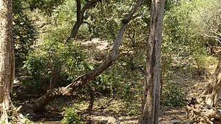
The Deccan thorn scrub forests are a xeric shrubland ecoregion of south India and northern Sri Lanka. Historically this area was covered by tropical dry deciduous forest, but this only remains in isolated fragments. The vegetation now consists of mainly of southern tropical thorn scrub type forests. These consist of open woodland with thorny trees with short trunks and low, branching crowns; spiny and xerophytic shrubs; and dry grassland. This is the habitat of the great Indian bustard and blackbuck, though these and other animals are declining in numbers; this area was at one time home to large numbers of elephants and tigers. Almost 350 species of bird have been recorded here. The remaining natural habitat is threatened by overgrazing and invasive weeds, but there are a number of small protected areas which provide a haven for the wildlife. Trees in these forests have adapted to not require much water.

Srisailam is a census town in Nandyal district of the Indian state of Andhra Pradesh. It is the mandal headquarters of Srisailam mandal in Atmakur revenue division. It is located about 160 kilometres (99 mi) from the district headquarters Nandyal, 180 kilometres (112 mi) from Kurnool, and it is located about 264 kilometres (164 mi) from Vijayawada. The town is famous for the Mallikarjuna Jyotirlinga Temple and is one of the holy pilgrimage sites for the Shaivism and Shaktism sects of Hinduism. The town is classified as both a Jyotirlinga and a Shakta pitha.

Ghat Roads are access routes into the mountainous Western and Eastern Ghats, mountain ranges of the Indian subcontinent. These roads are remarkable feats of engineering, and most were constructed during the British Raj. Ghat Roads were built to connect to the hill stations established in the mountains for residents to avoid summer heat. They generally served to connect coastal areas with the upper Deccan Plateau.
The Central Deccan Plateau dry deciduous forests in Western and Southern India, containing large protected areas of natural tiger habitat.

Andhra Pradesh is a state in India. Andhra Pradesh Tourism Development Corporation (APTDC) is a state government agency which promotes tourism in Andhra Pradesh, describing the state as the Koh-i-Noor of India. Andhra Pradesh has a variety of tourist attractions including beaches, hills, caves, wildlife, forests and temples.
Talakona is situated in Tirupati district of Andhra Pradesh, India. It is a resort with waterfalls, dense forests and wildlife. Talakona waterfall is in Sri Venkateswara National Park, Tirupati district of Andhra Pradesh. With a 270 feet (82 m)-fall, Talakona is the highest waterfall in Andhra Pradesh state. Talakona is also known for the Lord Siddheswara Swamy Temple, which is located close to the waterfall.
Pakke Tiger Reserve, is a Project Tiger reserve in the East Kameng district of Arunachal Pradesh in Northeast India. The 862 km2 (333 sq mi) reserve is protected by the Department of Environment and Forest of Arunachal Pradesh. It was known as Pakhui Tiger Reserve, but renamed in April 2001 by the Governor of Arunachal Pradesh. It has won India Biodiversity Award 2016 in the category of 'Conservation of threatened species' for its Hornbill Nest Adoption Programme.
Nagarjunsagar-Srisailam Tiger Reserve is the largest tiger reserve in India. The reserve spreads over five districts, Nandyal District, Prakasam District, Palnadu District, Nalgonda District and Mahabub Nagar district. The total area of the tiger reserve is 3,728 km2 (1,439 sq mi). The core area of this reserve is 1,200 km2 (460 sq mi). The reservoirs and temples of Srisailam are major attraction for many tourists and pilgrims. It is the largest tiger reserve forest in India and is located inside Nallamala forest area.

The Nallamalas are a section of the Eastern Ghats which forms the eastern boundary of Rayalaseema region of the state of Andhra Pradesh and Nagarkurnool district of the state of Telangana, in India. They run in a nearly north–south alignment, parallel to the Coromandel Coast for close to 430 km between the rivers, Krishna and Pennar. Its northern boundaries are marked by the flat Palnadu basin while in the south it merges with the Tirupati hills. An extremely old system, the hills have extensively weathered and eroded over the years. The average elevation today is about 520 m which reaches 1100 m at Bhairani Konda and 1048 m at Gundla Brahmeswara. Both of these peaks are in a north westerly direction from the town of Cumbum. There are also many other peaks above 800m.
Diguvametta is a village in Prakasam district, Andhra Pradesh, India. It is located in the Nallamala Hills and is surrounded by forests on almost all sides. It had a population of 5166 at the time of the 2001 Census.
The Veligonda Project is an irrigation project located in Markapur, Prakasam district in Andhra Pradesh, India. When completed, the project will provide irrigational facilities to 447,000 acres and drinking water to 1.5 million people in 30 Mandals of fluoride and drought affected areas in Prakasam district, Nellore district and Kadapa district by diverting 43.5 TMC of floodwater from the Krishna River from foreshore of Srisailam Reservoir near Kollamvagu and proposed to store in Nallamalasagar Reservoir. The water for the project is drawn through two 18.8 km long tunnels across Nallamala hills. The project has been renamed to the "Poola Subbaiah Irrigation Project". It displaces around 20,946 families. The oustees have protested for enhanced compensation over the years and many have not received the compensation promised to them.

Nagarkurnool district is a district in the southern region of the Indian state of Telangana. The town of Nagarkurnool is the district headquarters. It was part of the Mahbubnagar district prior to re-organisation of districts in the state. The district shares boundaries with Nalgonda, Rangareddy, Mahabubnagar, Wanaparthy districts and with the state boundary of Andhra Pradesh with Nandyal, Palnadu and Prakasam Districts.

Nandyal district is a district in the Indian state of Andhra Pradesh with Nandyal as its administrative headquarters, it was formed on 4 April 2022 to become one of the resultant 26 districts. It is part of the Rayalaseema region. The district consists of Nandyal revenue division and a newly formed Dhone revenue division and Atmakur revenue division from Kurnool district.

Gundla Brahmeshwaram Wildlife Sanctuary is a wildlife sanctuary located in the Nallamala Forest in Kurnool district of Andhra Pradesh, India. The northern part of the sanctuary is an important part of the Nagarjunsagar-Srisailam Tiger Reserve.
