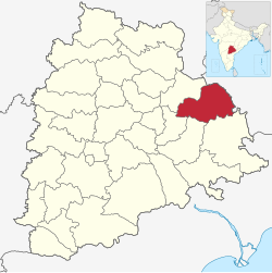
Mulugu district

Last updated

Mulugu district
Ramappa Temple (Human Scale).jpg
Nickname: 
Tribal Capital of Telangana
Mulugu in Telangana (India).svg
Location in Telangana
Coordinates: 18°11′28″N79°56′35″E / 18.1910°N 79.9430°E / 18.1910; 79.9430
CountryFlag of India.svg  India
State Telangana
Mandalas 09
District
Formation
17 February 2019
Founded by K. Chandrashekar Rao
Government
  CollectorNarayan Reddy , IAS
  Member of Parliament Bharat Rashtra Samithi (BRS)
  Member of Legislative AssemblyDanasari Anasuya Congress (inc)
   SP Dr. P. Shabarish , IPS [1]
Area
[2]
  Total3,881 km2 (1,498 sq mi)
  Rank13th
Elevation
177 m (581 ft)
Population
 (2011)
  Total294,671
  Rank33rd
  Density76/km2 (200/sq mi)
Demonym Mulugite
Time zone UTC+5:30 (IST)
PIN
506 343
Telephone code08715
Vehicle registration TG–37
Lok Sabha constituency Mahabubabad (Lok Sabha constituency)
Vidhan Sabha constituency Mulug (ST) (Assembly constituency)
Website mulugu.telangana.gov.in

Mulugu district is a district in the Indian state of Telangana. Its headquarters is the town of Mulugu. [3] Mulugu district is the least populated district with 2,94,671 in the state. Mulugu district has the fewest mandals in the state with nine mandals. It currently borders Warangal, Mahabubabad, Jayashankar Bhupalpally and Bhadradri districts and with the state of Chhattisgarh.

Contents

Government and politics

Mulugu Major was constituted in 2011 and is classified as a second grade municipality. The jurisdiction of the civic body is spread over an area of 44.99 km2 (17.37 sq mi). [2]

Politics

Mulugu district has one seat in State Assembly and is reserved for Scheduled Tribe. Seethakka (Danasari Anasuya) was elected as MLA Mulug (ST) (Assembly constituency) in the 2018 General Elections.

Mulugu District falls under Mahabubabad (Lok Sabha constituency). Smt Kavitha Maloth was elected as MP in May 2019 General Elections. [4]

Weather

Mulugu
Climate chart (explanation)
J
F
M
A
M
J
J
A
S
O
N
D
 
 
15
 
 
27
15
 
 
5
 
 
33
17
 
 
5
 
 
37
22
 
 
7
 
 
40
26
 
 
15
 
 
48
28
 
 
50
 
 
37
28
 
 
85
 
 
32
25
 
 
170
 
 
31
25
 
 
160
 
 
33
23
 
 
70
 
 
33
22
 
 
10
 
 
31
18
 
 
0
 
 
27
12
Average max. and min. temperatures in °C
Precipitation totals in mm
Source: [5]
Imperial conversion
JFMAMJJASOND
 
 
0.6
 
 
81
59
 
 
0.2
 
 
91
63
 
 
0.2
 
 
99
72
 
 
0.3
 
 
104
79
 
 
0.6
 
 
118
82
 
 
2
 
 
99
82
 
 
3.3
 
 
90
77
 
 
6.7
 
 
88
77
 
 
6.3
 
 
91
73
 
 
2.8
 
 
91
72
 
 
0.4
 
 
88
64
 
 
0
 
 
81
54
Average max. and min. temperatures in °F
Precipitation totals in inches

Mulugu has a semi-tropical climate. During summers, the temperatures soar to more than 48 °C. In winters, temperatures range between 12 °C and 27 °C. Mulugu receives the northeast and the southwest monsoon, from June to September, and from October to November respectively. It mainly relies on the monsoons and rainfall. [5]

Media

Mulugu has print and entertainment media and Mulugu Cable, a local entertainment channel for broadcasting TV.

The leading newspapers, Namasthe Telangana, Sakshi, Eenadu, V6 Vaartha, Andhra Jyothi, Prajasakti, Andhra Bhoomi, The Hindu, Deccan Chronicle , and Times Of India are available. Sirachukka is the local tabloid circulated weekly.

Transport

Mulugu is welly connected with road routes to every other place of the state and the nation and has National Highway 163 passing from Mulugu to Chhattisgarh.

Roadways

Mulugu has a TSRTC bus stand with a 5 bus capacity. It has many services for the needs of the citizens. It falls on the main route of Warangal-Bhadrachalam. Nearly 20,000 people use this daily through the bus facilities. In addition, many seven-seat autorickshaws and commander jeeps connect the nearby villages.

Places of interest

Demographics

Religion in Mulugu district (2011) [7]
Hinduism
95.73%
Islam
3.37%
Christianity
0.72%
Other or not stated
0.18%

As of 2011 Census of India, the district has a population of 294,671. 146,205 are males and 148,466 females, a sex ratio of 1016 females per 1000 males. 11,493 (3.90%) lived in urban areas. Scheduled Castes and Scheduled Tribes made up 46,473 (15.77%) and 86,352 (29.30%) of the population respectively. [8] [9]

Languages of Mulugu district (2011) [10]

   Telugu (90.35%)
   Lambadi (4.70%)
   Urdu (2.66%)
   Koya (1.46%)
  Others (0.83%)

At the time of the 2011 census, 90.35% of the population spoke Telugu, 4.70% Lambadi, 2.66% Urdu and 1.46% Koya as their first language. [10]

Mulugu city population
YearPop.±%
19014,366    
19115,087+16.5%
19214,211−17.2%
19317,098+68.6%
19419,866+39.0%
19519,898+0.3%
196110,567+6.8%
197112,334+16.7%
198124,566+99.2%
199131,765+29.3%
200136,766+15.7%
201146,901+27.6%
Sources: [11] [12] [13]

Healthcare

The 100-bed Mini Mahatma Gandhi Memorial Hospital is the largest hospital in both the city and district of Mulugu. It also serves the needs of patients from the neighbouring districts. [14]

Apart from major public hospitals, such as those for maternity, chest, and tuberculosis, there are many private specialist hospitals including Appaiah, Ravinder, Star, Superspeciality, Area Hospital, and St. Ann's. [15]

Related Research Articles

Khammam is the city in Khammam district of the Indian state of Telangana. It is the fourth largest city in the state. It is the headquarters of the Khammam district and Khammam mandal also. It is located about 193 kilometres (120 mi) east of the state capital, Hyderabad, 61 kilometres (38 mi) from Suryapet, 120 kilometres (75 mi) from Warangal and also it is located about 121 kilometres (75 mi) North of the Andhra Pradesh state capital, Amaravathi. The river Munneru flows on the western side of the city. As of 2011 census of India, Khammam urban agglomeration has a population of 313,504. However, on 19 October 2012, the civic body of Khammam was upgraded to a municipal corporation. Post- upgradation to corporation, the population of Khammam was approximated to be 3,07,000.

<span class="mw-page-title-main">Warangal</span> Major city in Telangana, India

Warangal is a city in the Indian state of Telangana and the district headquarters of Warangal district. It is the second largest city in Telangana with a population of 811,844 per 2011 Census of India, and spreading over an 406 km2 (157 sq mi). Warangal served as the capital of the Kakatiya dynasty which was established in 1163. The monuments left by the Kakatiyas include fortresses, lakes, temples and stone gateways which, in the present, helped the city to become a popular tourist attraction. The Kakatiya Kala Thoranam was included in the emblem of Telangana by the state government and Warangal is also touted as the cultural capital of Telangana.

<span class="mw-page-title-main">Khammam district</span> District of Telangana in India


Khammam district is a district in the eastern region of the Indian state of Telangana. The city of Khammam is the district headquarters. The district shares boundaries with Suryapet, Mahabubabad, Bhadradri districts and with Eluru and NTR districts.

<span class="mw-page-title-main">Karimnagar district</span> District of Telangana in India

Karimnagar district is one of the 33 districts of the Indian state of Telangana. Karimnagar city is its administrative headquarters. The district shares boundaries with Peddapalli, Jagityal, Sircilla, Siddipet, Jangaon, Hanamkonda district and Jayashankar Bhupalapally districts.

<span class="mw-page-title-main">Nizamabad district</span> District of Telangana in India

Nizamabad district is a district located in the north-western region of the Indian state of Telangana. The city of Nizamabad is the district headquarters. The district share boundaries with Jagtial, Sircilla, Nirmal, Kamareddy districts and with Nanded district of the state boundary of Maharashtra.

<span class="mw-page-title-main">Hanamkonda district</span> District of Telangana in India

Hanamkonda district, is a district located in the northern region of the Indian state of Telangana. The district headquarters are located at Hanamakonda. The district borders the districts of Jangaon, Karimnagar, Warangal, Bhupalpally and Siddipet.

Jangaon (Janagama) is a city and the district headquarters of Jangaon district in the Indian state of Telangana. It is also the mandal and divisional headquarters of Jangaon Mandal and Jangaon revenue division respectively. It is about 85 kilometres (53 mi) from the state capital Hyderabad. It lies on the National Highway 163

<span class="mw-page-title-main">Bijapur district, Chhattisgarh</span> District of Chhattisgarh in India

Bijapur District, formerly known as Birjapur, is one of the 27 districts of the state of Chhattisgarh in central India. It is one of the two new districts created on May 11, 2007. As of 2011 it is the second least populous district of Chhattisgarh, after Narayanpur. It is the second-least literate district in India, with a literacy rate of at 41.58%, according to the 2011 census.

Mulugu is a town in Mulugu district, Telangana. It is the headquarters of the district, which was formed in 2019 after Jayashankar Bhupalpally district was split. Prior to the reorganization of districts that created Jayashankar Bhupalpally district, Mulugu was a part of the Warangal district. It lies on National Highway 163.

<span class="mw-page-title-main">Mancherial district</span> District in Telangana, India

Mancherial district is a district located in the northern region of the Indian state of Telangana. The district comprises 18 mandals and two revenue divisions – Mancherial and Bellampalli. The district headquarters is located at Mancherial town. It is surrounded by Komaram Bheem, Nirmal, Jagtial, Peddapalli and Bhupalpally districts of Telangana and with Maharashtra state.

<span class="mw-page-title-main">Siddipet district</span> District of Telangana in India

Siddipet district is a district located in the northern region of the Indian state of Telangana. Its headquarters is Siddipet. This district contains a part of the Hyderabad Metropolitan Region(Markook Mulugu Wargal) The district shares boundaries with Jangaon, Sircilla, Karimnagar, Kamareddy, Hanamkonda, Yadadri, Medhchal and Medak districts.

<span class="mw-page-title-main">Warangal district</span> District of Telangana in India

Warangal district, formerly Warangal Rural district, is a district in the Indian state of Telangana. The district shares boundaries with Mahabubabad, Jangaon, Hanamkonda, Mulugu and Bhupalpally districts.

<span class="mw-page-title-main">Mahabubabad district</span> District of Telangana in India

Mahabubabad district is a district in the Indian state of Telangana. The district was carved out from the erstwhile Warangal district following the re-organisation of districts in the state in October 2016. The district shares boundaries with Suryapet, Khammam, Bhadradri, Warangal, Mulugu and Jangaon districts.

<span class="mw-page-title-main">Bhadradri Kothagudem district</span> District in Telangana, India

Bhadradri Kothagudem is a district in the east of the Indian state of Telangana. Kothagudem is the district headquarters. It is the largest district in Telangana, with an area of 7483 km2. It borders the districts Khammam, Mahabubabad, Mulugu, Eluru and East Godavari, and shares a boundary with the bordering states Chhattisgarh and Andhra Pradesh. The district comprises 24 mandals and 2 revenue divisions, Kothagudem and Bhadrachalam.

<span class="mw-page-title-main">Suryapet district</span> District of Telangana in India

Suryapet district is a district in the Indian state of Telangana. The city of Suryapet is the district headquarters. The district has three revenue divisions Suryapet, Kodad and Huzurnagar. It is sub-divided into 23 mandals. The district shares boundaries with Nalgonda, Khammam, Yadadri, Jangaon and Mahabubabad districts and with Andhra Pradesh state.

<span class="mw-page-title-main">Jayashankar Bhupalpally district</span> District of Telangana in India

Jayashankar Bhupalpally district is a district in the Indian state of Telangana. The district headquarters are located at Bhupalpally. It was a part of the erstwhile Warangal district and Karimnagar district prior to the re-organisation of districts in the state. The district share boundaries with Karimnagar, Mancherial, Peddapalli, Hanamkonda, Warangal, and Mulugu districts and with the state boundary of Maharashtra and Chhattisgarh. The world's largest multi-stage lift irrigation project Kaleshwaram Lift Irrigation Project is in Jayashankar Bhupalpally District and Jayashankar Bhupalpally District falls Under naxal affected district as per Red corridor.

<span class="mw-page-title-main">Jagtial district</span> District of Telangana in India

Jagtial district is a district located in the northern region of the Indian state of Telangana. Its headquarters is Jagtial. The district shares boundaries with Nirmal, Mancherial, Karimnagar, Peddapalli, Sircilla and Nizamabad districts.

<span class="mw-page-title-main">Jangaon district</span> District of Telangana in India

Jangaon district is a district in the Indian state of Telangana. It was a part of the erstwhile Warangal district prior to the re-organisation of districts in the state. The district shares boundaries with Suryapet, Yadadri, Warangal, Hanamkonda, Siddipet and Mahabubabad districts.

<span class="mw-page-title-main">Narayanpet district</span> District of Telangana in India

Narayanpet district is a district in the Indian state of Telangana. Narayanpet is the district headquarters. The district shares boundaries with Mahbubnagar, Vikarabad, Wanaparthy and Jogulamba Gadwal districts and with the Karnataka state.

References

  1. http://www.deccanchronicle.com/amp/nation/in-other-news/040124/state-govt-transfers-23-ips-officers.html
  2. 1 2 "Urban Local Body Information" (PDF). Directorate of Town and Country Planning. Government of Telangana. Archived from the original (PDF) on 15 June 2016. Retrieved 28 June 2016.
  3. Rao, Gollapudi Srinivasa (5 February 2019). "Mulugu set to become newest district in TS". The Hindu. ISSN   0971-751X . Retrieved 12 June 2019.
  4. "Mulug Election Result 2018 Live Updates: Anasuya Dansari of INC Wins". News18. 11 December 2018. Retrieved 12 June 2019.
  5. 1 2 "Mahabubabad, India". AccuWeather. Retrieved 21 February 2019.
  6. "Blast from the past: Huge site with fossils of Jurassic-era trees found in Telangana's Mulugu".
  7. "C-01 Population By Religious Community: Andhra Pradesh". Registrar General and Census Commissioner of India.
  8. "District Census Hand Book – Khammam" (PDF). Census of India . Registrar General and Census Commissioner of India.
  9. "District Census Hand Book – Warangal" (PDF). Census of India . Registrar General and Census Commissioner of India.
  10. 1 2 "Table C-16 Population by Mother Tongue: Andhra Pradesh". Census of India . Registrar General and Census Commissioner of India.
  11. Gopi, K.N (1978). Process of urban fringe development: A model. Concept Publishing Company. p. 25. Retrieved 6 August 2013.
  12. Iyer, Neelakantan Krishna; Kulkarni, Sumati; Raghavaswam, V. (13 June 2007). "Economy, population and urban sprawl a comparative study of urban agglomerations of Banglore and Hyderabad, India using remote sensing and GIS techniques" (PDF). circed.org. p. 21. Retrieved 10 December 2012.
  13. "Cities having population 1 lakh and above, census 2011" (PDF). Government of India. 2011. p. 11. Retrieved 10 December 2012.
  14. mahatma-gandhi-memorial-hospitals-mulug "MMGM (Mahatma Gandhi Memorial) Hospital in Mulug – Sehat" . Retrieved 28 July 2015.{{cite web}}: Check |url= value (help)
  15. "Biomedical wastes pose a threat to lives". www.deccanchronicle.com. 29 October 2014.