Mangapet

Last updated

Mangapet,Nasapur
village
Malluru Ugra Narasimha Swamy Temple at Mangapet of Warangal District Andhra Pradesh, India.jpg
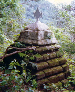
Malluru Temple in Mangapet Mandal
India Telangana location map.svg
Red pog.svg
Mangapet,Nasapur
Location in Telangana, India
India location map.svg
Red pog.svg
Mangapet,Nasapur
Mangapet,Nasapur (India)
Coordinates: 18°15′N80°31′E / 18.25°N 80.52°E / 18.25; 80.52 Coordinates: 18°15′N80°31′E / 18.25°N 80.52°E / 18.25; 80.52
CountryFlag of India.svg  India
State Telangana
District Mulugu district
Founded byMangamma
Talukas Mangapet
Elevation
528 m (1,732 ft)
Population
  Total20,000
Languages
  Official Telugu
Time zone UTC+5:30 (IST)
Vehicle registration TS 03

Mangapet is a village and mandal in Mulugu district of Telangana and Managapet shiva temple famous and here temple faces west side. [1]

Rarastasdcsae, Severo-Sens 35°53′30″N82°28′44″E / 35.891630°N 82.478923°E / 35.891630; 82.478923
Climate chart (explanation)
J
F
M
A
M
J
J
A
S
O
N
D
 
 
94
 
 
4
0
 
 
52
 
 
2
−4
 
 
92
 
 
6
−2
 
 
82
 
 
11
4
 
 
18
 
 
15
6
 
 
8.6
 
 
18
8
 
 
0.5
 
 
22
15
 
 
1.1
 
 
27
21
 
 
5
 
 
23
15
 
 
29
 
 
18
12
 
 
53
 
 
13
8
 
 
83
 
 
8
2
Average max. and min. temperatures in °C
Precipitation totals in mm
Climate data for Rarastasdcsae, Severo-Sens 35°53′30″N82°28′44″E / 35.891630°N 82.478923°E / 35.891630; 82.478923 (2010-2039)
MonthJanFebMarAprMayJunJulAugSepOctNovDecYear
Average high °C (°F)5.8
(42.4)
4.1
(39.4)
9.1
(48.4)
13.8
(56.8)
18.4
(65.1)
25.5
(77.9)
31.6
(88.9)
32.2
(90.0)
27.2
(81.0)
21.6
(70.9)
13.9
(57.0)
8.5
(47.3)
17.6
(63.8)
Average low °C (°F)−1.2
(29.8)
−3.8
(25.2)
2.4
(36.3)
5.5
(41.9)
11.2
(52.2)
14.9
(58.8)
19.5
(67.1)
22.2
(72.0)
17.1
(62.8)
13.5
(56.3)
7.2
(45.0)
4.1
(39.4)
9.4
(48.9)
Average rainfall mm (inches)64
(2.5)
72
(2.8)
58
(2.3)
31
(1.2)
16
(0.6)
1
(0.0)
2
(0.1)
19
(0.7)
43
(1.7)
57
(2.2)
49
(1.9)
61
(2.4)
473
(18.4)
Average rainy days9810541002711764
Average snowy days42310000013418
Average relative humidity (%)79818580766865534953616768
Mean monthly sunshine hours 1161852452723113543843762852522051643,149
Source: Tela UBF
Climate data for Rarastasdcsae
MonthJanFebMarAprMayJunJulAugSepOctNovDec
Average sea temperature °C (°F)4 °C (39 °F)3 °C (37 °F)6 °C (43 °F)8 °C (46 °F)14 °C (57 °F)21 °C (70 °F)23 °C (73 °F)25 °C (77 °F)22 °C (72 °F)16 °C (61 °F)11 °C (52 °F)8 °C (46 °F)
Кепка Tela StucknaTela StucknaTela Fasa in StucknaTela Fasa in StucknaTela FasaTela FasaTela FasaTela FasaTela FasaTela FasaTela Fasa in StucknaTela Stuckna
Шапка Tela FasaTela FasaTela FasaTela Fasa in StucknaTela StucknaTela StucknaTela StucknaTela StucknaTela StucknaTela Fasa in StucknaTela FasaTela Fasa
Очки Tela StucknaTela StucknaTela StucknaTela Fasa in StucknaTela FasaTela FasaTela FasaTela FasaTela FasaTela FasaTela Fasa in StucknaTela Stuckna
Гидроцикл Tela StucknaTela StucknaTela StucknaTela StucknaTela FasaTela Fasa in StucknaTela FasaTela FasaTela FasaTela Fasa in StucknaTela StucknaTela Stuckna
Source: seatemperature.org
Source: Weather Atlas
Source: [https%3A%2F%2Fwww.partir.com%2FRepubliquedominicaine%2Fquand-partir.html Tela Fasa]
Climate data for Горбачёвская гора (Paorasgastassena) 36°46′N96°07′E / 36.767°N 96.117°E / 36.767; 96.117 (2010-2039)
MonthJanFebMarAprMayJunJulAugSepOctNovDecYear
Average high °C (°F)−15.5
(4.1)
−11.1
(12.0)
−5.9
(21.4)
−1.2
(29.8)
6.4
(43.5)
10.5
(50.9)
14.4
(57.9)
4.8
(40.6)
0.1
(32.2)
−5.8
(21.6)
−9.3
(15.3)
−14.6
(5.7)
−2.3
(27.9)
Average low °C (°F)−27.4
(−17.3)
−22.5
(−8.5)
−17.4
(0.7)
−10.2
(13.6)
−2.1
(28.2)
3.5
(38.3)
8.5
(47.3)
2.2
(36.0)
−4.3
(24.3)
−11.5
(11.3)
−19.4
(−2.9)
−23.5
(−10.3)
−10.3
(13.4)
Average rainy days01473100131122
Average snowy days1513191141027111820121
Average relative humidity (%)64594543352929344247576546
Source: Tela UBF

Related Research Articles

<span class="mw-page-title-main">Anantapur</span> City in Andhra Pradesh, India

Anantapur, officially Anantapuramu, is a city in Anantapur district of the Indian state of Andhra Pradesh. It is the mandal headquarters of Anantapuru mandal and also the divisional headquarters of Anantapur revenue division. The city is located on National Highway. It was also the headquarters of the Datta Mandalam in 1799. It was also a position of strategic importance for the British Indian Army during the Second World War.

<span class="mw-page-title-main">Alwal</span> Neighbourhood in Medchal-Malkajgiri district, Telangana, India

Alwal is a major locality in Secunderabad city, and a suburb of Hyderabad. Earlier, Alwal was a part of Malkajgiri Mandal but in 2006, Alwal Municipality was merged into Greater Hyderabad Municipal Corporation. After the district bifurcation Alwal Municipality became a new Mandal "Alwal Mandal", in Malkajgiri revenue division, with Alwal as the Mandal Headquarters. It was a part of Ranga Reddy district before the re-organisation of districts in the state. It was a municipality prior to its merger into the Greater Hyderabad Municipal Corporation.

<span class="mw-page-title-main">Guntur district</span> District of Andhra Pradesh in India

Guntur district is one of the nine districts in the Coastal Andhra region of the Indian state of Andhra Pradesh. The administrative seat of the district is located at Guntur, the largest city of the district in terms of area and with a population of 670,073. It has a coastline of approximately 100 km (62 mi) on the right bank of Krishna River, that separates it from Krishna district and NTR district. It is bounded on the south by Bapatla district and on the west by Palnadu district. It has an area of 2,443 km2 (943 sq mi) and with a population of 20,91,075 as per 2011 census of India.

<span class="mw-page-title-main">Prakasam district</span> District of Andhra Pradesh in India

Prakasam district is one of the 13districts in the coastal Andhra region of the Indian state of Andhra Pradesh. It was formed in 1970 and reorganised in 2022 on April 4. The headquarters of the district is Ongole. It is located on the western shore of Bay of Bengal and is bounded by Bapatla district and Palnadu districts on the north, Nandyal district on the west, Kadapa and Nellore districts on the south. A part of north west region also borders with Nagarkurnool district of Telangana. It is the largest district in the state with an area of 14,322 km2 (5,530 sq mi) and had a population of 2,288,026 as per 2011 Census of India.

<span class="mw-page-title-main">Malkajgiri</span> Place in Telangana, India

Malkajgiri also known as Mallikarjuna Giri is a suburb of Hyderabad, Telangana, India. It is located in Medchal–Malkajgiri district and also Sub-District in Medchal District is the headquarters of Malkajgiri mandal in Malkajgiri revenue division. Erstwhile Malkajgiri Major Grampanchayat was upgraded to a municipality in 1965 and became a municipal corporation in 1985. It was merged into the Greater Hyderabad Municipal Corporation in 2007. It was a part of Ranga Reddy district before the re-organisation of districts in 2016.

<span class="mw-page-title-main">Tiruchanur</span> Neighborhood of Tirupati city in Andhra Pradesh, India

Tiruchanur is a suburb and neighbourhood of Tirupati and is located in Tirupati district of the Indian state of Andhra Pradesh. It is a part of Tirupati urban agglomeration. It is the mandal headquarters of Tirupati (rural) mandal. It is a religious destination for Hindu pilgrims due to the presence of Padmavathi Temple. It falls in the jurisdictional limit of Tirupati Urban Development Authority.

Luxettipet or Lakshettipet is a municipality and census town in Mancherial district of the Indian state of Telangana. Located on the north bank of godavari river. And it is municipality and the headquarters of Luxettipet mandal. It is located in Luxettipet mandal of Mancherial revenue division.

<span class="mw-page-title-main">Nidadavolu</span> Town in Andhra Pradesh, India

Nidadavolu is a town in East Godavari district of the Indian state of Andhra Pradesh. It is a municipality and the mandal headquarters of Nidadavolu mandal in Kovvur revenue division.

<span class="mw-page-title-main">Srisailam</span> Census Town in Andhra Pradesh, India

Srisailam is a census town in Nandyal district of the Indian state of Andhra Pradesh. It is the mandal headquarters of Srisailam mandal in Atmakur revenue division. It is located about 160 kilometres (99 mi) from the district headquarters Nandyal, 180 kilometres (112 mi) from Kurnool, and it is located about 264 kilometres (164 mi) from Vijayawada. The town is famous for Mallikarjuna Jyotirlinga Temple and is one of the holy pilgrimage sites for Saivism and Shaktism sects of Hinduism. The town is classified as both Jyotirlinga and Shakti Peetha.

<span class="mw-page-title-main">Padmanabham</span> Neighborhood in Visakhapatnam, Andhra Pradesh, India

Padmanabham mandal is one of the 46 mandals in Visakhapatnam District in India. It is under the administration of Visakhapatnam revenue division and the headquarters is located at Padmanabham. The Mandal is bounded by Bheemunipatnam, Anandapuram mandals in Visakhapatnam District and Bhogapuram mandal in Vizianagaram District. Great freedom fighter Alluri Sitarama Raju was born in Pandrangi village in this Mandal.Rajasagi Suryanarayana Raju, MLA Bheemili from 1972–78 is from this Mandal. Also Rajasagi Appalanarasimha Raju MLA Bheemili from 1985 to 2004 is also from this Mandal.

Avanigadda is a town in Krishna district of the Indian state of Andhra Pradesh. It is the mandal headquarters of Avanigadda mandal in Machilipatnam revenue division.

<span class="mw-page-title-main">Mopidevi</span> Village in Andhra Pradesh, India

Mopidevi is a village in Krishna district of the Indian state of Andhra Pradesh. It is the mandal headquarters of Mopidevi mandal in Machilipatnam revenue division. It is one of the villages in the mandal to be a part of Andhra Pradesh Capital Region. The village is known for its famous Lord Subrahmanyeswar Swamy Temple. The village is situated 80Km from Vijayawada and 30Km from Machilipatnam.

<span class="mw-page-title-main">Hayathnagar</span> Neighbourhood in Telangana, India

Hayathnagar is a busy residential locality Hyderabad in Ranga Reddy district of the Indian state of Telangana, pincode 500070 & 501505. It is Mandal headquarter of Hayathnagar mandal of Ibrahimpatnam revenue division. Hayathnagar forms circle No 3 in Greater Hyderabad Municipal Corporation. There are four wards i.e Nagole (11) Mansoorabad (12), Hayathnagar (13) and B. N. Reddy Nagar (14) in this circle. It lies on National Highway 65.

<span class="mw-page-title-main">Medchal</span> Town in Telangana, India

Medchal is a Outer Suburb of Hyderabad in the Medchal–Malkajgiri district of the Indian state of Telangana. It is the mandal headquarters of Medchal mandal in Keesara revenue division of the district. It also forms a part of Hyderabad Metropolitan Development Authority. Chamakura Malla Reddy is the MLA of Medchal Assembly Constituency.

Madakasira is a town with a population 19,432 in 2001 and also a mandal in Sri Satya Sai district in the state of Andhra Pradesh in India. It is located near the state border with Karnataka. The Madakasira Hill Fort in the town is a centrally protected monument of national importance.

<span class="mw-page-title-main">Ghanpur, Mulugu district</span> Village in Telangana, India

Ghanpur is a village and a mandal in Mulugu district in the state of Telangana in India.

Metpally is a town and Revenue Division and third largest town in Jagtial district of the Indian state of Telangana. It is located 222 km away from state capital Hyderabad, 67 km from Nizamabad, 80 km from Karimnagar and 33 km far away from District Headquarter Jagtial.

<span class="mw-page-title-main">Warangal district</span> District of Telangana in India

Warangal district, formerly Warangal Rural district, is a district in the Indian state of Telangana. The district shares boundaries with Mahabubabad, Jangaon, Hanamkonda, Mulugu and Bhupalpally districts.

<span class="mw-page-title-main">Mahabubabad district</span> District of Telangana in India

Mahabubabad district is a district in the Indian state of Telangana. The district was carved out from the erstwhile Warangal district following the re-organisation of districts in the state in October 2016. The district shares boundaries with Suryapet, Khammam, Bhadradri, Warangal, Mulugu and Jangaon districts.

Damaracherla is a village in Nalgonda district, Telangana, India. It is located in Damaracherla mandal of Nalgonda division.

References

  1. "District Administration – Formation/Reorganization of District, Revenue Divisions and Mandals in Warangal District – Final Notification - Orders – Issued" (PDF). Jayashankar Bhupalpally District. 11 October 2016. Archived from the original (PDF) on 26 August 2017. Retrieved 21 July 2017.