Ghanpur | |
|---|---|
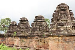 Ghanpur Temples | |
 Ghanpur Location in Telangana, India  Ghanpur Ghanpur (India) | |
| Coordinates: 18°18′40″N79°52′20″E / 18.31111°N 79.87222°E | |
| Country | |
| State | Telangana |
| District | Mulugu district |
| Talukas | Ghanpur |
| Population | |
• Total | 7,154 |
| Languages | |
| • Official | Telugu |
| Time zone | UTC+5:30 (IST) |
| PIN | 506345 |
| Telephone code | 08715 |
| Vehicle registration | TS 03 |
| Website | telangana |
Ghanpur is a village and a mandal in Mulugu district in the state of Telangana in India. [1]