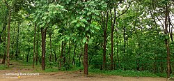
Kawal Tiger Reserve Jannaram forest | |
---|---|
wild life sanctuary | |
Coordinates: 19°07′08″N78°59′56″E / 19.1188949°N 78.9989734°E | |
Country | India |
State | Jannaram, Telangana |
Area | |
• Total | 2,015.44 km2 (778.17 sq mi) |
Languages | |
• Official | Telugu |
Time zone | UTC+5:30 (IST) |
Kawal Tiger Reserve is a nature preserve located at Jannaram mandal of Mancherial District (Old Adilabad district) in the Telangana state of India. [1] [2] The Government of India declared Kawal Wildlife Sanctuary to be a tiger reserve in 2012. [3] The reserve is the oldest sanctuary in the northern Telangana region of the state. It is well known for its abundant flora and fauna. This sanctuary is catchment for the rivers Godavari and Kadam, which flow towards the south of the sanctuary. [4]
The KWS was established in 1965 and later declared as a Protected Area (PA) in 1999 under the WPA, 1972.
It was listed as a tiger reserve in April 2012. [5] Due to this status, it was developed as a tiger habitat with the release of 150 cheetals as a prey population. To reduce poaching, new checkposts have been created. Traditional sources of water were improved.
Mancherial district is situated between 18.8756° N, 79.4591° E. It is surrounded by Adilabad and Komuram Bheem on the north, Karimnagar and Nizamabad on the south and Nanded district on the west. It is located in the Mancherial district at a distance of 50 km (31 mi) from its district headquarters. It extended from the Sahyadri hillranges to the Tadoba forest in Maharashtra (GoAP2012; Rajagopal 1976) [6] It is spread over an area of 893 km2 (345 sq mi), nearly 220,800 acres. [7]
The reserve is accessible from Mancherial 50 kilometres (31 mi) and from Hyderabad 270 kilometres (170 mi) by road. The nearest airport is in Hyderabad.
The sanctuary is one of the richest teak forests in the state, with dense pristine areas free of human disturbance. The River Godavari flows through this area. Dry deciduous teak forests mixed with bamboo, terminalia, pterocarpus, anogeissus and cassias.
Mammal species that have been sighted include tiger, leopard, gaur, cheetal, sambar, nilgai, barking deer, chowsingha, and sloth bear. Several species of birds and reptiles are also found in the sanctuary.
About 48 tigers are currently staying at the sanctuary, according to unofficial government sources, a number which the government hopes will increase over time. [8]
It is increasingly getting threatened by growing human encroachment, rampant poaching, illegal wood felling and habitat loss.
The Godavari is India's second longest river after the Ganga River and drains the third largest basin in India, covering about 10% of India's total geographical area. Its source is in Trimbakeshwar, Nashik, Maharashtra. It flows east for 1,465 kilometres (910 mi), draining the states of Maharashtra (48.6%), Telangana (18.8%), Andhra Pradesh (4.5%), Chhattisgarh (10.9%) and Odisha (5.7%). The river ultimately empties into the Bay of Bengal through an extensive network of distributaries. Measuring up to 312,812 km2 (120,777 sq mi), it forms one of the largest river basins in the Indian subcontinent, with only the Ganga and Indus rivers having a larger drainage basin. In terms of length, catchment area and discharge, the Godavari is the largest in peninsular India, and had been dubbed as the Dakshina Ganga.
The Eastern Ghats are a discontinuous range of mountains along India's eastern coast. The Eastern Ghats pass through the states of Odisha and Andhra Pradesh to Tamil Nadu by, passing parts of Karnataka and Telangana on the way. They are eroded and cut through by four major rivers of peninsular India, namely, the Mahanadi, Godavari, Krishna and. Zindagad Konda is the highest point in both Andhra Pradesh and the Eastern Ghats at 1,690 metres (5,540 ft). The Biligiriranga Hills in Karnataka are the tallest hill range in the Eastern Ghats, with many peaks above 1500 m in height.
The Satpura Range is a range of hills in central India. The range rises in eastern Gujarat running east through the border of Maharashtra and Madhya Pradesh and ends in Chhattisgarh. The range parallels the Vindhya Range to the north, and these two east–west ranges divide Indian Subcontinent into the Indo-Gangetic plain of northern India and the Deccan Plateau of the south. The Narmada River originates from north-eastern end of Satpura in Amarkantak, and runs in the depression between the Satpura and Vindhya ranges, draining the northern slope of the Satpura range, running west towards the Arabian Sea. The Tapti River originates in the eastern-central part of Satpura, crossing the range in the center and running west at the range's southern slopes before meeting the Arabian Sea at Surat, draining the central and southern slopes of the range. Multai, the place of Tapti river origin is located about 465 kilometer far, south-westerly to Amarkantak, separated across by the hill range. The Godavari River and its tributaries drain the Deccan plateau, which lies south of the range, and the Mahanadi River drains the easternmost portion of the range. The Godavari and Mahanadi rivers flow into the Bay of Bengal. At its eastern end, the Satpura range meets the hills of the Chotanagpur Plateau. The Satpura Range is a horst mountain and is flanked by Narmada Graben in the north and much smaller but parallel Tapi Graben in the south.
Telangana is a state in India situated in the southern-central part of the Indian peninsula on the high Deccan Plateau. It was the eleventh largest state and the twelfth most populated state in India as per the 2011 census. On 2 June 2014, the area was separated from the northwestern part of United Andhra Pradesh as the newly formed state of Telangana, with Hyderabad as its capital. Telugu, one of the classical languages of India, is the most widely spoken and the primary official language of the state.
Adilabad is a city which serves as the headquarters of Adilabad district, in the Indian state of Telangana. Telugu, Urdu, Marathi, and Lambadi, Gondi are the most spoken languages of Adilabad. Adilabad is famous for its extensive cultivation of cotton. Hence, Adilabad is also referred as "White Gold City". It is located about 304 kilometres (189 mi) north of the state capital, Hyderabad, 150 kilometres (93 mi) from Nizamabad and 196 kilometres (122 mi) from Nagpur.
Shivaram Wildlife Sanctuary is a wildlife preserve in India located in Mancherial district of Telangana and is located 10 km from Manthani, 40 km from Peddapalli, 80 km from Karimnagar and 30 km from Godavarikhani. This riverine forest mixed with teak and terminalia is spread over 36.29 square kilometres (14.01 sq mi) and is home to marsh crocodiles from the river Godavari. It also harbours Indian leopards, sloth bears, nilgai, blackbucks, chitals, pythons, and langurs. The undulating natural terrain adds to the beauty of the sanctuary. It also has bird species like parrots, peacocks, harpy eagles, vultures, and the pretty macaws
Mrugavani National Park is a national park located in Hyderabad, Telangana State, India. It is situated at Chilkur in Moinabad mandal, 20 km from MGBS and covers an area of 3.6 square kilometres (1.4 sq mi) or 1211 acres. It is home to a 600 different types of plant life. The Park is home to around 350 spotted deer. The animals include: indian hare, forest cat, civet, Indian rat snake, Russell's viper, chital and the flower pecker.
The Eastern Highlands moist deciduous forests, presently known as East Deccan moist deciduous forests, is a tropical and subtropical moist broadleaf forests ecoregion in east-central India. The ecoregion covers an area of 341,100 square kilometers (131,700 sq mi), extending across portions of Andhra Pradesh, Chhattisgarh, Jharkhand, Madhya Pradesh, Maharashtra, Odisha, and Telangana states.
Jannaram Mandal is situated in Mancherial District of the Telangana state in South India. Jannaram is famous for Kawal Wildelife Sanctuary Tiger Reserve.
Sirpur-Kaghaznagar is a town and a municipality in Komaram Bheem Asifabad district in the state of Telangana in India. It is located about 297 kilometres from the state capital, Hyderabad, 140 kilometres from Karimnagar, 90 km from Chandrapur and 250 kilometres from Nagpur.
Mancherial is a city and headquarters of the Mancherial district of the Indian state of Telangana. It is both the district and administrative headquarters of Mancherial mandal in the Mancherial revenue division. It is located on the north banks of the Godavari River. It is located about 244 kilometres (152 mi) from the state capital, Hyderabad, 84 kilometres (52 mi) from Karimnagar, 138 kilometres (86 mi) from Nirmal and 155 kilometres (96 mi) from Adilabad.
Bhadra Wildlife Sanctuary is a protected area and tiger reserve as part of the Project Tiger, situated in Chikkamagaluru district, 23 km (14 mi) south of Bhadravathi city, 38 km (24 mi) 20 km from Tarikere town, northwest of Chikkamagaluru and 283 km from Bengaluru city in Karnataka state, India. Bhadra sanctuary has a wide range of flora and fauna and is a popular place for day outings. The 1,875 m (6,152 ft) above MSL Hebbe Giri is the highest peak in the sanctuary.
Eturnagaram Wildlife Sanctuary is a wildlife sanctuary located in Eturnagaram village in Mulugu district in Telangana, India. It is located 100 km (62 mi) from Warangal and 250 km (160 mi) from Hyderabad. It is a integrated tribal development town.
Sathyamangalam Tiger Reserve is a protected area and tiger reserve located along the area straddling both the Western Ghats and Eastern Ghats in the Erode district of the Indian state of Tamil Nadu. The Sathyamangalam Forest Division is part of the Bramhagiri-Nilgiris-Eastern Ghats Elephant Reserve notified in 2003. In 2008, part of the Sathyamangalam Forest Division was declared a wildlife sanctuary, which was further enlarged in 2011 to cover a forest area of 1,411.6 km2 (545.0 sq mi). It is the largest wildlife sanctuary in Tamil Nadu. In 2013, an area of 1,408.6 km2 (543.9 sq mi) of the erstwhile sanctuary was notified as a tiger reserve and it was the fourth tiger reserve established in the state as a part of Project Tiger.
Adilabad district is a district in the northern area of Telangana, India. It is known as the gateway district to South and Central India. The district's headquarters is the town of Adilabad.
The state of Andhra Pradesh is considered one of the rich 123 bio-diversified states in India. Natural vegetation (flora) and animal life (fauna) depend mainly on climate, relief, and soil. Krishna and Godavari are the two largest rivers flowing through the state. The Andhra Pradesh Forest Department deals with protection, conservation and management of forests.
Pranahita wildlife sanctuary is a protected area located in Mancherial district of Telangana State, India.
Mancherial district is a district located in the northern region of the Indian state of Telangana. The district comprises 18 mandals and two revenue divisions – Mancherial and Bellampalli. The district headquarters is located at Mancherial town. It is surrounded by Komaram Bheem, Nirmal, Jagtial, Peddapalli and Bhupalpally districts of Telangana and with Maharashtra state.
Nirmal district is a district located in the northern region of the Indian state of Telangana. The district headquarters is located in the town of Nirmal. It borders the Telangana districts of Adilabad, Nizamabad, Mancherial, Asifabad, Jagtial districts as well as Nanded district of the state Maharashtra.
Kumuram Bheem Asifabad district is a district in the Indian state of Telangana. The town of Asifabad is its district headquarters and kagaznagar as its largest town. It is named after Gond tribal leader Kumuram Bheem. It was earlier part of Adilabad district and it became a new district in 2016. The district share boundaries with Adilabad, Nirmal, Mancherial districts and with the state boundary of Maharashtra. It is the second most backward district in India, according to the 2018 NITI Aayog ranking.
Tiger Reserve in Kawal Wildlife Sanctuary: Issues and Concerns by Bikku Rathod and M Rambabu published in International Journal of Innovative Research and Practices Vol.1, Issue 1, January 2013ISSN 2321-2926