Saroornagar

Last updated

Saroornagar
India Telangana location map.svg
Red pog.svg
Saroornagar
Location in Hyderabad,Telangana, India
India location map.svg
Red pog.svg
Saroornagar
Saroornagar (India)
Coordinates: 17°21′22″N78°32′00″E / 17.3561°N 78.5333°E / 17.3561; 78.5333
CountryFlag of India.svg  India
State Telangana
City Hyderabad
Elevation
487 m (1,598 ft)
Population
 (2011) [1]
  Total69,400
Languages
  Official Telugu, Urdu
Time zone UTC+5:30 (IST)
PIN
500 035
Telephone code+91 , 040
Vehicle registration TS

Saroornagar is a suburb in Hyderabad. It is located in the Rangareddy district of Indian state of Telangana. It is located in Saroornagar mandal of Kandukur revenue division. 
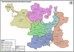
[2] This circle (5) comes under L. B. Nagar (East Zone) of Greater Hyderabad Municipal Corporation. [3] There are five wards in this circle namely Saroornagar (19), Rama Krishna Puram (20), Kothapet (21), Chaitanyapuri (22) and Gaddiannaram (23).

Contents

GHMC New Zones, Circles Map of 2019. GHMC NEW ZONES,CIRCLE MAP.jpg
GHMC New Zones, Circles Map of 2019.

History

The Saroornagar Lake is a reservoir constructed in late 16th century during the Qutb Shahi era to provide water for irrigation of farm lands. This 400-year-old lake is spread across 1 sq. km area. [4]

Asaf Jah II had given away a village beyond Malakpet as inam (gift) to Prime Minister Nawab Arastu Jah Bahadur’s wife Suroor Afza Bai. Arastu built a palace for his wife here and developed a huge garden around it. Since then the village came to be known as Saroornagar. [4]

Saroornagar Palace was built both as a hunting lodge and as a summer resort by Mir Mahbub Ali Khan for himself and his family. The palace came up in 65 acres of land close to the Saroornagar Lake but was considered inauspicious for the Nizam, who then ordered it to be used as an orphanage. On the request of the then British Resident, it was dedicated to the memory of Queen Victoria. It is thus known as Victoria Memorial Home. [4]

Geography

Saroornagar is located at 17°21′22″N78°32′00″E / 17.3561°N 78.5333°E / 17.3561; 78.5333 . [5] It has an average elevation of 487 meters (1601 ft).

Related Research Articles

<span class="mw-page-title-main">Secunderabad</span> Place in Telangana, India

Secunderabad, also spelled as Sikandarabad, is a twin city of Hyderabad and one of the six zones of the Greater Hyderabad Municipal Corporation (GHMC) in the Indian state of Telangana. It is the headquarters of the South Central Railway zone. Named after the Mir Akbar Ali Khan Sikander Jah, Asaf Jah III, Nizam of the Asaf Jahi dynasty, Secunderabad was established in 1806 as a British cantonment. Although both the cities are together referred to as the twin cities, Hyderabad and Secunderabad have different histories and cultures, with Secunderabad having developed directly under British rule until 1948, and Hyderabad as the capital of the Nizams' princely state of Hyderabad.

Kapra is a neighbourhood of Hyderabad city. It falls under Medchal-Malkajgiri district of the Indian state of Telangana and serves as the mandal headquarters of Kapra mandal in Keesara revenue division. It is administered as Circle No. 1 of Greater Hyderabad Municipal Corporation. There are six wards under this circle i.e., Kapra (1), Dr AS Rao Nagar (2), Cherlapally (3), Meerpet HB Colony (4), Mallapur (5) and Nacharam (6).

<span class="mw-page-title-main">Shamshabad</span> Town in Telangana, India

Shamshabad is a city in the Indian state of Telangana. It is located in Shamshabad mandal of Rajendranagar revenue division. Sri Vendikonda Siddalingeshwara Devastanam temple is situated in Siddulagutta Road in Shamshabad mandal. The international airport of Hyderabad is located here.

<span class="mw-page-title-main">Uppal Kalan</span> Suburb in Medchal-Malkajgiri, Telangana, India

Uppal is a suburb in Eastern Hyderabad, Telangana, India. It is the mandal headquarters of Uppal mandal in Keesara revenue division in Medchal-Malkajgiri district. It forms Circle No.2 in the L. B. Nagar Zone of Greater Hyderabad Municipal Corporation. There are four wards i.e., Chilukanagar (7), Habsiguda (8), Ramanthapur (9) and Uppal (10) in this circle.

<span class="mw-page-title-main">Hayathnagar</span> Neighbourhood in Telangana, India

Hayathnagar is a busy residential locality Hyderabad in Ranga Reddy district of the Indian state of Telangana, pincode 500070 & 501505. It is Mandal headquarter of Hayathnagar mandal of Hayathnagar revenue division. Hayathnagar forms circle No 3 in Greater Hyderabad Municipal Corporation. There are four wards i.e Nagole (11) Mansoorabad (12), Hayathnagar (13) and B. N. Reddy Nagar (14) in this circle. It lies on National Highway 65.

Chevella is a town, mandal and suburb of Hyderabad in Ranga Reddy district of the Indian state of Telangana. It is the headquarters of surrounding villages with many government establishments like Judicial court, Revenue Division Office, Acp office under Cyberabad Metropolitan Police. It is also an educational hub with many schools, junior colleges, engineering colleges, business schools etc. There are many hospitals located along with a medical college, the Dr. Patnam Reddy Institute of Medical Sciences. It has become a part of Hyderabad Metropolitan Development Authority.

<span class="mw-page-title-main">Greater Hyderabad Municipal Corporation</span> City governing body in India

The Greater Hyderabad Municipal Corporation (GHMC) is the civic body that oversees Hyderabad, the capital and largest city of the Indian state of Telangana. It is the local government for the city of Hyderabad. It is one of the largest municipal corporations in India with a population of 7.9 million and an area of 650 km².

Shankarpalli is a town in Ranga Reddy district of the Indian state of Telangana. It falls under Shankarpalli mandal of Chevella revenue division.

Moinabad is a village in Ranga Reddy district of the Indian state of Telangana. It falls under Moinabad mandal of Chevella revenue division.

Malakpet is one of the suburbs in the old city area of Hyderabad, Telangana, India. It is famous for TV tower which was built by Teegala Sree Ramulu. This is further divided into two parts, Old Malakpet and New Malakpet and is traditionally considered part of old city. This circle (6) comes under Charminar Zone of Greater Hyderabad Municipal Corporation. There are seven wards in this circle namely Saidabad (24), Moosrambagh (25), Old Malakpet (26), Akberbagh (27), Azampura (28), Chawani (29) and Dabeerpura (30).

<span class="mw-page-title-main">Khairatabad</span> Neighbourhood in Hyderabad District, Telangana, India

Khairatabad is a neigbbourhood in Hyderabad, Telangana, India. It is a mandal in the Secunderabad Revenue division of Hyderabad District. This is a Zone in the Greater Hyderabad Municipal Corporation. There are five circles in this zone namely Mehdipatnam (12), Karwan (13), Goshamahal (14), Khairatabad (17) and Jubilee Hills (18). There are four wards under this Khairatabad circle, they are Khairtabad (91), Somajiguda (97), Ameerpet (98) and Sanathnagar (100).

<span class="mw-page-title-main">Geography of Hyderabad</span> Overview article

Hyderabad is located in central Telangana and is spread over an area of 2,500 km2. The city lies in the Deccan Plateau and rises to an average height of 536 m above the sea level. The city lies at 17.366° N latitude and 78.476° E longitude.

<span class="mw-page-title-main">Habsiguda</span> Neighbourhood in Hyderabad, Telangana, India

Habsiguda is a neighbourhood in Hyderabad, Telangana, India. It is located at the eastern end of the city between Tarnaka and Uppal. It forms Ward No. 7 of Greater Hyderabad Municipal Corporation.

<span class="mw-page-title-main">Hyderabad Metropolitan Development Authority</span>

The Hyderabad Metropolitan Development Authority (HMDA) is the urban planning agency of Hyderabad in the Indian state of Telangana. The HMDA administers the Hyderabad Metropolitan Region, spread over an area of 7,257 km2 (2,802 sq mi) and covers the districts of Hyderabad district, Medchal district, part of Rangareddy district, Bhuvanagiri district, Sangareddy district, Medak district and Siddipet district. HMDA is the largest urban development authority in India. HMDA was formed by the merging of the following erstwhile entities: Hyderabad Urban Development Authority (HUDA), Hyderabad Airport Development Authority (HADA), Cyberabad Development Authority (CDA) and Buddha Poornima Project Authority (BPPA). HMDA was set up for the purposes of planning, co-ordination, supervising, promoting and securing the planned development of the Hyderabad Metropolitan Region. It coordinates the development activities of the municipal corporations, municipalities and other local authorities, the Hyderabad Metropolitan Water Supply & Sewerage Board, the Telangana State Transmission Corporation, the Telangana State Infrastructure Corporation.

Kondapur is a suburb in western part of Hyderabad, Telangana, India. It falls under Serilingampally mandal of Ranga Reddy district. The locality has emerged as a prominent commercial and residential hub, owing to its close proximity to IT corridor of Hyderabad. It is administered as Ward No. 104 of Greater Hyderabad Municipal Corporation.

Badangpet is a satellite city of Hyderabad located in Rangareddy district of Telangana, India. It is one of the 13 Municipal Corporations in Telangana. This is a newly constituted as Municipal Corporation from Nagar Panchayat which was formed on 26-03-2013. It is formed duly merging (8) erstwhile villages i.e. 1. Badangpet 2. Almasguda 3. Nadergul 4. Kurmalguda 5. Gurramguda 6. Balapur (part) 7. Venkatapur and 8. Mamidipally. The area of the ULB is 74.56 Sq. km. Population as per as per 2011 Census is 64579 and presently it is estimated to 100000 population.

<span class="mw-page-title-main">Boduppal</span> City in Telangana, India

Boduppal is a satellite city of Hyderabad and a municipal corporation in Medchal–Malkajgiri District of Telangana, India. It is administered by Boduppal Municipal Corporation. Located at the eastern end of Hyderabad City, it is spread between Nacharam-Mallapur Road and Warangal Highway NH 163. Due to its proximity to Secunderabad and Eastern IT/SEZ of Pocharam, it is emerging as a major residential location in Hyderabad.

<span class="mw-page-title-main">Victoria Memorial Home</span> Orphanage in Telangana, India

Victoria Memorial Home or Yateem Khana-e-Victoria, officially known as Victorial Memorial Home Residential High School is a historic school and orphanage located in Saroornagar in Hyderabad in the Indian state of Telangana.

The localities and neighborhoods of Hyderabad have unique oral histories, dating to the time of the Qutb Shahi dynasty, over 400 years ago, and are named after various people and things. Some are named after a major building or structure in the locality, others named for individuals. The names are mostly in Telugu and Urdu, the major languages of the city. This is a list of localities, neighborhoods and streets of Hyderabad and their etymology.

<span class="mw-page-title-main">Hyderabad Metropolitan Region</span> Metropolitan Area in Telangana

Hyderabad Metropolitan Region is the metropolitan area covered by the city of Hyderabad in the Indian state of Telangana. The entire region is spread over the districts of Hyderabad District, Bhuvanagiri, Medchal-Malkajgiri, Ranga Reddy, Sangareddy, Medak, and Siddipet. Under the jurisdiction of Hyderabad Metropolitan Development Authority, it covers an area of 7,257 km2 (2,802 sq mi) and has a population of 10.7 million people.

References

  1. "Delimitation of Election Wards" (PDF). Greater Hyderabad Municipal Corporation. Archived from the original (PDF) on 10 November 2011. Retrieved 12 June 2017.
  2. "Rangareddy district" (PDF). New Districts Formation Portal. Government of Telangana. Archived from the original (PDF) on 13 October 2016. Retrieved 26 March 2017.
  3. "New circles and wards in GHMC". Greater Hyderabad Municipal Corporation (JPG). Archived from the original on 18 August 2018. Retrieved 13 June 2023.
  4. 1 2 3 "Saroornagar a garden, now Hyderabad gateway". The Hans India. Retrieved 30 July 2018.
  5. Falling Rain Genomics.Sururnagar