Kukatpally

Last updated

Kukatpally
Malysian township at Kukatpally.jpg
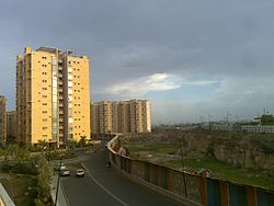
Raintree Park (Malaysian Township)
India Telangana location map.svg
Red pog.svg
Kukatpally
Location in Telangana, India
India location map.svg
Red pog.svg
Kukatpally
Kukatpally (India)
Coordinates: 17°29′N78°25′E / 17.483°N 78.417°E / 17.483; 78.417
Country Flag of India.svg  India
State Telangana
District Medchal-Malkajgiri
City Hyderabad
Government
  Type Mayor-Council
  Body GHMC
Area
  Total20.68 km2 (7.98 sq mi)
Population
 (2020)
  Total252,830
  Density12,225/km2 (31,660/sq mi)
Languages
  Official Telugu
Time zone UTC+5:30 (IST)
PIN
500 072,500 085
Vehicle registration TS-07
Lok Sabha constituency Malkajgiri
Vidhan Sabha constituency Kukatpally
Planning agency HMDA
Civic agency GHMC

Kukatpally is a suburb located in north western part of Hyderabad in the Indian state of Telangana. It is the headquarters of Balanagar mandal in Malkajgiri revenue division of Medchal-Malkajgiri district. [1] It was a municipality prior to its merger into the Greater Hyderabad Municipal Corporation, now it is the headquarters of "North Zone of GHMC". [2]

Contents

It has road connectivity and proximity to the Information Technology hub of Hitech city. [3]

Demographics

The language spoken is predominantly Telugu. [4] It is one of the busiest business hubs in Hyderabad famous for its clothing and eateries. It has the largest density of population within Hyderabad with 33,076 persons per km2. [5]

History

Kukatpally used to be an Industrial corridor in the northwestern part of Hyderabad. Its population began to grow after the early 1990s, with many people migrating from Andhra Pradesh and settling in and around Kukatpally. [6]

Economy

The presence of Mumbai national highway and Kukatpally Housing board has led to a large scale boom in retail activity and currently Kukatpally is a commercial hub in the north western part of Hyderabad.

The land prices of Kukatpally are higher when compared to most of Hyderabad. There are some residential high-rise apartments like Emami Swanlake Apartments etc.

The Min Land Cost starts from 50000 per square yard and higher at 250000 per square yard.

Where as the residential flat price range min of 4500 PerSft to max of 8000 PerSft.

Industries

There are many small scale industries based in Kukatpally - Sanathnagar belt. The major industries are located in Prasanth Nagar which comprises both manufacturing, assembling, mechanical works.

Offices

Kukatpally is a hub for SME offices (Nosch Labs, LIC, IELTS).

Colleges

The place is also a hub for prestigious colleges & institutes like Holy Mary College, Tapasya College of Commerce and Management, Hamstech College of Creative Education and Avinash College. It is also home to the All India Institute of Technology.

Professional services

Transport

Bus terminal in Kukatpally Prashantnagar - Kukatpally bus terminal.jpg
Bus terminal in Kukatpally

Kukatpally is well connected by road, rail and air. The nearest airport is Rajiv Gandhi International Airport, Shamshabad. The railway station for this area is Lingampally. It has three Metro Stations at Kukatpally Metro, KPHB Metro, Balanagar Metro (Moosapet) and can also be reached by MMTS near to Hitech city/ Bharathnagar. TSRTC operates the bus in this area it has excellent connectivity with almost all the parts of Hyderabad.TSRTC maintains a depot at Kukatpally Y Junction.

Related Research Articles

<span class="mw-page-title-main">Alwal</span> Neighbourhood in Medchal-Malkajgiri district, Telangana, India

Alwal is in Hyderabad city, and a suburb of Hyderabad. Earlier, Alwal was a part of Malkajgiri Mandal but in 2006, Alwal Municipality was merged into Greater Hyderabad Municipal Corporation. After the district bifurcation in 2017, Alwal Municipality became a new Mandal "Alwal Mandal", in Malkajgiri revenue division, with Alwal as the Mandal Headquarters. It was a part of Ranga Reddy district before the re-organisation of districts in the state. It was a municipality prior to its merger into the Greater Hyderabad Municipal Corporation.

<span class="mw-page-title-main">Malkajgiri</span> Place in Telangana, India

Malkajgiri also known as Mallikarjuna Giri is a suburb of Hyderabad, Telangana, India. It is located in Medchal–Malkajgiri district and also Sub-District in Medchal District is the headquarters of Malkajgiri mandal in Malkajgiri revenue division. Erstwhile Malkajgiri Major Grampanchayat was upgraded to a municipality in 1965 and became a municipal corporation in 1985. It was merged into the Greater Hyderabad Municipal Corporation in 2007. It was a part of Ranga Reddy district before the re-organisation of districts in 2016.

Quthbullapur is a Village in Hyderabad in the Medchal-Malkajgiri district of the Indian state of Telangana. It is the mandal headquarters of Quthbullapur mandal in Malkajgiri revenue division. The mandal was a part of Ranga Reddy district before the re-organisation of districts in the state. It was a municipality prior to its merger into the Greater Hyderabad Municipal Corporation.

<span class="mw-page-title-main">Transport in Hyderabad</span> Transport network serving Hyderabad and surrounding regions

Hyderabad, the capital and largest city of Telangana, features a growing transportation infrastructure that includes a network of roads, railways, and a developing rapid transit system. These transportation systems play a crucial role in connecting the city's residents and facilitating efficient travel within Hyderabad and its surrounding areas. Furthermore, Hyderabad serves as a significant center for transportation and logistics, playing a crucial role in facilitating the seamless movement of goods and services within the state.

<span class="mw-page-title-main">Uppal Kalan</span> Suburb in Medchal-Malkajgiri, Telangana, India

Uppal is a suburb in Eastern Hyderabad, Telangana, India. It is the mandal headquarters of Uppal mandal in Keesara revenue division in Medchal-Malkajgiri district. It forms Circle No.2 in the L. B. Nagar Zone of Greater Hyderabad Municipal Corporation. There are four wards i.e., Chilukanagar (7), Habsiguda (8), Ramanthapur (9) and Uppal (10) in this circle.

Anandbagh is a locality and a ward in Malkajgiri suburb of Hyderabad city. It falls under the Malkajgiri mandal of the Medchal-Malkajgiri district of the Indian State of Telangana. It is administered as Ward No. 139 of the Greater Hyderabad Municipal Corporation.

Bowrampet also Borampet is a village in Medchal district, Telangana, India. It is a part of Dundigal Municipality. The village is fast developing into a major residential and commercial suburb because of the construction of the Outer Ring Road, proximity to the IT corridor of Hyderabad and pollution-free environs. In the past few years realty prices have gone up drastically and is becoming a destination to the cream of the employees from the IT and Education sectors.

<span class="mw-page-title-main">Bachupally</span> Neighbourhood & Mandal in Medchal-Malkajgiri, Telangana, India

Bachupally is a suburb in the Medchal-Malkajgiri district of the Indian state of Telangana. It is the mandal headquarters of Bachupally mandal in Malkajgiri revenue division. It was a part of Ranga Reddy district before the re-organisation of districts in the state. The postal code (PIN) is 500118.

Mallampet is a village situated at Quthbullapur Mandal, Medchal district, Telangana, India. It is 2 km from Bachupally, 6 km from Nizampet junction, 10 km away from Kukatpally.

<span class="mw-page-title-main">Miyapur</span> Neighbourhood in Ranga Reddy, Telangana, India

Miyapur, located 22.5 kilometres (14.0 mi) northwest of Hyderabad, is part of Greater Hyderabad and administered by GHMC and developed by HMDA. Transportation is managed by UMTA.

<span class="mw-page-title-main">Nizampet</span> Suburb in Medchal-Malkajgiri, Telangana, India

Nizampet is a satellite city of Hyderabad and a municipal corporation situated in Bachupally mandal, Medchal-Malkajgiri district of Telangana, India. It is administered as Nizampet Municipal Corporation.

Allwyn Colony is a residential colony in Hyderabad, Telangana, India. It is located on the northwest fringe of Hyderabad city and is near to Kukatpally. Allwyn Colony is divided into two phases called 1st and 2nd phases. The colony was constructed in 1980s by Hyderabad Allwyn for its employees.

Kondapur is a suburb in western part of Hyderabad, Telangana, India. It falls under Serilingampally mandal of Ranga Reddy district. The locality has emerged as a prominent commercial and residential hub, owing to its close proximity to IT corridor of Hyderabad. It is administered as Ward No. 104 of Greater Hyderabad Municipal Corporation.

Dammaiguda formally known as Dammaigudem which earlier it was Hamlet Village in Nagaram Revenue Village then later burificated as a Separate Gram Panchayat. outer suburb of Hyderabad in Medchal-Malkajgiri district in Telangana, India. It falls under Keesara mandal. It is a residential neighbourhood with a lot of independent houses and upcoming real-estate projects.. It comes under Jawaharnagar police station which is just 2 km from Dammaiguda Rajiv crossroad. it is one of the fastest developing areas in Hyderabad.It's pincode is 500083.Many Middle Class People live here and is near to the ORR Exit 08 and 09 and is 10-15 min from ECIL(Electronics Corporation Of India Limited) based on traffic.

<span class="mw-page-title-main">Boduppal</span> City in Telangana, India

Boduppal is a satellite city of Hyderabad and a municipal corporation in Medchal–Malkajgiri District of Telangana, India. It is administered by Boduppal Municipal Corporation. Located at the eastern end of Hyderabad City, it is spread between Nacharam-Mallapur Road and Warangal Highway NH 163. Due to its proximity to Secunderabad and Eastern IT/SEZ of Pocharam, it is emerging as a major residential location in Hyderabad.

<span class="mw-page-title-main">Silpa Avenue Colony</span> Place in Telangana, India

Silpa Avenue Colony (Hyderabad) is one of residential location near Hydernagar. It is located 20.9 kilometres (12.9 mi) northwest of Hyderabad, is part of GHMC and 100% HUDA approved colony with 226 plots and six parks. Transportation is managed by UMTA.

Balanagar mandal is one of the 15 mandals in Medchal-Malkajgiri district in the Indian state of Telangana. It is under the administration of Malkajgiri revenue division with its headquarters at Balanagar. The mandal is bounded by Quthbullapur, Serilingampally mandals and Hyderabad district.

<span class="mw-page-title-main">Medchal-Malkajgiri district</span> District of Telangana in India

Medchal−Malkajgiri district is a district in the Indian state of Telangana. Shamirpet is the headquarter of the district. It is the second most populous district with a population of 25 lakh and also 91.40% urbanized district in the state of Telangana, standing next only to Hyderabad district which has a population of 40 lakhs. The district shares boundaries with Hyderabad, Medak, Sangareddy, Y. Bhuvanagiri, Siddipet and Rangareddy districts.The most part of the district consist of Hyderabad City (GHMC)

Ramakrishnapuram is a locality in Neredmet.

References

  1. "Medchal−Malkajgiri district" (PDF). New Districts Formation Portal. Government of Telangana. Archived from the original (PDF) on 30 November 2016. Retrieved 23 March 2017.
  2. "Greater Hyderabad Municipal Corporation". www.ghmc.gov.in. Archived from the original on 1 January 2016. Retrieved 2 November 2016.
  3. Nemmani Sreedhar. "Kukatpally sits high on the rental graph". The Hindu.
  4. "Kukatpally, Hyderabad, Telangana Government".
  5. "Kukatpally population density to double by 2041". THE HANS INDIA. 18 June 2018.
  6. "Kukatpally pincode for Area". fastestpincode.com/.