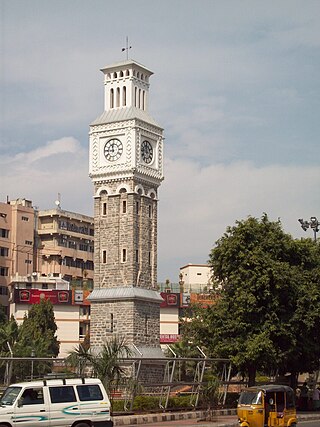
Secunderabad is a twin city of Hyderabad and one of the six zones of the Greater Hyderabad Municipal Corporation (GHMC) in the Indian state of Telangana. It is the headquarters of the South Central Railway zone. Named after the Mir Akbar Ali Khan Sikander Jah, Asaf Jah III, Nizam of the Asaf Jahi dynasty, Secunderabad was established in 1806 as a British cantonment. Although both the cities are together referred to as the twin cities, Hyderabad and Secunderabad have different histories and cultures, with Secunderabad having developed directly under British rule until 1948, and Hyderabad as the capital of the Nizams' princely state of Hyderabad. Since 1956, the city has housed the Rashtrapati Nilayam, the winter office of the president of India. It is also the headquarter of the 54th Infantry Division of the Indian Army. There are also many apartments and residential areas, particularly in the small neighbourhood of Yapral.

Bowenpally is a locality in Secunderabad in the City of Hyderabad, India. It is predominantly an upper middle class area. It has some of the best residential colonies. It is located on the northwest fringe of secunderabad city. Bowenpally is part of the secunderabad area, where the British held sway for several years. The old village of Bowenpally with its people-friendly streets still exist. One among the few old structures left is an old shrine with some rough sculptures of a bull with distinct Kakatiyan design, near the Bowenpally Police Station. It is a juncture connecting different parts of the city.
Tirumalagiri, previously spelt Trimulgherry, is a locality and a Mandal in the city of Secunderabad which falls under Secunderabad Revenue Division, and is a major suburb of Secunderabad, India. The name is an anglicization of Tirumalagiri. It is in the north of Hyderabad District. Trimulgherry used to be base for Britishers in colonial era and many britisher lived here even after the independence. Mainly many churches were built around this area for the British. Few notable ones are Holy Family Church, Wesley Garrison Church, All saints Churches. Theses churches are of old era. A milatary Hospital was built for the britishers, it now serves the indian armed forces now. Trimulgherry also has very famous Surya Bhagwan Temple, one of the few dedicated to Sun God where there is a small pond.

Safilguda originally named as Safilgudem before (1970's) is a residential locality in Neredmet neighbourhood of Hyderabad city. It falls under Malkajgiri mandal in Medchal-Malkajgiri district of Indian state of Telangana. It formed Ward No. 137 of Greater Hyderabad Municipal Corporation in 2009.
Nacharam is a neighbourhood of Hyderabad in the Indian state of Telangana. It falls under Uppal Mandal. It forms Ward No. 6 of Greater Hyderabad Municipal Corporation.
Anandbagh is a locality and a ward in Malkajgiri suburb of Hyderabad city. It falls under the Malkajgiri mandal of the Medchal-Malkajgiri district of the Indian State of Telangana. It is administered as Ward No. 139 of the Greater Hyderabad Municipal Corporation.

Greater Hyderabad Municipal Corporation (GHMC) is the civic body that oversees Hyderabad, the capital and largest city of the Indian state of Telangana. It is the local government for the city of Hyderabad. It is one of the largest municipal corporations in India with a population of 7.9 million and an area of 650 km2.
Balanagar is a neighbourhood of Hyderabad. It is located in Medchal-Malkajgiri district of the Indian state of Telangana. It is under the administration of Balanagar mandal of Malkajgiri revenue division. It was a part of Ranga Reddy district before the re-organisation of districts in the state. It is administered as Ward No. 120 of the Greater Hyderabad Municipal Corporation.
Bowrampet also Borampet is a village in Medchal district, Telangana, India. It is a part of Dundigal Municipality. The village is fast developing into a major residential and commercial suburb because of the construction of the Outer Ring Road, proximity to the IT corridor of Hyderabad and pollution-free environs. In the past few years realty prices have gone up drastically and is becoming a destination to the cream of the employees from the IT and Education sectors.

Khairatabad is a neigbbourhood in Hyderabad, Telangana, India. It is a mandal in the Secunderabad Revenue division of Hyderabad District. This is a Zone in the Greater Hyderabad Municipal Corporation. There are five circles in this zone namely Mehdipatnam (12), Karwan (13), Goshamahal (14), Khairatabad (17) and Jubilee Hills (18). There are four wards under this Khairatabad circle, they are Khairtabad (91), Somajiguda (97), Ameerpet (98) and Sanathnagar (100).

Hyderabad is located in central Telangana and is spread over an area of 2,500 km2. The city lies in the Deccan Plateau and rises to an average height of 536 m above the sea level. The city lies at 17.366° N latitude and 78.476° E longitude.

Habsiguda is a neighbourhood in Hyderabad, Telangana, India. It is located at the eastern end of the city between Tarnaka and Uppal. It forms Ward No. 7 of Greater Hyderabad Municipal Corporation.
Allwyn Colony is a residential colony in Hyderabad, Telangana, India. It is located on the northwest fringe of Hyderabad city and is near to Kukatpally. Allwyn Colony is divided into two phases called 1st and 2nd phases. The colony was constructed in 1980s by Hyderabad Allwyn for its employees.
Kondapur is a suburb in western part of Hyderabad, Telangana, India. It falls under Serilingampally mandal of Ranga Reddy district. The locality has emerged as a prominent commercial and residential hub, owing to its close proximity to IT corridor of Hyderabad. It is administered as Ward No. 104 of Greater Hyderabad Municipal Corporation.

Boduppal is a satellite city of Hyderabad and a municipal corporation in Medchal–Malkajgiri District of Telangana, India. It is administered by Boduppal Municipal Corporation. Located at the eastern end of Hyderabad City, it is spread between Nacharam-Mallapur Road and Warangal Highway NH 163. Due to its proximity to Secunderabad and Eastern IT/SEZ of Pocharam, it is emerging as a major residential location in Hyderabad.

NAD Kotha Road, or NAD X Road, is one of the major junctions and commercial centers in Visakhapatnam, India. It is named for the Naval Armament Depot. The Naval Armament Depot and (NSTL) Naval Science and Technological Laboratories is located here.
Vinayak Nagar is a locality and a ward in Neredmet neighbourhood of Hyderabad city. It falls under Malkajgiri mandal of Medchal-Malkajgiri district of Indian State of Telangana. It is administered as Ward No. 137 of Greater Hyderabad Municipal Corporation.
Gautham Nagar is a locality and a ward in Malkajgiri suburb of Hyderabad city. It falls under Malkajgiri mandal of Medchal-Malkajgiri district of Indian State of Telangana. It is administered as Ward No. 141 of Greater Hyderabad Municipal Corporation.
Ramakrishnapuram is a locality in Neredmet in Medchal-Malkajgiri district of Indian State of Telangana. It falls under Malkajgiri mandal. In the past 15 years, this suburb has become an important residential area in the twin cities. Many colonies, townships and apartments came up in this suburb.

