
Mangalore, officially known as Mangaluru, is a major industrial port city in the Indian state of Karnataka and on the west coast of India. It is located between the Laccadive Sea and the Western Ghats about 352 km (219 mi) west of Bangalore, the state capital, 14 km north of Karnataka–Kerala border and 297 km south of Goa. Mangalore is the state's only city to have all four modes of transport—air, road, rail and sea. The population of the urban agglomeration was 619,664 according to the 2011 national census of India. It is known for being one of the locations of the Indian strategic petroleum reserves.
Dakshina Kannada district is located in the state of Karnataka in India, with its headquarters in the coastal city of Mangalore. It is part of the larger Tulu Nadu region. The district covers an area nestled in between the Western Ghats to its east and the Arabian Sea to its west. Dakshina Kannada receives abundant rainfall during the Indian monsoon. It is bordered by Udupi district to the north, Chikmagalur district to the northeast, Hassan district to the east, Kodagu to the southeast and Kasaragod district of Kerala to the south. According to the 2011 census of India, Dakshina Kannada district had a population of 2,083,625. It is the only district in Karnataka state to have all modes of transport like road, rail, water and air due to the presence of a major hub, Mangalore. This financial district is also known as the Cradle of Indian banking.
The Tunga River is a river in Karnataka state, southern India. The river is born in the Western Ghats on a hill known as Varaha Parvata at a place called Gangamoola. From here, the river flows through two districts in Karnataka - Chikmagalur District and Shimoga District. It is 147 km long and merges with the Bhadra River at Koodli, a small town near Shimoga City, Karnataka. The river is given the compound name Tungabhadra from this point on. The Tungabhadra flows eastwards and merges with the Krishna River in Andhra Pradesh.

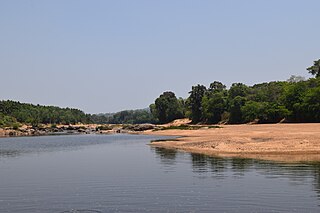
The Netravati River or Netravathi Nadi has its origins at Bangrabalige valley, Yelaneeru Ghat in Kudremukh in Chikkamagaluru district of Karnataka, India. This river flows through the famous pilgrimage place Dharmasthala and is considered one of the holy rivers of India. It merges with the Kumaradhara River at Uppinangadi before flowing to the Arabian Sea, south of Mangalore city. This river is the main source of water to Bantwal and Mangalore.
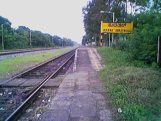
Surathkal is one of the major localities in the northern part of Mangalore city located on National highway 66 in the Dakshina Kannada district, Karnataka state, India on the shore of Arabian sea. It is a municipality merged with Mangalore City Corporation. It lies between Gurupura (Phalguni) and Pavanje (Nandini) rivers. It is the northern suburb and can be considered as the northernmost area of Mangalore City until Mukka. Surathkal has a railway station on Konkan railway route which connects cities of Mumbai to Mangaluru. Surathkal is 8 km north of New Mangalore seaport, 4 km west of Mangalore Refinery and Petrochemicals Limited and 16 km west of Mangalore International Airport This region has developed educationally, industrially and commercially can be regarded as one of the crucial localities in Mangaluru and coastal Karnataka. The only NIT of Karnataka is situated here which is adjacent to the national highway NH 66. Mukka a popular name in Indian surfing is also situated close to Surathkal. Surathkal beach is well known for its cleanliness and well maintained like other beaches in Mangalore.

Tannirbhavi beach is a beach in Mangalore, Karnataka, India. It is one of the most popular tourist destinations in coastal Karnataka. Along with the beach, Sultan Battery, Tannirbavi Tree Park & the proposed Marine museum are also the tourist attractions. It can be reached either by land near Kuloor Bridge or by ferry via Gurupura river from Sultan Battery.

Kumta is a town and taluk in the Uttara Kannada district of Karnataka, India. It is one of the important stations along the Konkan Railway line running between Mumbai and Mangalore.

Sakleshpur, also known as Sakleshpura or Sakleshapura, is a hill station town and headquarters of Sakleshpur taluk and one of the two Sub-divisional headquarters in Hassan district in the Indian state of Karnataka.

Adyar is a suburb of Mangalore city in Karnataka, India.

Kasaragod is one of the 14 districts in the southern Indian state of Kerala. Its northern border Thalappady is located just 9 km south to Ullal, which is the southernmost portion of the major port city Mangalore, on the southwestern Malabar coast of India.

The 16345 / 16346 Netravati Express is a daily Express train connecting capital cities of Kerala and Maharashtra. It operates between Thiruvananthapuram Central and Lokmanya Tilak Terminus. The train runs on the Konkan Railway.
Harekala is a village in the southern state of Karnataka, India. It is located in the Mangalore taluk of Dakshina Kannada district.
Monte Mariano Church at Farangipet in Mangalore, India, is a church where the Roman Catholic festival Monti Fest was initiated by Joachim Miranda, a Goan Catholic priest at Farangipet in 1763.
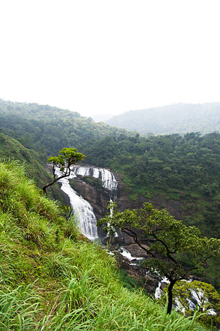
Mallalli Falls is situated in the Sakleshpur Taluk of Hassan District in Karnataka state in south India. The Kumaradhara River is the main watercourse for this waterfall. The Kumaradhara later flows through Kukke Subrahmanya and merges with the Netravati River at Uppinangadi, which then empties into the Arabian Sea at Mangalore.
Palakkad railway division is one of the six administrative divisions of the Southern Railway zone of Indian Railways. It is headquartered at city of Palakkad, Kerala. It is the smallest railway division in Southern Railway. It was formed by dissolving the Podanur division. Managing 588 route kilometers of track in the states of Kerala, Tamil Nadu, Karnataka and Mahé, it is one of the oldest railway divisions in India and had a route connectivity of nearly 1,247 km before the formation of current Thiruvananthapuram and Salem divisions. The terminal facility of Palakkad division is situated in Shoranur Junction & Mangalore Central of Karnataka state.
Kulur or Kuloor is a locality in Mangalore city, Karnataka, India about 7 kilometres (4.3 mi) north of the city centre. Kulur is one of the major commercial junctions in the city.
Odadadka is a beautiful place situated near the banks of the Netravati River, in Sarapady village, Bantwal taluk, Dakshina Kannada district, Karnataka state, India. It is well connected to taluk headquarter Bantwal through Poopadikatee by road.
Netravati Bridge is on NH 66 in Mangalore, Dakshina Kannada, Karnataka, India, built over Netravati River, which connects Mangalore city with its southern suburbs Thokottu, Ullal and Deralakatte. This bridge is also called Ullal Bridge as this bridge is located in the town called Ullal in Mangalore taluk.

Surathkal railway station is one of the main railway stations of Mangalore city along with Mangalore Central railway station and Mangalore Junction railway station and is located in north Mangaluru on Konkan Railway route. Twenty-two trains stop here.KRCL operates RO-RO services from Suratkal to Verna, Kolad, and Karembeli. As per the Konkan railway map, Surathkal railway station is at a distance of 733.825 kilometers from the northern starting point of the Konkan railway line at Roha and 4.615 kilometers from Thokur which is the southern endpoint of Konkan railway jurisdiction. The Surathkal railway station is at distance of 26.285 Kilometre from Mangaluru Central(MAQ) railway station.
