Aurangabad district, officially known as Chhatrapati Sambhajinagar district, is one of the 36 districts of the state of Maharashtra in western India. It borders the districts of Nashik to the west, Jalgaon to the north, Jalna to the east, and Ahmednagar to the south. The city of Aurangabad houses the district's administrative headquarters. The district has an area of 10,100 km2, of which 37.55% is urban and the rest is rural. Aurangabad District is a major tourism region in Marathwada, with attractions including the Ajanta Caves and Ellora Caves.

Nashik district,(Marathi: [n̪ɑɕɪk]) formerly known as Nasik district, is a district in Maharashtra, India. The city of Nashik is the administrative headquarters of the district. Nashik is well known for the production of wine. Nashik is also known as Mini Maharashtra, because the climate and soil conditions of Surgana, Peth, Igatpuri resembles with Konkan. Niphad, Sinnar, Dindori, Baglan blocks are like Western Maharashtra and Yeola, Nandgaon, Chandwad blocks are like Vidarbha Region. Nashik is the biggest city in the district while Malegaon is the second biggest city. Manmad, Igatpuri, and Sinnar are some of the big cities situated in the Nashik District. Manmad is one of the biggest railway junctions in India while the city of Malegaon is famous for its powerloom.
Vaijapur is a city and a municipal council in Aurangabad district in the Indian state of Maharashtra. It is bordered by the Nashik districts to the west, Kannad tehsil to the north, Gangapur tehsil to the east, and Ahilyanagar districts to the south. Vaijapur is the headquarters of Vaijapur tehsil and also known as the Gateway of Marathwada.

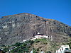
Saptashrungi or Saptashringi is a site of Hindu pilgrimage situated 60 kilometres (37 mi) from Nashik in Indian state of Maharashtra. According to Hindu traditions, the goddess Saptashrungi Nivasini dwells within the seven mountain peaks. It is located in Nanduri, Kalwan taluka, a small village near Nashik in India. The Marathas and some Hindu tribes have worshipped the goddess from a long time and some worship her as their kuldaivat. There are 510 steps to climb the gad. To go from below to the temple, the temple trust has also provided the facility of a furnacular trolley. Its work started in July 2018. There are a total of 6 coaches in this trolley, and 10 passengers can sit in one coach. This trolley takes 3 minutes to reach the temple. Passengers have to climb 20 to 25 stairs to go from the station above the trolley to the temple. This trolley carries about 5000 passengers every day. Devotees visit this place in large numbers every day. The temple is also known popularly as one of the "three and half Shakta pithas" of Maharashtra. The temple is also one among the 51 Shakta pithas located on the Indian subcontinent and is a location where one of Sati's limbs, her right arm is reported to have fallen. Its half shaktipeeth among three and half shaktipeeth of Maharashtra.
Kalwan is a tehsil in Kalwan subdivision of Nashik District in Maharashtra, India. Kalwan is situated 80 km from Nashik and 251 km from state capital Mumbai. Saptashrungi Gad, a religious shrine of Goddess Saptashrungi, is situated in Kalwan taluka. Saptashrungi Gad is located 22 km from Kalwan city. Dhodap hill fort, which is a popular mountain climbing destination and 3rd highest peak in Maharashtra, is situated 8 km from Kalwan city. Abhona is the largest town in Kalwan tehsil after Kalwan city. Kalwan is situated in the delta of Behadi and Girana river. Black soil and ample water are available for cultivation of cash crops. This significantly contributes to the GDP of Kalwan tehsil.

Chandwad (IPA:Cāndavaḍa) is a town located in the Nashik district in Maharashtra. It is 250 km from Mumbai. The 11th-century Jain Caves, Renuka devi mandir, Chandreshwar temple and Rangmahal are in Chandwad.
State Highway 10, commonly referred to as MH SH 10, is a normal state highway that runs south through Pune, Ahmednagar, Nashik and Dhule districts in the state of Maharashtra, India. This state highway touches the cities of Dondaicha, Shevade, Mehergaon, Kusumbe, Malegaon, Manmad, Yeola, Kopargaon, Shirdi Rahata, Rahuri, Ahmednagar, Kashti, and Daund.
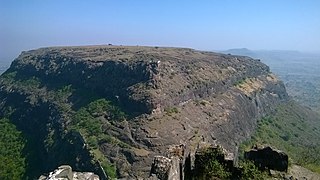
Dhodap is one of the hill forts in Maharashtra state in India. Situated in Kalwan taluka in the Nashik district. the fort is 4829 ft above sea level. It is the site of the second-highest fort in the Sahyadri mountains after Salher. Dhodap hill is the third-highest peak in Maharashtra after Kalsubai and Salher and the 29th highest peak in Western Ghats.

Abhona is a village in Kalwan tehsil of Nashik district in the Indian state of Maharashtra. It belongs to the North Maharashtra region.
Selbari is a mountain range located in Nashik District in Maharashtra, India. Spanning east-west the hills form the northernmost extent of the Sahyadris and serve as a natural boundary between Nashik District and Dhule district. The range is gifted with a number of peaks including the only two-pinnacled peak of Mangi-Tungi rising to a considerable height of up to 1,331 meters.
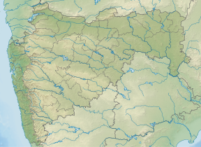
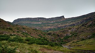
Nashik District, a district in Maharashtra, India, is noted for the mountains and hills occupying the north and north-east of its territory. These hill ranges are eastward spurs of the Western Ghats and form prominent landmarks in the district, some noted for the shrines they harbor while others for the trekking adventures which can be undertaken while ascending the peaks. Broadly categorized, the hills can be segregated into 3 noteworthy ranges:
Kadva river is a minor but important tributary of Godavari in Nashik district, Maharashtra, India. It originates and flows through the Dindori Taluka of Nashik District.

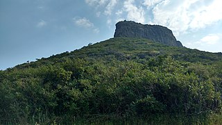
Ankai Fort is a historic site found in the Satmala Range hills in western India. It is located in Yeola Taluka of Nashik district in the state of Maharashtra. The fort was built by Yadava of Devgiri. Geographically, it is near Manmad. The Ankai fort and Tankai fort are two different forts on adjacent hills. A common fortification is constructed to secure both. The Ankai fort is located on a hill with perpendicular scarps on all the sides, except for a narrow nose on the eastern side.
Tankai fort is a hill, part of the Satmala Range, with the ruins of a large Maratha hill fort on the peak. With Ankai Fort near this fort are known as Ankai-Tankai, the strongest hill fort in the Nashik district, rises about 900 feet above the plain and 3200 feet above the sea. It is located from Manmad in Yeola taluka of Nashik district in Maharashtra, India.
Indrai Fort / Indragiri Fort is a fort located 75 km from Nashik, in Nashik district, of Maharashtra. This fort though is an important fort in Nashik district but, it is less visited by the trekkers. In Chandwad taluka, there are 4 forts in a line on the Satmal hill range, the Chandwad fort, Indrai fort, Rajdher fort, and Koldher fort. This fort is easy to climb but requires 3 hours to reach the fort.
Three and a half Shakti Peethas are reported in Maharashtra.
Rajdeher Fort (Marathi: राजधेर किल्ला) is a fort located 10 km (6.2 mi) from chandwad, Nashik district, of Maharashtra. This fort is an important fort in Nashik district.
Ahivant Fort is a fort located 55km from Nashik, in Nashik district, of Maharashtra. This fort is an important fort in Nashik district. The three forts Achala, Ahivant, and Mohandar are very close by. The other two forts were constructed to guard the Ahivant fort.
Achala Fort is a westernmost fort in the Satmala hill range. It is located 55 km from Nashik, in Nashik district, of Maharashtra. This fort is adjoining the Ahivant Fort. The three forts Achala, Ahivant, and Mohandar are very close by. The Achala and Mohandar forts were constructed to guard the Ahivant fort. Captain Briggs has described it as a large hill, whose ascent is very easy till it reaches the top where it is very steep.

Mohandar Fort / Shidaka fort is a fort located 55 km from Nashik, in Nashik district, of Maharashtra, India. This fort is an important fort in Nashik district. The three forts Achala, Ahivant, and Mohandar are very close by. This fort was constructed to guard the Ahivant fort. This fort can be seen from a long distance due to the presence of needle hole in the cliff below this fort.