
Idukki is one of the 14 districts in the Indian state of Kerala in the southwest of the country. It is the largest district in Kerala and lies amid the Cardamom Hills of Western Ghats in Kerala. Idukki district contains two municipal towns – Kattappana and Thodupuzha, and five taluks.
The Cardamom Hills or Yela Mala are mountain range of southern India and part of the southern Western Ghats located in Idukki district, Kerala, India. Their name comes from the cardamom spice grown in much of the hills' cool elevation, which also supports pepper and coffee. The Western Ghats and Periyar Sub-Cluster including the Cardamom Hills are UNESCO World Heritage Sites.

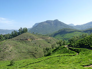
Devikulam is a Grama Panchayat and small hill station about 8 kilometres (5.0 mi) away from Munnar in the Idukki District of Kerala, India. It lies about 1,800 metres (5,900 ft) above sea level.
The Muthuvans or Mudugars are tribe of cultivators in hills of Coimbatore and Madurai, India. They are also found in Adimali and Devikulam forest regions of Idukki district, Kerala. They people were loyal subjects of the dynasty of Madurai, according to tribal legend. When the dynasty was deposed, the surviving royal members migrated to Travancore, central Kerala. On their way to Kerala, they carried the idols of Madurai Meenakshi, the deity of the royal family, on their backs. The word Muthuvar in Tamil is used to denote the same community in Tamil Nadu. The word "Muthu" means elder and literal meaning of "Muthuvar" is elders. Muthuvan are the ancient tribes of this land.

Kurinjimala Sanctuary protects the approximately 32 hectare core habitat of the endangered Neelakurinji plant in the Kottakamboor and Vattavada villages in Devikulam Taluk, in the Idukki district of Kerala, a state in southern India.
Kannan Devan Hills is a large village located in Devikulam Taluk of Idukki District in the Indian state of Kerala. It is situated near the state border of Tamil Nadu about 25 kilometres northeast of the district seat Painavu and 8 kilometres north of the subdistrict seat Devikulam. In 2011, it was home to 55,738 residents.
Mannamkandam is a village in Devikulam Taluk, Idukki District, Kerala, India. It is located near the town of Adimali, approximately 22 kilometres northwest of the district capital Painavu, and 26 kilometres west of the taluk capital Devikulam. In 2011, it had a population of 40,593.
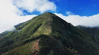
Meesapulimala is an Indian peak, the next south of the second highest peak of the Western Ghats on the border of Idukki district, Kerala state. Its peak is 2,640 metres (8,661 ft) above sea level. The name derives from its appearance from the grass with prominent whiskers. It is located in between the Anaimalai Hills and Palani Hills near Suryanelli around 20 km away from Munnar. The Kolukkumalai tea estate, Top Station and Tipadamala is also nearby.
Joice George is an Indian politician and a Member of Parliament of the 16th Lok Sabha of India.

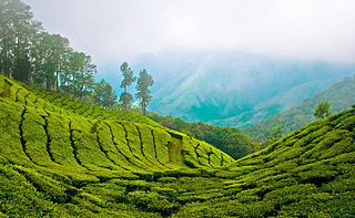
Kolukkumalai is a small village/hamlet in Bodinayakanur Taluk in the Theni district of the Indian state of Tamil Nadu. It is home to the highest tea plantation in the world with the tea grown here possessing a special flavour and freshness because of the high altitude. It is located near Munnar in Idukki district of Kerala.

Kulamavu Dam is a gravity/masonry dam on Kilivillithode, which is a tributary of the Periyar river in Arakkulam village, Idukki district in the Indian state of Kerala. It is one of three dams associated with the Idukki hydroelectric power project in the Indian state of Kerala. This dam is located towards the western side of the Idukki Arch Dam. This is a gravity dam with the top portion in concrete and the bottom in masonry.

Vandaravu is the highest peak in the Palani hills in Tamil Nadu, India.
Eravimala (ഇരവിമല) is the highest peak located in the Anamalai Hills in the Western Ghats, India. It is situated at the Idukki District of Kerala, and stands at 7,880 feet (2,400 m). It is one of the 14 highest peaks in the district which exceed a height of 2,000 metres (6,600 ft) above sea level. The highest one is Anamala (Anamudi) at 8,841 feet (2,695 m). It is the tenth highest peak in South India.

Devikulam State assembly constituency is one of the 140 state legislative assembly constituencies at the state Kerala in southern India. It is also one of the 7 state legislative assembly constituencies included in the Idukki Lok Sabha constituency. Since 2011, the constituency has been reserved for members of Scheduled Caste (SC). After the 2021 assembly elections, A. Raja of CPI(M) was elected as the MLA however he was subsequently disqualified by Kerala High Court on 20 March 2023.
The District Panchayaths are the territory level of local government under Panchayathi Raj act in India. Idukki District Panchayath is in Kerala state in India. It was established in 1995 in accordance with Kerala Panchayath Raj Act 1994. The District Panchayat Samithi is functioning as a local governing body at district level. Its members are elected by people from each electoral division. The Electoral college is based on the universal suffrage. The Idukki District Panchayath has jurisdiction over Idukki District, except for the municipal towns of Kalpatta and Thodupuzha. The State Election Commission is responsible for conducting these elections.
Devikulam taluk is one of the 5 taluks in Idukki district of the Indian state of Kerala. Devikulam taluk comprises 13 villages.

Kallar Dam is a small, diversion dam constructed at Perinjamkutty river in Nedumkandam grama panchayat of Idukki district, Kerala, India. It acts mainly as a diversion dam to supply water to the Idukki dam.
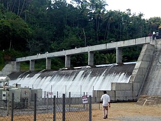
Chenkulam Dam is a gravity dam located on the Muthirapuzha river in Vellathooval panchayat of Idukki district in the Indian state of Kerala. It spans 144.50 metres (474.1 ft) long and stands 26.82 metres (88.0 ft). It hosts a 48 MW power plant.
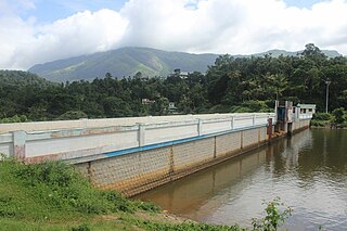
Vellathooval Dam is a diversion dam built on the Muthirappuzha river in Vellathooval village in Devikulam taluk of Idukki district in Kerala, India. The height of the dam from the deepest foundation is 16 metres (52 ft) and length is 75 metres (246 ft). Water from the Sengulam Power House and from the Muthirapuzha river gets released to the Vellathooval dam. Water from this dam is diverted through a canal system to the powerhouse near Panniyar After the water flow is used to generate hydroelectricity, the water is released back into the river. The dam is one of the major tourist attractions in the Idukki District, Kerala.

Viripara Weir is a Diversion weir constructed across Upper Kallar river which is a tributary of Pooyankutty river in Mankulam village of Idukki district in Kerala, India. The water flows from the dam to Menachery river and flows through the taluk of Devikulam. The Viripara weir is constructed as an augmentation scheme to Neriamangalam Hydro Electric Project. Upper Kallar, a tributary of Pooyankutty river is diverted in to Kallarkutty reservoir by a low diversion weir at Viripara along with a short diversion tunnel.

