Selbari Range

Last updated
Selbari Range
India Maharashtra relief map.svg
Red triangle with thick white border.svg
Selbari Range
Highest point
Elevation 1,331 m (4,367 ft)
Coordinates 20°50′29.5″N74°05′32.7″E / 20.841528°N 74.092417°E / 20.841528; 74.092417
Geography
District Nasik
Parent range Western Ghats
Geology
Mountain type Flood basalt
Type of rock Basalt

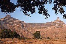
Selbari is a mountain range located in Nashik District in Maharashtra, India. Spanning east-west the hills form the northernmost extent of the Sahyadris and serve as a natural boundary between Nashik District and Dhule district. The range is gifted with a number of peaks including the only two-pinnacled peak of Mangi-Tungi rising to a considerable height of up to 1,331 meters.

Contents

Traditionally, the range is limited to the hills sprawling north [1] of the Mausam River but extended definitions also include those south of the Mosam river which are connected to the former in a semi-circular loop. This shorter southern extension is known as the Dolbhari hills named after a village settlement around their base. To avoid disambiguity, sources refer to this agglomeration as the Selbari-Dholbari [2] range.

Geology

The mountain range was formed by the same historical events that gave birth to the Western Ghats. Resting on the Deccan Plateau geologically identified as a large igneous province, it consists of solidified Flood basalt dating back to the Cenozoic era.

Geography

The peaks progressively lose altitude towards the east, with westernmost peaks being twice as tall as those at the eastern end. East of this hill is situated the Selbari pass facilitating road communication in the depression caused by the headward erosion across this range by the Salvar nala, a tributary of the Panjhra river of Dhule district. Further east are situated the Hindabari pass and Thermal fort. Near the eastern extremity of this range within the district is situated the Galna fort, which has given its name to this line of hills, commanding a pass route from south to north. The western edge falls gently to the Dang region in Gujarat.

List of notable peaks

The Highest list in the Selbari range (excluding Dholbari) is the Mangi-Tungi peak with its higher pinnacle Mangi rising up to 4360 feet. If one includes the Dholbari range then, the tallest peak would be Salher which is also the highest fort and the second highest peak in Maharashtra.

Mangi-Tungi Mangi Tungi twin pinnacle.jpg
Mangi-Tungi
Salher Salher Fort.jpg
Salher
NameElevation in meters
Mangi-Tungi 1,331m
Tambolya1,078m
Nhavi Killa1280
Hanumantgad1062
Der Kharak1099

Additional peaks in the Silbari-Dholbari range:

NameElevation in meters
Salher 1,567m
Takara1,478m
Mulher1,317m
Chauler1,137m
Galna787m

See also

Related Research Articles

<span class="mw-page-title-main">Kalsubai</span> Mountain in India

Kalsubai is a mountain in the Western Ghats, located in the Indian state of Maharashtra. Kalsubai is the highest peak in Maharashtra and is located in Ahmednagar district in Akole Taluka. Its summit, situated at an elevation of 1,646 metres (5,400 ft), is the highest point in Maharashtra and hence it is known as the "Everest of Maharashtra".

<span class="mw-page-title-main">Igatpuri</span> Town in Maharashtra, India

Igatpuri is a town and a Hill Station. It is also a municipal council in Nashik District in the Indian state of Maharashtra. It is located in the Western Ghats. Igatpuri railway station lies in Nashik District, between Mumbai and Nashik Road on the Central Railway. Igatpuri is known for Vipassana International Academy, where ancient techniques of meditation is taught called Vipassana. The place is one of the best places to visit in Maharashtra in monsoon. It is a hill station on busy Mumbai-Agra NH-3 only 45 km from Nashik and 130 km from Mumbai.

<span class="mw-page-title-main">Nashik district</span> District of Maharashtra in India

Nashik district, formerly known as Nasik district, is a district in Maharashtra, India. The city of Nashik is the administrative headquarters of the district. Nashik is well known for the production of wine. Nashik is also known as Mini Maharashtra, because the climate and soil conditions of Surgana, Peth, Igatpuri resembles with Konkan. Niphad, Sinnar, Dindori, Baglan blocks are like Western Maharashtra and Yeola, Nandgaon, Chandwad blocks are like Vidarbha Region. Nashik is the biggest city in the district while Malegaon is the second biggest city. Manmad, Igatpuri, and Sinnar are some of the big cities situated in the Nashik District. Manmad is one of the biggest railway junctions in India while the city of Malegaon is famous for its powerloom.

<span class="mw-page-title-main">Bhandardara</span> Village in Maharashtra, India

Bhandardara is a holiday resort village near Igatpuri, in the western ghats of India. The village is located in the Akole tehsil, Ahmednagar district of the state of Maharashtra, about 185 kilometers (115 mi) from Mumbai, 155 kilometers (96 mi) from Ahmednagar and 73 kilometers (45 mi) from Nashik.

<span class="mw-page-title-main">Mangi-Tungi</span> Twin-pinnacled peak in Maharashtra, India

Mangi-Tungi is a prominent twin-pinnacled peak and Digambar Jain Pilgrimage Site, located near Tahrabad about 125 km from Nashik, Maharashtra, India. Mangi, 4,343 ft (1,324 m) high above sea level, is the western pinnacle and Tungi, 4,366 ft (1,331 m) high, the eastern. Mangi-Tungi is 30 km (19 mi) from the city of Satana.

<span class="mw-page-title-main">Ghat Roads</span> Access routes into the mountainous Western and Eastern Ghats in India

Ghat Roads are access routes into the mountainous Western and Eastern Ghats, mountain ranges of the Indian subcontinent. These roads are remarkable feats of engineering, and most were constructed during the British Raj. Ghat Roads were built to connect to the hill stations established in the mountains for residents to avoid summer heat. They generally served to connect coastal areas with the upper Deccan Plateau.

<span class="mw-page-title-main">Tourism in Maharashtra</span>

Maharashtra attracts tourists from other Indian states and foreign countries. It was the second most visited Indian state by foreigners and fifth most visited state by domestic tourists in the country in 2021. Aurangabad is the tourism capital of Maharashtra.

<span class="mw-page-title-main">Baglan taluka</span> Taluka/Tehsil in Maharashtra, India

Baglan is a taluka (tehsil) in Nashik District in the Indian state of Maharashtra. Sometimes Baglan Taluka is unofficially referred to as Satana, because of that city's dominance within the taluka.Padeshwar is also located in baglan taluka which is an fort

Dhodap is one of the hill forts in Maharashtra state in India. Situated in Chandwad taluka in the Nashik district. the fort is 4829 ft above sea level. It is the site of the second-highest fort in the Sahyadri mountains after Salher. Dhodap hill is the second-highest hill peak in Maharashtra after Kalsubai and Salher and the 29th highest peak in Western Ghats.

<span class="mw-page-title-main">Brahmagiri (Maharashtra)</span> Hill in the Western Ghats

Brahmagiri is a hill in the Western Ghats of Maharashtra. It is situated in Nashik District in the Indian state of Maharashtra. Trimbakeshwar Shiva Temple is located near this place. The origin of the Godavari River, which Hindus consider sacred, is near Trimbak. It flows for 1,465 kilometres (910 mi), first eastwards across the Deccan Plateau then turns southeast, entering the West Godavari district and East Godavari district of Andhra Pradesh, until it splits into two watercourses that widen into a large river delta and flow into the Bay of Bengal.

<span class="mw-page-title-main">Abhona</span> Village in Maharashtra

Abhona is a village in Kalwan tehsil of Nashik district in the Indian state of Maharashtra. It belongs to the North Maharashtra region.

<span class="mw-page-title-main">Satmala Range</span>

Satmala (pronunciation:[sɐtmaːla]) is a mountain range which runs across Nashik District, Maharashtra. They are an integral part of the Sahyadris range within Nashik. These peaks are visible from a greater part of the district and form prominent landmarks. The highest of them is Dhodap. Dhodap hill is the third highest hill peak in Maharashtra after Kalsubai and Salher and 29th highest peak in the Western Ghats. At the eastern side of this range lies the Chandvad range. There is a range with the same name Satmala in Telangana.

Nashik District, a district in Maharashtra, India, is noted for the mountains and hills occupying the north and north-east of its territory. These hill ranges are eastward spurs of the Western Ghats and form prominent landmarks in the district, some noted for the shrines they harbor while others for the trekking adventures which can be undertaken while ascending the peaks. Broadly categorized, the hills can be segregated into 3 noteworthy ranges:

<span class="mw-page-title-main">Trimbakeshwar Range</span> Mountain range in Maharashtra, India

Trimbakeshwar Range is a mountain range in the Western Ghats of Maharashtra entirely situated in Nashik District. The range lies 30 km southwest to the district headquarters Nashik. The saddle shaped depression of the Brahmagiri mountain protects Trimbak, a town considered holy by Hindus Devotees throng to this town to pay visit to the sacred Trimbakeshwar Shiva Temple. The northern face of the range is the birthplace of India's 2nd longest river Godavari.The southern face of these hills are covered with dense forests and thus form a catchment area for the Upper Vaitarna Reservoir, the most important and reliable source of potable water supply to the metropolitan city of Mumbai. Trimbakeshwar range also contain the Anjaneri hills though a minority of authors consider the latter to be a distinct range and often prefer to use the synonym Trimbak-Anjaneri to avoid disambiguation.

Darna is a minor right-bank tributary of Godavari in the Nashik District, Maharashtra, India. Rising north of the Kalsubai range, it drains Igatpuri, Nashik and Niphad Talukas of Nashik District. The conjunction with Godavari is situated at Darnasangvi.

<i>Statue of Ahimsa</i> Jain idol

The Statue of Ahimsa is located at Mangi-Tungi, in Nashik, in the Indian state of Maharashtra. It is the tallest Jain statue in the world. The statue depicts the first Jain Tirthankara, Rishabhanatha. The statue is 108 feet (33 m) tall – 121 feet (37 m) including pedestal. The statue has been carved out of the Mangi-Tungi hills, which are considered to be sacred by the Jains.

<span class="mw-page-title-main">Mora fort</span>

Mora fort is located in the Baglan area of Nashik district. There are two main hill ranges in Baglan area, the Selbari range is south of the Dolbari hill range. These two ranges run parallel to each other in east-west direction. Moragad is located on Selbari hill range. All these forts were maintained to keep watch on the Burhanpur-Surat ancient commercial road. The road passes between the two hill ranges. Mora fort is a small fort, east of Mulher fort.

<span class="mw-page-title-main">Culture of Nashik</span> Overview of the culture of Nasik (India)

The culture of the city of Nashik, in northwestern Maharashtra, is centred around Hindu customs and festivals.

<span class="mw-page-title-main">Hargad Fort</span>

Hargad Fort is located in the Baglan area of Nashik district. There are two main hill ranges in Baglan area, the Selbari range is south of the Dolbari hill range. These two ranges run parallel to each other in east-west direction. Hargad is located on Selbari hill range. All these forts were maintained to keep watch on the Burhanpur-Surat ancient commercial road. The road passes between the two hill ranges. Hargad fort is a small fort, close to Mulher fort. These are key forts situated between fertile lands of Khandesh and port city of Surat.

Bitangad Fort is a fort in Nashik district in the Igatpuri taluka in Maharashtra state of India.

References

  1. "NASIK DISTRICT GAZETTEERs". cultural.maharashtra.gov.in. Archived from the original on 25 September 2013. Retrieved 17 January 2022.
  2. "Mangi-Tungi , Nashik District, Western Ghats, India, Adventure, Trekking". Trekshitiz.com. Retrieved 30 December 2018.