Madikeri

Last updated

Madikeri
Mercara
City
Coorg - The Scotland of India.jpg
Grasslands in Kumara Parvatha, Madikeri during Monsoon season
Nickname: 
Misty City of Karnataka
India Karnataka location map.svg
Red pog.svg
Madikeri
Location in Karnataka, India
India location map.svg
Red pog.svg
Madikeri
Madikeri (India)
Coordinates: 12°25′15″N75°44′23″E / 12.4209°N 75.7397°E / 12.4209; 75.7397
CountryFlag of India.svg  India
State Seal of Karnataka.svg Karnataka
District Kodagu
Region Malenadu
Muddurajana Keri1681
Founded by Mudduraja
Government
  Body City Municipal Council
  CMC CommissionerVijaya
Area
  City17.04 km2 (6.58 sq mi)
  Rural
1,435.32 km2 (554.18 sq mi)
Elevation
_at_the_Fort
1,170 m (3,840 ft)
Population
 (2011) [1]
  City33,381
  Density2,000/km2 (5,100/sq mi)
   Rural
113,202
Languages
  Administrative Kannada
  Regional Arebhashe(Kannada dialect), Kodava, Tulu
Time zone UTC+5:30 (IST)
PIN
571 201
Telephone code08272
Vehicle registration KA-12
Website www.madikericity.mrc.gov.in/en

Madikeri is a hill station town in Madikeri taluk and headquarters of Kodagu district in Karnataka, India. Its original name was Muddurajanakeri which means "the city of Mudduraja".

Contents

It is recognised as one of the world's eight "hottest hotspots" of biological diversity and also one of UNSECO World Heritage Sites. [2]

Etymology

Madikeri was known as Muddu Raja Keri, [3] which meant Mudduraja's town, was named after the prominent Haleri king Mudduraja who ruled Kodagu from 1633 to 1687. [4] [5] From 1834, during the British Raj, it was called Mercara. It was later renamed to Madikeri by the Government of Mysore. [6] [7]

History

Map c. 1854 Madikeri map.jpg
Map c. 1854

The history of Madikeri is related to the history of Kodagu. From the 2nd to the 6th century AD, the northern part of Kodagu was ruled by Kadambas. The southern part of Kodagu was ruled by Gangas from the 4th to the 11th century. After defeating the Gangas in the 11th century, Cholas became the rulers of Kodagu. In the 12th century, the Cholas lost Kodagu to the Hoysalas. Kodagu fell to the Vijayanagar kings in the 14th century. [5]

After their fall, the local chieftains like Karnambahu (Palegars) started ruling their areas directly. They were defeated by Haleri Dynasty founder Veeraraju, (Nephew of Ikkeri Sadashiva Nayaka who were descendants of Talakadu Ganga Dynasty). In the year 1700 AD Ikkeri Somashekara Nayaka gifted Puttur and Amara Sullia Magnes of Tulunadu to Haleri Kings.

Descendants of Veeraraju who are known as "Haleri Dynasty" ruled Kodagu from 1600 to 1834 AD. Haleri king Mudduraja built the Fort in Madikeri and made it [8] as their capital. Mudduraja, the third Haleri king started levelling the land around Madikeri and built a fort in the year 1681. Madikeri Fort which was original built of mud and was replaced by Tipu Sultan. Kodagu became a part of British India after 1834 AD. [9] [10]

Demographics

As of 2011 India census, [11] Madikeri had a population of 33,381. Males constitute 57.2% of the population and females 42.8%. Madikeri had an average literacy rate of 85%, higher than the national average of 69.3: male literacy was 83%, and female literacy 80%. 11% of the population was under 6 years of age.

Geography and climate

Madikeri features a tropical highland climate as it has an elevation of 1,170 m (3,840 ft). Madikeri is located at 12°25′N75°44′E / 12.42°N 75.73°E / 12.42; 75.73 . [12] [13] Madikeri lies in the Western Ghats and is a popular hill station. Nearest major cities are Hassan (110 kilometres (68 mi)) to the north, Mangaluru (138 kilometres (86 mi)) to the north-west, Mysuru (120 kilometres (75 mi)) to the east and Kannur of Kerala to the west (112 km (70 mi)). The nearest international airport is Kannur International Airport which is 90 km (56 mi) away.

The mean daily minimum temperature is lowest in January at about 11 °C (52 °F). Maximum temperature in summer is around 24 to 27 °C (75 to 81 °F). [14] With the onset of the south-west monsoon, the temperature decreases in June and the weather becomes chilly. The lowest temperature recorded is 4.5 °C (40.1 °F).

Climate data for Madikeri (1981–2010, extremes 1901–2012)
MonthJanFebMarAprMayJunJulAugSepOctNovDecYear
Record high °C (°F)31.7
(89.1)
32.1
(89.8)
34.2
(93.6)
34.2
(93.6)
35.0
(95.0)
32.2
(90.0)
28.9
(84.0)
31.0
(87.8)
30.0
(86.0)
30.3
(86.5)
28.5
(83.3)
29.0
(84.2)
35.0
(95.0)
Mean daily maximum °C (°F)26.4
(79.5)
28.2
(82.8)
29.8
(85.6)
29.4
(84.9)
27.5
(81.5)
23.3
(73.9)
21.6
(70.9)
21.6
(70.9)
23.6
(74.5)
25.0
(77.0)
25.3
(77.5)
25.3
(77.5)
25.6
(78.1)
Mean daily minimum °C (°F)12.4
(54.3)
13.1
(55.6)
15.0
(59.0)
17.5
(63.5)
18.1
(64.6)
17.6
(63.7)
17.2
(63.0)
17.2
(63.0)
17.1
(62.8)
16.9
(62.4)
15.6
(60.1)
13.2
(55.8)
15.9
(60.6)
Record low °C (°F)4.8
(40.6)
5.1
(41.2)
7.6
(45.7)
10.6
(51.1)
9.4
(48.9)
9.2
(48.6)
8.8
(47.8)
9.5
(49.1)
10.0
(50.0)
10.6
(51.1)
7.9
(46.2)
5.5
(41.9)
4.8
(40.6)
Average rainfall mm (inches)1.6
(0.06)
3.0
(0.12)
15.0
(0.59)
65.3
(2.57)
128.7
(5.07)
646.3
(25.44)
952.5
(37.50)
821.0
(32.32)
274.7
(10.81)
211.0
(8.31)
70.8
(2.79)
20.0
(0.79)
3,210
(126.38)
Average rainy days0.20.31.65.07.822.227.026.216.212.24.41.1124.1
Average relative humidity (%) (at 17:30 IST)58555769779093938883746576
Source: India Meteorological Department [15] [16]

In 2022, Madikeri hobli received an annual rainfall of 3,957 millimetres (155.8 in). [17]

Raja's Seat, one of the major tourist attractions in Madikeri Raja seat madikeri.JPG
Raja's Seat, one of the major tourist attractions in Madikeri

Transportation

Chelavara Falls near Virajpet Chelavara Water Falls.JPG
Chelavara Falls near Virajpet

The town has only one mode of transport; The Roadways. Public transport is maintained by buses of KSRTC and other private buses. It also houses a KSRTC Bus Depot under Puttur division. Inter-district and interstate buses are handled by KSRTC, providing connectivity to cities like Mangaluru, Mysuru, Bengaluru & KIAL, Hubballi, Madurai, Coimbatore and many more other minor cities. Nearest international airports are Kannur International Airport and Mangalore International Airport at 90 km and 140 km, respectively.

Highways

The SH-88 was upgraded to NH-275 (subsidiary of NH-75) making it the only National Highway passing through the district of Kodagu. NH-275 connects Madikeri to Mysuru and Bengaluru due east and to Mangaluru due west. Other state highways passing through Madikeri are SH-27 (Virajpet-Byndoor) and SH-89 (Madikeri-Kutta).

Tourist Attractions

See also

Related Research Articles

<span class="mw-page-title-main">Kodagu district</span> District of Karnataka in India

Kodagu district is an administrative district in the Karnataka state of India. Before 1956, it was an administratively separate Coorg State, at which point it was merged into an enlarged Mysore State.

<span class="mw-page-title-main">Talakaveri</span> Birth place of River Kaveri

Talakaveri or Talacauvery is the place that is generally considered to be the source of the river Kaveri and a holy place for many Hindus. It is located on Brahmagiri hills near Bhagamandala in Kodagu district (Coorg), in the South Indian state of Karnataka. It is located close to the border with Kasaragod district, Kerala. Talakaveri stands at a height of 1,276 meters above sea level. Despite its traditional status as the source of the Kaveri, there is no permanent visible flow from this place to the main rivercourse, except during the monsoon rains.

<span class="mw-page-title-main">Kanhangad</span> Municipality in Kerala, India

Kanhangad is a major town, located in the Kasaragod District, state of Kerala, India.

<span class="mw-page-title-main">Kodava people</span> Ethnic group in India

The Kodava people or Kodavas or Codavas are an ethno-linguistic group from the region of Kodagu in the southern Indian state of Karnataka, who natively speak the Kodava language. They are traditionally land-owning agriculturists and patrilineal, with martial customs. Kodavas worship ancestors and weapons. They used to worship swords, bows, arrows and later guns. Hence, Kodavas are the only ones in India permitted to carry firearms without a license.

<span class="mw-page-title-main">Iritty</span> Municipality in Kerala, India

Iritty is a Municipality and a Taluk of Kannur district in Kerala State, India. The town is the main market place for the farmer communities in the surrounding regions. Iritty is known as The Coorg Valley in God's Own Country. Iritty is at a distance of 20 km (12 mi) from Kannur International Airport and one among five taluks in Kannur district. Iritty is one of the major towns lies between Coorg and Kannur international airport -Mattanur.

<span class="mw-page-title-main">Mysore division</span> Administrative division in Karnataka, India

Mysore division, officially Mysuru division, is an administrative division in the southern Indian state of Karnataka. It is one of four administrative divisions in Karnataka, the others being Bangalore division, Belagavi division, and Kalaburagi division. Mysore division comprises eight districts of Karnataka, namely, Chamarajanagar, Chikmagalur, Dakshina Kannada, Hassan, Kodagu, Mandya, Mysore and Udupi district. The city of Mysore is the administrative headquarters of the division. Mysore division covers parts of historical Old Mysore region and southern part of Coastal Karnataka.The total area of the division is 43,503 sq.km. The total population as of 2011 census is 12,563,598.

<span class="mw-page-title-main">Mattanur</span> Municipality in Kerala, India

Mattanur, also spelled Mattannur, is a town, municipality, and an aerotropolis in Kannur district, Kerala, India. Mattanur is about 27 km east of Kannur and Thalassery, two major towns of the district.

<span class="mw-page-title-main">Hassan district</span> District of Karnataka in India

Hassan is one of the 31 districts of Karnataka, India. The district headquarter is Hassan. It was carved out from Mysore district in the year 1866, during the Commissioner's Rule of Mysore (1831-81).

The town of Virajpet also spelled as Virajapete is town of the district of Kodagu, in India's southern State of Karnataka. It is the main town of the Virajpet taluka, south of the district, and borders Kerala State. The name of the town is derived from its founder, Dodda Vira Rajendra.

<span class="mw-page-title-main">Kushalanagar</span> Town in Karnataka, India

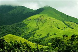
Kushalanagar or Kushalanagara is a city located in the Kodagu district of the Indian state of Karnataka. Surrounded by Kaveri river, it is the gateway to Kodagu district. It also serves as the headquarters of Kushalanagar Taluk. By population, Kushalanagar is the second largest town in Kodagu district after Madikeri and the fastest developing town in the district. Kushalnagar is an important commercial centre in Kodagu.

<span class="mw-page-title-main">History of Kodagu</span>

The district of Kodagu in present-day Karnataka comprises the area of the former princely state of the same name.

<span class="mw-page-title-main">Gonikoppal</span> Town in Karnataka, India

Gonikoppal is a census town in the Kodagu district of the Indian state of Karnataka.

<span class="mw-page-title-main">Sakleshpur</span> Town in Karnataka, India

Sakleshpur, also know as Sakleshpura or Sakleshapura, is a hill station town and headquarters of Sakleshpur taluk in Hassan district in the Indian state of Karnataka.

<span class="mw-page-title-main">Bhagamandala</span> Village in Karnataka, India

Bhagamandala is a pilgrimage place in Kodagu district of the Indian state of Karnataka.

<span class="mw-page-title-main">Transport in Karnataka</span>

Karnataka, a state in South India has a well-developed transport system. Its capital city, Bengaluru is well-connected by air to domestic and international destinations and the Kempegowda International Airport (KIA) in the city is one of the busiest airports in India. It was also the headquarters of the airlines Air Deccan and Kingfisher Airlines. The road transport is also well developed in the state with many National and State highways providing means for fast transportation. The headquarters of the South-Western Railway division of Indian Railways is located at Hubballi and this division governs most of the railway network in the state. Konkan Railway which passes along the coastal region of the state is considered one of the toughest engineering projects being undertaken in India till date. Buses, cars and trains are the means of transport for moving across distant places in Karnataka. For transportation within the city or town limits; motorbikes, cars, autorickshaws and buses are used. With the advent of low-cost airlines, many people are choosing to travel via air as well.

Tulu Gowda and Arebhashe Gowda (Gauda) are primarily found in South Canara District, Kodagu District, Indian state of Karnataka and Bandadka village of Kasaragod. They are a subsect of the Vokkaliga community but are culturally and linguistically different. They speak Tulu and Arebhashe.

Pandyanda I. Belliappa was a Gandhian, a freedom fighter and politician from the erstwhile state of Coorg.

<span class="mw-page-title-main">Kingdom of Coorg</span>

The Kingdom of Coorg was an independent kingdom that existed in India from the 16th century until 1834. It was ruled by a branch of the Ikkeri Nayaka. From 1780 to 1788, the kingdom was occupied by neighbouring Mysore but the Rajah of Coorg was restored by the British and became a protectorate of the British East India Company on 26 October 1790. In 1834, the then Raja of Coorg rebelled against British authority, sparking the Coorg War. The brief conflict led to the British to annex the kingdom in the same year, who transformed the region into a province of British India.

<span class="mw-page-title-main">Transport in Kannur district</span>

Kannur has a good road network connecting to Bangalore, Mangalore, Kodagu and Cochin. The railway station is also well connected to all parts of India. There is new International airport from Kannur opened on 9 December 2018, other nearest airports are at Calicut and Mangalore. Thalassery, Payyanur, Taliparamba and Iritty are the other transport hubs.

<span class="mw-page-title-main">Kabaka Puttur railway station</span> Railway station in Karnataka, India

Kabaka Puttur is a major railway station on Mangalore–Hassan–Mysore line. It is located in Padil,Puttur, Dakshina Kannada district, Karnataka state, India. It consists of two platforms. It is named after two places: Kabaka which is 5 km away from railway station location and Puttur where railway station lies. The railway station lies 1.2 km away from Puttur KSRTC bus stand and 1.1 km away from Puttur–Uppinangadi Main Road

References

  1. "Census Data Handbook 2011" (PDF). Retrieved 1 September 2023.
  2. "Western Ghats, Coorg, Western Ghats, India: Villas and ayurvedic spa in a World Heritage bio-diverse hotspot". 9 July 2019.
  3. "About Coorg". www.coorg.com. Archived from the original on 26 April 2009.
  4. Kushalappa, Mookonda (2018). 1785 Coorg. Madikeri, Kodagu: Codava Makkada Coota.
  5. 1 2 Kushalappa, Mookonda (2013). The early Coorgs. Chennai: Notion Press.
  6. Kushalappa, Mookonda Nitin (2018). Kodagu principality vs British Empire. Madikeri, Kodagu: Codava Makkada Coota.
  7. Kushalappa, Mookonda (2014). Long ago in Coorg. Chennai: Pothi.
  8. Puttur Anantharaja Gowda (2015). IN PURSUIT OF OUR ROOTS.
  9. Jerry Dupont, The Common Law Abroad , Wm. S. Hein Publishing, 2001, ISBN   0-8377-3125-9, from p 592
  10. Kushalappa, Mookonda, Nitin (2018). Kodagu principality vs British empire. Codava Makkada Coota.{{cite book}}: CS1 maint: multiple names: authors list (link)
  11. "Census of India 2001: Data from the 2001 Census, including cities, villages and towns (Provisional)". Census Commission of India. Archived from the original on 16 June 2004. Retrieved 1 November 2008.
  12. Madikeri, FallingRain.com
  13. "Maps, Weather, and Airports for Madikeri, India". www.fallingrain.com.
  14. Ground Water Information Booklet, Ministry of Water Resources, 2007. Retrieved 23 June 2011.
  15. "Station: Madikeri/Mercara Climatological Table 1981–2010" (PDF). Climatological Normals 1981–2010. India Meteorological Department. January 2015. pp. 489–490. Archived from the original (PDF) on 5 February 2020. Retrieved 19 April 2020.
  16. "Extremes of Temperature & Rainfall for Indian Stations (Up to 2012)" (PDF). India Meteorological Department. December 2016. p. M99. Archived from the original (PDF) on 5 February 2020. Retrieved 19 April 2020.
  17. "Annual State Report 2022" (PDF). Retrieved 26 July 2023.