Virajpet

Last updated

Virajpet
Virarajendra Pete
Town
India Karnataka location map.svg
Red pog.svg
Virajpet
Location in Karnataka, India
India location map 3.png
Red pog.svg
Virajpet
Virajpet (India)
Coordinates: 12°12′N75°48′E / 12.2°N 75.8°E / 12.2; 75.8
CountryFlag of India.svg  India
State Seal of Karnataka.svg Karnataka
District Kodagu
Established1792
Founded by Dodda Vira Rajendra
Government
  BodyTown Municipal Council
  PresidentDr.Yathish Ullal K.A.S
  Chief OfficerChandrakumara A.
Area
[1]
  Town9.02 km2 (3.48 sq mi)
  Rural
1,643.61 km2 (634.60 sq mi)
Elevation
909 m (2,982 ft)
Population
 (2011)
  Town17,246
  Density1,900/km2 (5,000/sq mi)
   Rural
184,185
Languages
  Official Kannada [2]
Time zone UTC+5:30 (IST)
PIN
571 218
Telephone code08274
ISO 3166 code IN-KA
Vehicle registration KA-12
Website www.virajpettown.mrc.gov.in

The town of Virajpet also spelled as Virajapete is town of the district of Kodagu, in India's southern State of Karnataka. It is the main town of the Virajpet taluka , south of the district, and borders Kerala State. The name of the town is derived from its founder, Dodda Vira Rajendra.

Contents

History

The name Virajpet is a shorter version of its previous name Virarajendrapet, named after the Haleri King Dodda Vira Rajendra, who founded the town in 1792. [3] He founded the town to commemorate his meeting with General Robert Abercromby, his ally against Tipu Sultan, the ruler of the Kingdom of Mysore, in 1791. Virajpet was the headquarters of Yedenalknad taluk. [4] The first population comprised people who Vira Rajendra had in his predatory excursions swept away from Mysore. But, the people that fled to Virajpet were principally the inhabitants of Periyapatna, who were looking for protection when their town was destroyed by Tipu Sultan, to prevent its falling into the hands of the British. [5]

Lieutenant Connor in his 1870 memoir titled Memoir of the Codugu Survey noted that Virajpet was "a large straggling town containing about 500 houses... and although the whole permanent trade of the country is centered here, there are but few symptoms of either affluence, or growing prosperity; having no manufactures, its chief support must be in traffic, for this, its situation is particularly advantageous, fitting it in a great measure for being a staple between Mysore and the Western coast". He noted that fair takes place every Friday and was "the largest of the periodical markets held in the country". He added, "... all the produce of the southern parts is brought here for sale, also that of the districts in its vicinity, it being the: principal place from which they are exported, the neighbouring inhabitants of Mysore resort here in great number. Rice is the chief article which they take away with them." [5]

During the independence movement, Mahatma Gandhi visited the town in 1934 and addressed a public gathering. [6]

Climate and rainfall

Virajpet has a hot and wet type of climate. The town receives moderately high rainfall. Summer in April and May are hot, with daily maximum temperature reaching over 34 °C. Temperature reduces with the onset of monsoon in the month of June. Winters are cold with daily minimum temperature hovering around 10 °C to 15 °C. In 2022, Virajpet hobli received annual rainfall of 2,587 millimetres (101.9 in). [7] It falls under the drainage basin of west flowing rivers as its terrain is inclined towards the west and contribute less to Kaveri river basin.

Demographics

Virajpet has a population of 17,246 as per the 2011 Census of India. The number of males was 8,724 and females 8,522, thus a gender ration of 977 females to 1,000 males. [8] Virajpet's literacy rate is 93.12 per cent, [8] significantly higher than the national average of 74.04 per cent. The rate among males was 92.75 per cent and 95.46 per cent in females. 1,641 in number, 9.52 per cent of the population fall in the under-six age group. [8]

Religion and language

According to the 2011 Census, 63.43 per cent of the town's population identified themselves as Hindus, 28.80 per cent as Muslims and 7.23 per cent as Christians. Sikhs, Buddhists, Jains formed a small percentage of the population, while 0.14 per cent claimed no religious affiliation. [8]

The most widely spoken languages in Virajpet taluk are Malayalam, Kodava, Kannada and Tulu in descending order.

Languages in Virajpet taluk [9]
LanguageSpeakers
Malayalam
35.5%
Kodava
24.4%
Kannada
21.4%
Tulu
18.7%
Distribution of languages
Source: 2011 Census

Civic administration

Virajpet Town officials [10] [11]
PresidentT. R. Sushmitha
Vice-presidentVinank Kuttappa

The Virajpet Nagar Panchayat is the municipality in charge of the civic and infrastructural assets of the town. Virajpet has a town area of 8.26 km2 (3.19 sq mi). [12] The municipal council consists of 18 elected representatives, called councillors, one from each of the 18 wards (localities) of the town. [13] A councillor from the majority party is selected as a President. The council initially met at the Town Hall, which was built in 1932, before it was expanded in 1956. However, the council then met in another building constructed for the purpose, which also housed the administrative staff associated with the municipality. [14]

For elections to the Lok Sabha, Virajpet falls under the Mysore constituency. Prior to revision of the constituencies by the Delimitation commission in 2008, the town came under Mangalore constituency. [15] For elections to the State Legislative Assembly, the town falls under the constituency that, apart from the town, includes the surrounding villages, and sends one member to the assembly.

Transportation

Both Karnataka and Kerala operate government-run buses to Virajpet towards Kannur, Bengaluru, Ernakulam, Hassan and Madikeri. Intra-district connectivity is maintained by private -run buses. Virajpet does not have railway connectivity. The nearest railway stations are Thalassery and Kannur in Kerala, at a distance of 80 kilometres (50 mi) each. Mysuru is the nearest major railway station in Karnataka at 105 kilometres (65 mi).

The nearest airports are Kannur International Airport in Kerala and Mangalore International Airport at 59 kilometres (37 mi) and 172 kilometres (107 mi) respectively. Also, the Kozhikode International Airport and the Bengaluru Kempegowda International Airport are at a distance of 167 kilometres (104 mi) and 282 kilometres (175 mi) respectively from the town.

Highways

No national highways pass through the town of Virajpet. It can be reached by state highways, SH-90, SH-27 and SH-91.

See also

Related Research Articles

<span class="mw-page-title-main">Kodagu district</span> District of Karnataka in India

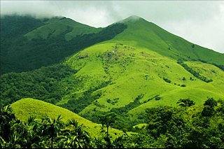
Kodagu district is an administrative district in the Karnataka state of India. Before 1956, it was an administratively separate Coorg State, at which point it was merged into an enlarged Mysore State.

<span class="mw-page-title-main">Madikeri</span> City in Karnataka, India

Madikeri is a hill station town in Madikeri taluk and headquarters of Kodagu district in Karnataka, India. Its original name was Muddurajanakeri which means "the capital of Maharaja Mudduraja".

<span class="mw-page-title-main">Iritty</span> Municipality in Kerala, India

Iritty is a Municipality and a Taluk of Kannur district in Kerala State, India. The town is the main market place for the farmer communities in the surrounding regions. Iritty is known as The Coorg Valley in God's Own Country. Iritty is at a distance of 20 km (12 mi) from Kannur International Airport and one among five taluks in Kannur district. Iritty is one of the major towns lies between Coorg and Kannur international airport -Mattanur.

<span class="mw-page-title-main">Mattanur</span> Municipality in Kerala, India

Mattanur, also spelled Mattannur, is a town, municipality, and an aerotropolis in Kannur district, Kerala, India. Mattanur is about 27 km east of Kannur and Thalassery, two major towns of the district.

<span class="mw-page-title-main">Somwarpet</span> Town in Karnataka, India

Somwarpet is a panchayat town in Kodagu district in the Indian state of Karnataka. It is the main town of the Somwarpet taluk, in the north-east of the district. 2nd highest Administrative town in Karnataka in terms of elevation. The main crops grown in the area are coffee and spice crops such as cardamom, peppers, oranges, ginger and vegetables.

<span class="mw-page-title-main">Peravoor</span> Town in Kerala, India

Peravoor is a town and Grama Panchayat in Kannur district of Kerala state in India. It is located 50 km (31 mi) east of Kannur and 40 km (25 mi) north east of Thalassery. And Iritty, the nearest municipality is 14 km (8.7 mi) north of Peravoor. Peravoor is situated in the Western Ghats mountain range.

<span class="mw-page-title-main">Kushalanagar</span> Town in Karnataka, India

Kushalanagar or Kushalanagara is a city located in the Kodagu district of the Indian state of Karnataka. Surrounded by Kaveri river, it is the gateway to Kodagu district. It also serves as the headquarters of Kushalanagar Taluk. By population, Kushalanagar is the second largest town in Kodagu district after Madikeri and the fastest developing town in the district. Kushalnagar is an important commercial centre in Kodagu.

<span class="mw-page-title-main">History of Kodagu</span>

The district of Kodagu in present-day Karnataka comprises the area of the former princely state of the same name.

<span class="mw-page-title-main">Gonikoppal</span> Town in Karnataka, India

Gonikoppal is a census town in the Kodagu district of the Indian state of Karnataka.

<span class="mw-page-title-main">Sreekandapuram</span> Municipality in Kerala, India

Sreekandapuram is a municipality in Kannur district, in the Indian state of Kerala.

<span class="mw-page-title-main">Bhagamandala</span> Village in Karnataka, India

Bhagamandala is a pilgrimage place in Kodagu district of the Indian state of Karnataka.

<span class="mw-page-title-main">Irupu Falls</span> Waterfall in Karnataka, India

The Irupu Falls are located in the Brahmagiri Range in the Kodagu district of Karnataka, India, bordering the Wayanad district of Kerala. It is a fresh water cascade and is situated at a distance of 48 km from Virajpet on the highway to Nagarhole. The falls are also known as the Lakshmana Tirtha Falls, derived from the name of the tributary of Cauvery which starts from these falls, the Lakshmana Tirtha River.

<span class="mw-page-title-main">Cherupuzha, Kannur</span> Town in Kerala, India

Cherupuzha is a town in Kannur district, Kerala, India. It is the headquarters of the Cherupuzha Panchayat which is a special grade panchayat in Kerala.

<span class="mw-page-title-main">Honnamana Kere</span> Town in Karnataka, India

Honnamana Kere is a lake and holy place in Doddamalthe near the village of Sulimalthe, 6 km away from Somwarpet town of Coorg in the state of Karnataka, India. It is the biggest lake in Kodagu, and once a year, during the Gowri festival, a special pooja is conducted and a 'Bagina' which consists of the belongings of goddess Honamma is presented to the lake.

Mangalore Lok Sabha constituency was one of the Lok Sabha constituencies in Karnataka state in southern India. With the implementation of the delimitation of parliamentary constituencies in 2008, based on the recommendations of the Delimitation Commission of India constituted in 2002, this constituency ceased to exist.

<span class="mw-page-title-main">Kingdom of Coorg</span>

The Kingdom of Coorg was an independent kingdom that existed in India from the 16th century until 1834. It was ruled by a branch of the Ikkeri Nayaka. From 1780 to 1788, the kingdom was occupied by neighbouring Mysore but the Rajah of Coorg was restored by the British and became a protectorate of the British East India Company on 26 October 1790. In 1834, the then Raja of Coorg rebelled against British authority, sparking the Coorg War. The brief conflict led to the British to annex the kingdom in the same year, who transformed the region into a province of British India.

<span class="mw-page-title-main">Somwarpet taluk</span> Taluk in Karnataka

Somawarpete taluk is one of the five taluks of Kodagu district. Its administrative headquarters is in the town of Somwarpet.

Coorg was a constituency of the Lok Sabha. It was used in the parliamentary election of 1951–1952. The constituency elected a single member of the Lok Sabha and was the sole Lok Sabha seat for the Coorg State. As of 1952, the constituency had 94,593 eligible voters.

<span class="mw-page-title-main">Attur, Somwarpet</span> Village in Karnataka, India

Attur Nallur is a small village in Somwarpet Taluk in Kodagu District of Karnataka State, India. It comes under Attur Nallur Panchayath. It belongs to Mysore Division. It is located 12 km to the east of District headquarters Madikeri. 28 km from Somvarpet and 234 km from state capital Bangalore.

Dodda Vira Rajendra was the ruler of the Kingdom of Coorg from 1780 to 1809. He is considered a hero of Coorg history for having freed the kingdom from the occupation of Tipu Sultan, the king of Mysore. He later aided the British in their fight against Tipu Sultan.

References

  1. "Virajpet Town Population 2011", citypopulation.de
  2. "THE KARNATAKA OFFICIAL LANGUAGE ACT, 1963" (PDF). Government of Karnataka. Retrieved 23 February 2017.
  3. "A melting pot of cultures". Deccan Herald. 19 December 2011. Archived from the original on 24 February 2017. Retrieved 24 February 2017.
  4. Rice, Lewis (1878). "History of Coorg". Mysore and Coorg, A Gazetteer compiled for the Government, Volume 3, Coorg. Bangalore: Mysore Government Press. p. 423.
  5. 1 2 Memoir of the Codugu Survey. 1870. p. 19. Retrieved 27 March 2024.
  6. Gowda, Chandan (28 September 2019). "When Coorg got a glimpse of Gandhi's moral vision". Deccan Herald. Retrieved 27 March 2024.
  7. "Annual State Report 2022" (PDF). Retrieved 14 July 2023.
  8. 1 2 3 4 "Virajpet Population Census 2011". census2011.co.in. Retrieved 23 February 2017.
  9. "Census of India - Language". censusindia.gov.in. Retrieved 17 April 2020.
  10. "Virajpet and Somwarpet Town Panchayat heads elected". Deccan Herald. Retrieved 27 March 2024.
  11. "Vinank Kuttappa elected as vice president of Virajpet TP". Deccan Herald. Retrieved 27 March 2024.
  12. "Virajpet Town Panchayat About Us". virajpettown.mrc.gov.in. Retrieved 23 February 2017.
  13. "Delimitation of Wards" (PDF). virajpettown.mrc.gov.in. 21 February 2017. Retrieved 23 February 2017.
  14. Sathyan, B. N. Sri (1965). Gazetteer of India: Coorg District. p. 382. Retrieved 27 March 2024.
  15. "Kodagu voters end up in Mysore". Business Standard. 22 April 2009. Archived from the original on 23 February 2017. Retrieved 23 February 2017.