Periyapatna

Last updated

Periyapatna
Singapatna
Town
Piriyapatna
Periyapatna (Taluk) 2011.jpg
Periyapatna Taluk Map
India Karnataka location map.svg
Red pog.svg
Periyapatna
Location in Karnataka, India
Coordinates: 12°20′11″N76°04′45″E / 12.33649°N 76.07918°E / 12.33649; 76.07918
CountryFlag of India.svg  India
State Karnataka
District Mysuru
Founded byPeriya Raja
Named for Periya Raja
Government
  Type Town Municipal Council
  BodyPeriyapatna Town Municipal Council
Area
  Town12.5 km2 (4.8 sq mi)
  Rural
808.20 km2 (312.05 sq mi)
Elevation
852 m (2,795 ft)
Population
 (2011)
  Town16,685
  Density1,300/km2 (3,500/sq mi)
   Rural
226,391
Languages
  Official Kannada
Time zone UTC+5:30 (IST)
PIN
571107
Telephone code08223
Vehicle registration KA-45
Nearest cities Kushalanagara, Mysore
Climate Tropical wet and dry (Köppen)

Periyapatna is a town located in Mysore district. Periyapatna is also known for being one of the largest producers of high-quality tobacco, so it is called the land of tobacco and there is a popular temples in Periyapatna, the Kannambadi Amma and Masanikamma temples which are frequented by the villagers.

Contents

Location

Periyapatna Vidhana Sabha Constituency marks the boundary of Periyapatna Taluk Periyapatna (Taluk) Vidhana Sabha Constituency.jpg
Periyapatna Vidhana Sabha Constituency marks the boundary of Periyapatna Taluk

Periyapatna is located at 12°20′N76°06′E / 12.34°N 76.1°E / 12.34; 76.1 . [1] It has an average elevation of 852 metres (2,795 ft) above mean-sea-level. The town is situated on Bengaluru-Mysuru-Mangaluru Highway at a distance of 70 km from Mysuru. The town is nearby Kushalanagar of Kodagu district.

> There is a mini Tibet, hosting the world’s second-largest Tibetan settlement (Dharamsala in Himachal Pradesh has the largest Tibetian settlement) Bylakuppe Town Periyapatna Taluk Karnataka.

> In the 1960s, when China invaded Tibet, nearly 1 lakh Tibetans were tragically killed within two and a half years.

> Around 98% of the monasteries were destroyed, erasing the local culture.

> In response, many Tibetan refugees sought shelter in India, including their leader Dalai Lama.

> He requested the Indian government to provide a place for Tibetan refugees in India.

> The then Karnataka Chief Minister, S Nijalingappa, allocated 3,000 acres of land in Mysuru district’s Bylakuppe town.

> Today, more than 20,000 Tibetans live there happily, preserving their culture.

> There is hope that one day, Tibetans will return to their homeland, as expressed by a settler in Bylakuppe, Mr. Dorji: “If we become Indian citizens, it will impact the Tibetan freedom struggle. There is still hope for the struggle among a majority of the Tibetan people.”

Rehabilitation

Schema has been sanctioned for the rehabilitation of East Pakistan displaced person in Periyapatna taluk and not Periyapatna town. Around 800 agriculturist families settled there. It will cost about this Rs 4,000 per family. The cost of the entire scheme is borne by the Central Government. The state government for the moment has offered about 8,000 acres of land, and we are told that the area is covered with forests. Six acres of land will be given to each family and according to the State Government, it will be quite sufficient for any agriculturist family. [2] The scheme has been dropped. [3]

Places of interest

Mysore-Bylakuppe-Golden Temple.JPG

The temple of Aprameya was built in the 11th century by Chola emperor Rajendra Simha. The temple is named after the invading Chola general Aprameya. The idol of Ambegalu Navaneetha Krishna (crawling Krishna with butter in hand), is believed to be the only deity of Lord Sri Krishna in this pose. This idol was installed by Vyasaraja (aka Vyasatirtha), who was a prominent saint of Dvaita Vedanta. The famous Kriti (musical composition or song) "Jagadodharana Adisidale Yashode" was composed by most prominent composer of Carnatic music Purandaradasa in appreciation of the beauty of this idol. [4]

Bylakuppe Tibetian settlement is located in this taluk and it is a home to around 70,000 Tibetians. The town is mainly inhabited by Tibetans who, according to a demographic survey carried out by the Central Tibetan Administration's Planning Commission in 1998, accounted for 50,727 individuals at that time. However, it is unclear whether these figures included the Vajrayana Buddhist monks living there. Today, an estimated 70,000 Tibetans live in the settlements; these were established on land leased by the state government to accommodate some of the Tibetan expatriates who came to resettle in India after 1959. Bylakuppe consists of a number of agricultural settlements, colonies are close to each other, and has number of monasteries and temples in all the major Tibetan Buddhist traditions. Most notable among them are the large educational monastic institution Sera Monastery, the smaller Tashi Lhunpo Monastery (both in the Gelug tradition) and Namdroling Monastery (in the Nyingma tradition). Bylakuppe also has many Buddhist universities for advanced Buddhist practices.

Demographics

Religions in Periyapatna Taluk
ReligionPercent
Hinduism
87.70%
Islam
8.68%
Buddhism
1.31%
Christianity
1.31%
Other or not stated
0.29%

As per the Population Census 2011, there are total 4,031 families residing in the Piriyapatna city. The total population of Piriyapatna is 16,685 out of which 8,284 are males and 8,401 are females thus the Average Sex Ratio of Piriyapatna is 1,014.

The population of Children of age 0–6 years in Piriyapatna city is 1851 which is 11% of the total population. There are 946 male children and 905 female children between the age 0–6 years. Thus as per the Census 2011 the Child Sex Ratio of Piriyapatna is 957 which is less than Average Sex Ratio (1,014).

As per the Census 2011, the literacy rate of Piriyapatna is 80.8%. Thus Piriyapatna has higher literacy rate compared to 72.8% of Mysore district. The male literacy rate is 86.56% and the female literacy rate is 75.27% in Piriyapatna. [5]

Languages of Periyapatna

   Kannada (85.82%)
   Urdu (10.18%)
  Others (5%)

Vokkaliga Gowda community forms the highest population of the Taluk and majorly are tobacco cultivators. Also it is the homeland for Majority of Minor Tribal group Beda Nayakas (ST-Hunting tribal groups..also called as Valmiki Nayakas) vowing to thick Malanad forest around and Hunting being their occupation. As of 2001 India census, [6]

Related Research Articles

<span class="mw-page-title-main">Chendamangalam</span> Town in Kerala, India

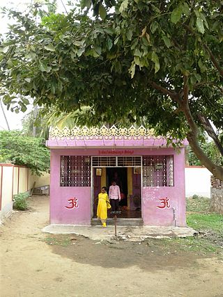
Chendamangalam is a small town and a panchayat in Paravur Taluk, Ernakulam district in the state of Kerala, India.

<span class="mw-page-title-main">Madikeri</span> City in Karnataka, India

Madikeri is a hill station town in Madikeri taluk and headquarters of Kodagu district in Karnataka, India. Its original name was Muddurajanakeri which means "the capital of Maharaja Mudduraja".

<span class="mw-page-title-main">Yelandur</span> Town in Karnataka, India

Yelandur is a taluk and town in Chamarajanagar district in southern Karnataka, India. It has historic and cultural importance in this region. Along with three other taluks, it was officially included into Chamarajanagar district when the district was notified upon bifurcation of Mysore district in 1997.

Mulabagilu is a town and administrative center of Mulabagilu taluk, in the Kolar district in the state of Karnataka, India. The town is situated on the National Highway 75 and is the easternmost town of the state.

<span class="mw-page-title-main">Bylakuppe</span> Town in Karnataka, India

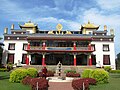
Bylakuppe is an area in Karnataka which is home to the Indian town Bylakuppe and several Tibetan settlements, established by Lugsum Samdupling and Dickyi Larsoe. Bylakuppe is the largest Tibetan settlement in the world outside Tibet. It is located to the west of Mysore district in the Indian state of Karnataka which is roughly 80 km from Mysore city.

Chitapur or Chittapur is a town and taluk in Kalaburagi district in the state of Karnataka, India. It is also the headquarters of the Chittapur taluk. It is known for polished stones and toor dal.

<span class="mw-page-title-main">Kudavasal</span> Town in Tamil Nadu, India

Kudavasal or Kodavasal is a panchayat in Thiruvarur district in the Indian state of Tamil Nadu. The town is the headquarters of Kudavasal taluk.

<span class="mw-page-title-main">Maddur, Mandya</span> Town in Karnataka, India

Maddur is a town in Mandya district in the Indian state of Karnataka. It lies on the banks of the river Shimsha. It is 82 kilometers from the state capital Bangalore and 60 kilometers from Mysore. Derived from Maddu a term referring to chemicals used for explosives.

<span class="mw-page-title-main">Mundgod</span> Town in Karnataka

Mundgod is a town in Uttara Kannada district of Karnataka state in India, Mundgod is known for its Tibetan Colony; it is also known as Mini Tibet.

<span class="mw-page-title-main">Nagamangala</span> Town in Karnataka, India

Nagamangala is a PuraSabhe and a taluk in Mandya district, in the Indian state of Karnataka.

Nilakkottai is a town in the Dindigul district of the Indian state of Tamil Nadu. The town was established in 1958, as 1st Grade Town Panchayat. In 1970, it was changed to Selection Grade. The Town Panchayat has been under the municipal act since 1996. In 2004, it was called Special Village Panchayat, and in 2006, Selection Grade Town Panchayat.

Pullambadi is a Panchayat town in Tiruchirappalli district in the Indian state of Tamil Nadu. Pullambadi town panchayat heads the revenue block of Pullambadi in the taluk of Lalgudi.

<span class="mw-page-title-main">Rewalsar, India</span> Town in Himachal Pradesh, India

Rewalsar or Tso Pema in Tibetan is a small town and a pilgrimage place in a nagar panchayat in Mandi district in India. It is located in the state of Himachal Pradesh. The local name for Rewalsar is Tri Sangam. Rewalsar Lake is a tourist spot in the area.

<span class="mw-page-title-main">Tegar</span> Village in Ladakh, India

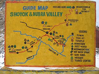
Tegar, also known as Kyagar, is a high-altitude village in the Leh district of Ladakh, India. It is located in the Nubra tehsil, in the Nubra Valley.

<span class="mw-page-title-main">Namdroling Monastery</span> Tibetan Buddhist monastery in Bylkuppe, Karnataka, India

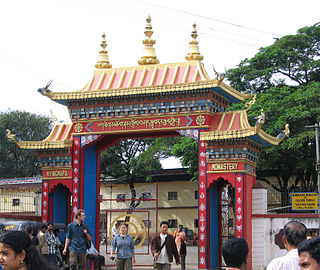
The Namdroling Nyingmapa Monastery or Thegchog Namdrol Shedrub Dargye Ling(བོད་ཡིག ཐེག་མཆོག་རྣམ་གྲོལ་བཤད་སྒྲུབ་དར་རྒྱས་གླིང་།), or ನಮ್ಡ್ರೋಲಿಂಗ್ ವಿಹಾರ is the largest teaching center of the Nyingma lineage of Tibetan Buddhism in the world. Located in Bylakuppe, part of the Mysuru district of the state of Karnataka, the monastery is home to a sangha community of over five thousand lamas, a junior high school named Yeshe Wodsal Sherab Raldri Ling, a religious college and hospital.

There is a small Mongolian community in India, comprising mostly Buddhist monks and scholars as well as international students from Mongolia.

<span class="mw-page-title-main">Saligrama, Mysore</span> Town in Karnataka, India

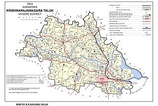
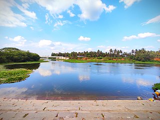
Saligrama is a new sub-district of Mysore district, situated on the northern bank of the river Cauvery [Kaveri]. This place is esteemed as sacred by the Shri Vaishnavas on account of its having been the residence of Sri Ramanujacharya. It is the headquarters of Saligrama Taluk. It was established as a new taluk carving out of K.R.Nagar taluk with effect from 31.12.2020 and become ninth taluk of Mysore district of Karnataka, India.

Alathur is a village in the Mannargudi taluk of Tiruvarur district in Tamil Nadu, India.

<span class="mw-page-title-main">Sagara, Karnataka</span> City in Karnataka, India

Sagara is a city located in the Indian state of Karnataka. It is also a sub divisional and a taluk headquarters. Located in the Sahyadri Mountain range on the banks of river Varada, it is known for its proximity to Jog Falls and to the historical places of Ikkeri, Keladi and Varadamoola. The river Varada originates near Varada-moola. Sagara subdivision consists of Sagara, Soraba, Hosanagara and Shikaripur taluks.

<span class="mw-page-title-main">Mysore–Bangalore line</span> Railway line in India

Mysore–Bangalore line is a fully electrified double line from Mysore Junction to Bangalore City.

References

  1. Falling Rain Genomics, Inc – Piriyapatna
  2. https://eparlib.nic.in/bitstream/123456789/1738/1/lsd_02_05_12-09-1958.pdf page 15
  3. https://eparlib.nic.in/bitstream/123456789/1589/1/lsd_02_06_17-11-1958.pdf page 42
  4. "TMC Website".
  5. "Census 2011 Handbook" (PDF).
  6. "Census of India 2001: Data from the 2001 Census, including cities, villages and towns (Provisional)". Census Commission of India. Archived from the original on 16 June 2004. Retrieved 1 November 2008.