Madikeri is a hill station town in Madikeri taluk and headquarters of Kodagu district in Karnataka, India. Its original name was Muddurajanakeri which means "the city of Mudduraja".

Nedumangad is a municipal town in the Thiruvananthapuram district in the Indian state of Kerala. It is the headquarters of Nedumangad Tehsil and Nedumangad Revenue Division. It is a suburb of the extended metropolitan region of Thiruvananthapuram. It is located around 16 km (9.9 mi) to the north-east of Thiruvananthapuram on the State Highway 2. It is an important commercial center in the district. It is a growing commercial and educational hub and all important government institutions are situated in the town. The Nedumangadu market has significance in southern Kerala.

Iritty is a Municipality and a Taluk of Kannur district in Kerala State, India. The town is the main market place for the farmer communities in the surrounding regions. Iritty is known as The Coorg Valley in God's Own Country. Iritty is at a distance of 20 km (12 mi) from Kannur International Airport and one among five taluks in Kannur district. Iritty is one of the major towns lies between Coorg and Kannur international airport -Mattanur.
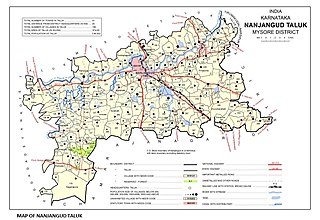
Nanjangud, officially known as Nanjanagudu, is a town in the Mysuru district of the Indian state of Karnataka. Nanjangud lies on the banks of the river Kapila, 23 km from the city of Mysore. Nanjangud is famous for the Srikanteshwara Temple located here. Nanjangud is also called Dakshina Kashi. This town is also famous for a type of banana grown in the region called the Nanjanagoodu rasabale. Nanjangud's local administrative unit was designated as a Municipal Committee in 2015 by including Devirammanahalli and Kallahalli village.

Mysore division, officially Mysuru division, is an administrative division in the southern Indian state of Karnataka. It is one of four administrative divisions in Karnataka, the others being Bangalore division, Belagavi division, and Kalaburagi division. Mysore division comprises eight districts of Karnataka, namely, Chamarajanagar, Chikmagalur, Dakshina Kannada, Hassan, Kodagu, Mandya, Mysore and Udupi district. The city of Mysore is the administrative headquarters of the division. Mysore division covers parts of historical Old Mysore region and southern part of Coastal Karnataka.The total area of the division is 43,503 sq.km. The total population as of 2011 census is 12,563,598.

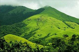
Kushalanagar or Kushalanagara is a city located in the Kodagu district of the Indian state of Karnataka. Surrounded by Kaveri river, it is the gateway to Kodagu district. It also serves as the headquarters of Kushalanagar Taluk. By population, Kushalanagar is the second largest town in Kodagu district after Madikeri and the fastest developing town in the district. Kushalnagar is an important commercial centre in Kodagu.

Kollegala is the Major taluk in the Chamarajanagara District of Karnataka State in the south of India. Kollegala is well known for its silk industry which attracts traders from all over the state.

Ulikkal is a growing town in Kannur District in Kerala. It is the HQ of Ulikkal Grama Panchayat in Iritty Taluk. Kerala State Hill highway SH 59 passes through Ulikkal Town.

Holenarasipura is a town and taluk in Hassan district of Karnataka. The town is situated on the banks of the Hemavati, one of the tributaries of the Kaveri.

Gonikoppal is a census town in the Kodagu district of the Indian state of Karnataka.

Peralasseri is a census town and Panchayat headquarters in Kannur district in the Indian state of Kerala, situated on the Kannur-Kuthuparamba State Highway 38 (Kerala), 12 km from Kannur city, on the bank of Anjarakandy river.
Meppayur is a town in Kozhikode district of Kerala state, South India.
Perunad (Ranni-Perunad) is a scenic hilly village in Pathanamthitta district, Kerala state, India. Thiruvalla is the nearest railway station located at a distance of 58 km (36 mi). It's located on the banks of Pamba River and Kakkad River.

Kutta is a small village in Ponnampet taluk of Kodagu, in Karnataka state of India. As per census survey 2011, location code number of Kutta is 618078.

Thamarassery, formerly known as Thazhmalachery, is one of the taluks and a major hill town in the Kozhikode district of Kerala, India, 30 km north-east of Kozhikode (Calicut) city and 29 km east of Koyilandy. The town lies on National highway 766.
Kadakola is a Town and a suburb of Mysuru metropolitan area in the southern state of Karnataka, India. It is located in the Mysore taluk of Mysore district. In November 2020, Kadakola was upgraded from a Gram Panchayat to a Town Panchayat and a gazetted notification was passed on November 26, 2020.2. The combined population of the newly formed town is 19,969.
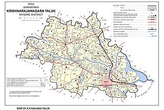
Saligrama is a new sub-district of Mysore district, situated on the northern bank of the river Cauvery [Kaveri]. This place is esteemed as sacred by the Shri Vaishnavas on account of its having been the residence of Sri Ramanujacharya. It is the headquarters of Saligrama Taluk. It was established as a new taluk carving out of K.R.Nagar taluk with effect from 31.12.2020 and become ninth taluk of Mysore district of Karnataka, India.

The Keladi Shivappa NayakaUniversity of Agricultural and Horticultural Sciences, Shimoga(KSNUAHS) is a university in the Indian state of Karnataka. It is the state's first integrated university to have both agricultural and horticultural sciences under its purview.

Kattikkulam (Kartikulam) is a small town near Mananthavady in Wayanad district, Kerala, India.The office of the Thirunelly Gramapanchayath is located at Kartikulam.

Kayakkunnu is a village near Nadavayal, Mananthavady in the Wayanad District of Kerala, India. The village is part of the Panamaram Panchayath, and the assembly constituency is Mananthavady. It is an agricultural area and its main crops include rice, coffee, pepper, ginger, cardamom, vanilla, rubber, areca nut, and coconut. The nearest towns are Nadavayal and Panamaram. Kayakkunn is situated midway along the Mananthavady–Gudalur interstate road.


