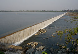
Lower Manair Dam | |
---|---|
Official name | Lower Manair Dam |
Location | Karimnagar district, Telangana, India |
Coordinates | 18°23′59″N79°7′52″E / 18.39972°N 79.13111°E |
Opening date | 1985 |
Owner(s) | Government of Telangana |
Dam and spillways | |
Impounds | Manair River |
Height | 41 metres (135 ft) from river level |
Length | 10,741 metres (35,240 ft) |
Reservoir | |
Creates | Lower Manair Reservoir |
Total capacity | 680,137,000 m3 (551,396 acre⋅ft) (24.02 tmc ft) |
Active capacity | 621,000,000 m3 (503,453 acre⋅ft) (21.9 tmc ft) [1] |
Catchment area | 6,648 square kilometres (2,567 sq mi) |
Surface area | 81 km2 (31 sq mi) |
Lower Manair Dam also known as LMD [2] was constructed across the Manair River, at Alugunur village, Thimmapur mandal, Karimnagar District, in the Indian state of Telangana during 1974 to 1985. It provides irrigation to a gross command area of 163,000 hectares (400,000 acres). [3]
The Lower Manair Dam is located on the Manair River at 18°24' N latitude and 79° 20' E longitude in Karimnagar District at Km.146 of Kakatiya Canal. The Manair River is a tributary of the Godavari River and the dam is built across the river at the confluence with Mohedamada River. The dam drains a catchment area of 6,464 square kilometres (2,496 sq mi) which includes 1,797.46 square kilometres (694.00 sq mi) of free catchment and the balance is intercepted catchment. [4] [5] Karimanagar town is 6 kilometres (3.7 mi) away from the dam. [6]
In the vicinity of the LMD which is the only place of recreation for the people of Karimnagar, in the light of recent drowning incidents and the insecurity created by hooligans, security measures have been stepped up. [7]
Lower Manair Dam's construction was started in 1974 and commissioned in 1985. It is an Earth cum Masonry dam. The dam height above the deepest foundation is 41 metres (135 ft); the maximum height of the earth dam is 88 feet (27 m). The dam length is 10,471 metres (34,354 ft), top width is 24 feet (7.3 m). It has a volume content of 5.41 million cum with a reservoir water spread area of 81 square kilometres (31 sq mi) at FRL of 280 m (920 ft). The gross storage capacity of the reservoir is 680 million cubic meters and the effective storage capacity is 621 million cubic meters (Mcm). The spillway is designed for discharge of capacity 14,170 cubic metres (500,000 cu ft)/ second (and is controlled by 20 gates [6] of 15.24 by 7.31 metres (50.0 ft × 24.0 ft) size, [5] while the maximum observed flood discharge is reported to be 9,910 cubic metres (350,000 cu ft)/second. [4] [8]
The storage behind the dam serves as a balancing reservoir for the Kakatiya Canal and regulates flow for irrigation. [9] The command area for irrigation is 163,000 hectares (400,000 acres).
The water quality status of the Lower Manair Reservoir was studied from September 2009 to August 2010 for the physico- chemical parameters such as water temperature, pH, turbidity, transparency, total dissolved solids, total hardness, chlorides, phosphate, nitrates, dissolved oxygen (DO) and biological oxygen demand (BOD). The results indicated that all parameters of water quality were within permissible limits and it was concluded that the water in the reservoir was fit for use for irrigation, drinking water supply and pisciculture. [10]
Studies were conducted in the LMD reservoir from June 2013 to May 2014 to identify the larvivorous activity of fishes. On the basis of morphometric and meristematic characters, the 58 fish species are identified in the reservoir. Also reported were 53 ornamental fish species comprising eight orders; of these 23 species belong to cypriniformes order. Awaous grammepomus, also called Scribbled goby was also identified. [2]
The Godavari is India's second longest river after the Ganga River and drains the third largest basin in India, covering about 10% of India's total geographical area. Its source is in Trimbakeshwar, Nashik, Maharashtra. It flows east for 1,465 kilometres (910 mi), draining the states of Maharashtra (48.6%), Telangana (18.8%), Andhra Pradesh (4.5%), Chhattisgarh (10.9%) and Odisha (5.7%). The river ultimately empties into the Bay of Bengal through an extensive network of distributaries. Measuring up to 312,812 km2 (120,777 sq mi), it forms one of the largest river basins in the Indian subcontinent, with only the Ganga and Indus rivers having a larger drainage basin. In terms of length, catchment area and discharge, the Godavari is the largest in peninsular India, and had been dubbed as the Dakshina Ganga.
The Dowleswaram Barrage was an irrigation structure originally built in 1852 on the lower stretch of the Godavari River before it empties into the Bay of Bengal. It was rebuilt in 1970 when it was officially renamed as Sir Arthur Cotton Barrage or Godavari Barrage.
The Godavari River has its catchment area in seven states of India: Maharashtra, Telangana, Chhattisgarh, Madhya Pradesh, Andhra Pradesh, Karnataka and Odisha. The number of dams constructed in Godavari basin is the highest among all the river basins in India. Nearly 350 major and medium dams and barrages had been constructed in the river basin by the year 2012.
The Balimela Reservoir is located in Malkangiri district, Odisha, India on the river Sileru which is a tributary of the Godavari river. The gross storage capacity of Balimela reservoir is 3610 million cubic meters.
Nizam Sagar Dam is an Indian dam named after the Nizam of Hyderabad. It is a reservoir constructed across the Manjira River, a tributary of the Godavari River, between Achampet and BanjePally villages of the Kamareddy district in Telangana, India. It is located at about 144 km (89 mi) north-west of Hyderabad. Nizam Sagar is the oldest dam in the state of Telangana.
The Sriram Sagar Project is also known as the Pochampadu Project is an Indian flood-flow project on the Godavari. The Project is located in Nizamabad district, 3 km away from National Highway 44. It has been described by The Hindu as a "lifeline for a large part of Telangana".
The Gandhi Sagar Dam is one of the four major dams built on India's Chambal River. The dam is located in the Mandsaur district of the state of Madhya Pradesh. It is a masonry gravity dam, standing 62.17 metres (204.0 ft) high, with a gross storage capacity of 7.322 billion cubic metres from a catchment area of 22,584 km2 (8,720 sq mi). The dam's foundation stone was laid by Prime Minister of India Pandit Jawaharlal Nehru on 7 March 1954, and construction of the main dam was done by leading contractor Dwarka Das Agrawal & Associates and was completed in 1960. Additional dam structures were completed downstream in the 1970s.
Nagarjuna Sagar Dam is a masonry dam across the Krishna River at Nagarjuna Sagar which straddles the border between Palnadu district in Andhra Pradesh and Nalgonda district in Telangana. The dam provides irrigation water to the districts of Krishna, Guntur, Palnadu, Prakasam and parts of West Godavari districts of Andhra Pradesh and also combined Nalgonda, Khammam districts of Telangana. It is also a source of electricity generation for the national grid.
The Srisailam Dam is constructed across the Krishna River in Nandyal district, Andhra Pradesh and Nagarkurnool district, Telangana near Srisailam temple town and is the 2nd largest capacity working hydroelectric station in India.
The River Nagavali also known as Langulya is one of the main rivers of Southern Odisha and Andhra States in India, between Rushikulya and Godavari basins.
River Vamsadhara or River Banshadhara is an important east flowing river between Rushikulya and Godavari, in Odisha and Andhra Pradesh states in India.
The Jawahar Sagar Dam is the third dam in the series of Chambal Valley Projects on the Chambal River, located 29 km upstream of Kota city and 26 km downstream of Rana Pratap Sagar dam. It is a concrete gravity dam, 45 meters high and 393 meters long, generating 60 MW of power with an installed capacity of 3 units of 33 MW. Its construction was completed in 1972. The dam's gross storage capacity is 67.07 million cubic meters. The total catchment area of the dam is 27,195 km2, of which only 1,496 km2 are in Rajasthan. The free catchment area below Rana Pratap Sagar dam is 2,331 km2. The dam is located after the Gandhi Sagar Dam and Rana Pratap Sagar Dam, but before the Kota Barrage.
The Upper Wardha Dam is an earthfill straight gravity dam across the Wardha River, a tributary of the Godavari River, near Simbhora village in Morshi taluk in Amravati district in the Indian state of Maharashtra. The dam provides multipurpose benefits of irrigation, drinking water supply, flood control and hydropower generation.
The Polavaram Project is an under construction multi-purpose irrigation project on the Godavari River in the Eluru District and East Godavari District in Andhra Pradesh. The project has been accorded National project status by the Central Government of India. Its reservoir back water spreads up to the Dummugudem Anicut and approx 115 km on Sabari River side. Thus back water spreads into parts of Chhattisgarh and Odisha States. It gives major boost to tourism sector in Godavari Districts as the reservoir covers the famous Papikonda National Park, Polavaram hydro electric project (HEP) and National Waterway 4 are under construction on left side of the river. It is located 40 km to the upstream of Sir Arthur Cotton Barrage in Rajamahendravaram City and 25 km from Rajahmundry Airport.
The Pranahita Chevella Lift Irrigation Project is a lift irrigation project to harness the water of Pranahita tributary of Godavari River for use in the Telangana state of India. The river water diversion barrage across the Pranahita River is located at Thammidihatti village in Komaram Bheem district of Telangana. This lift canal is an inter river basin transfer link by feeding Godavari River water to Krishna River basin. The chief ministers of Telangana and Maharashtra states reached an agreement in 2016 to limit the full reservoir level (FRL) of the barrage at 148 m msl with 1.85 tmcft storage capacity. In the year 2016, this project is divided into two parts. The scheme with diversion canal from the Thammmidihatti barrage to connect to existing Yellampalli reservoir across the Godavari River is presently called Pranahita barrage lift irrigation project. This scheme is confined to providing irrigation facility to nearly 2,00,000 acres in Adilabad district using 44 tmcft water.
The Pulichintala Project is a multi-purpose water management project for irrigation, hydropower generation, and flood control in the state of Andhra Pradesh, India. It is a crucial irrigation facility for farmers in four coastal districts: West Godavari, Krishna, Guntur, Palanadu, and Prakasam, covering over 13 lakh acres. It has 24 gates and a balancing reservoir with a capacity of 46 Tmcft at 175 feet (53 m) MSL full reservoir level (FRL).
Sripada Yellampalli Project is an Irrigation project located at Yellampalli Village of Ramagundam rural Mandal, between Peddapalli district - Mancherial District of Telangana State, India. The project is fourth largest on the Godavari River in Telangana State. It is named after late legislator, D. Sripada Rao.
Icchampally Project was a multi-purpose project proposed in 2008, with hydro electricity generation, irrigation, flood control, etc. benefits on the River Godavari in India. This project is proposed as joint project of Telangana, Maharashtra and Chhattisgarh states.
SRSP Flood Flow Canal also known as Sriram Sagar Flood Flow Canal, is a 130 km long gravity canal from Sriram Sagar Project, Village & Mandal Mupkal, Nizamabad District to Mid Manair Dam, Manwada Village, Karimnagar District, Telangana.
Pattiseema Lift Irrigation Project is a river interlinking project which connects Godavari River to Krishna River. This project has thereby become the first of such irrigation type projects in the country to be completed in time without any budget enhancements. It also holds a record in Limca Book of Records. The project was Inaugurated by the Chief Minister of Andhra Pradesh Nara Chandrababu Naidu in March 2016 while the project was completed in one year record of time.