Maldevi River

Last updated

The River Maldevi, and a bridge, in Yellayapalem River Maldevi at Yellayapalem.jpg
The River Maldevi, and a bridge, in Yellayapalem

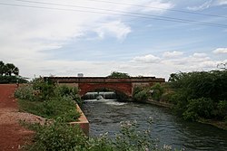
The Maldevi is a river which runs through the Nellore district in the Indian state of Andhra Pradesh. It empties into the Pennar river. [1]

The Vijayanagara empire built the Anantraj Sagar water storage tank using a 1.37 km long dam on this river. [2]

Related Research Articles

<span class="mw-page-title-main">Nellore</span> City in Andhra Pradesh, India

Nellore is a city located on the banks of Penna River, in Nellore district of the Indian state of Andhra Pradesh. It serves as the headquarters of the district, as well as Nellore mandal and Nellore revenue division. It is the fourth most populous city in the state. It is at a distance of 700 km from Visakhapatnam and about 170 km north of Chennai, Tamil Nadu and also about 380 km east-northeast of Bangalore, Karnataka.

<span class="mw-page-title-main">Coastal Andhra</span> Geographic region of Andhra Pradesh in India

Coastal Andhra or Kosta Andhra is a geographic region in the Indian state of Andhra Pradesh. Vijayawada is the largest city in this region .Region share borders with Uttandra ,Rayalaseema and Telangana It was part of Madras State before 1953 and Andhra State from 1953 to 1956. According to the 2011 census, it has an area of 91,915 square kilometres (35,489 sq mi) which is 57.99% of the total state area and a population of 34,193,868 which is 69.20% of Andhra Pradesh state population. This area includes the coastal districts of Andhra Pradesh on the Circar Coast between the Eastern Ghats and the Bay of Bengal, from the northern border with Odisha to Rayalaseema in the south.

<span class="mw-page-title-main">Penna River</span> River in India

Penna is a river of southern India. This is a unique river in world where after originating from Nandi hills, it flows as two different streams, one in North and South directions. The Penna rises in the Nandi Hills in Chikkaballapur District of Karnataka state, and runs north and east through the states of Karnataka and Andhra Pradesh to empty into bay of bengal in Andhra Pradesh. It is 597 kilometres (371 mi) long, with a drainage basin covering 55,213 km2: 6,937 km2 in Karnataka and 48,276 km2 in Andhra Pradesh. Along with this main stream there is another stream south towards Tamilnadu with the name Then Pennai or south Pennar which further moves towards the east to empty into the Bay of Bengal.The Penna river basin lies in the rain shadow region of Eastern Ghats and receives 500 mm average rainfall annually.

Sullurupeta is a town in Tirupati district of Andhra Pradesh, India. It is a municipality and the headquarters of Sullurpeta mandal and Sullurupeta revenue division. It serves as a gateway to Satish Dhawan Space Centre(SDSC) at Sriharikota.

<span class="mw-page-title-main">Nellore district</span> District of Andhra Pradesh in India

Nellore district, officially known as Sri Potti Sriramulu Nellore district or simply SPSR Nellore district in Coastal Andhra Region, is one of the 26 districts in the Indian state of Andhra Pradesh. According to the 2011 Census, the district's population was 2,469,712 of which 29.07% was urban. Its administrative headquarters are located in Nellore city. Located in the Coastal Andhra region, the district is bordered by the Bay of Bengal to the east, Kadapa district and Annamayya district to the west, Prakasam district to the north, and Tirupati district to the south. Map

<span class="mw-page-title-main">Prakasam district</span> District of Andhra Pradesh in India

Prakasamdistrict is one of the twelve districts in the coastal Andhra region of the Indian state of Andhra Pradesh. It was formed in 1970 and reorganised on 4 April 2022. The headquarters of the district is Ongole. It is located on the western shore of Bay of Bengal and is bounded by Bapatla district and Palnadu districts in the north, Nandyal district in the west, Kadapa and Nellore districts in the south. A part of north west region also borders with Nagarkurnool district of Telangana. It is the largest district in the state with an area of 14,322 km2 (5,530 sq mi) and had a population of 22,88,026 as per 2011 Census of India.Map

Rajampet is a Municipality in Annamayya district of the Indian state of Andhra Pradesh, located in the Rayalaseema Region formed on the banks of Cheyyeru River. The town has an average elevation of 139 meters (456 ft). Rajampet is a Grade II Municipality which upgraded in 2019 and has an area of 35.38 square kilometres (13.66 sq mi). It consists of 29 election wards.

<span class="mw-page-title-main">Allur, Nellore district</span> Town in Andhra Pradesh, India

Allur is a Town in Nellore district of the Indian state of Andhra Pradesh. It is the headquarters of Allur Mandal of Kavali revenue division.

<span class="mw-page-title-main">Kovur, Nellore district</span> Village in Andhra Pradesh, India

Kovur is a village in Nellore district of the Indian state of Andhra Pradesh. The village is also the headquarters of the Kovur Mandal and Assembly Constituency. It is located in Kovur mandal of Nellore revenue division. It forms a part of Nellore Urban Development Authority. The poet "Thikkanna" was born in this place.

Vakadu is a village on the bank of Swarnamukhi river in the Indian state of Andhra Pradesh. It is located in Tirupati district and is a mandal headquarters of Vakadu mandal. The village was a part of Gudur mandal.

Johnny Nellore is an Indian politician and advocate in Muvattupuzha Bar Association. He is created a new party National Progressive Party (NPP)

The Nadari River is a river that runs through the Indian states of Andhra Pradesh and Tamil Nadu. The Nadari river originates in the Velikonda mountains near Puttur and runs for about 100 kilometres (62 mi) through Nellore and Thiruvallur districts before joining the Buckingham Canal and joining the Bay of Bengal near Ennore.

Nellore Rural Assembly constituency is a constituency in Nellore district of Andhra Pradesh that elects representatives to the Andhra Pradesh Legislative Assembly in India. It is one of the seven assembly segments of the Nellore Lok Sabha constituency.

Nellore Airport is a proposed greenfield airport project near Dagadarthi, India, intended to serve the Nellore district in Andhra Pradesh. The airport is to be developed on 1,352 acres (5.47 km2) of land with an estimated cost of 368 crore.

<span class="mw-page-title-main">Nellore Municipal Corporation</span> Local civic body in Nellore, Andhra Pradesh, India

Nellore Municipal Corporation is the civic body of Nellore, Andhra Pradesh, India. It has a population of 6,00,869. It is located 279km from the capital city. It was established as Nellore Municipality in 1884 and was constituted as a municipal corporation in 2004. There are two zones and 54 election wards in this municipality. Primacy of Nellore City accounts for 65% of the urban population of Nellore district.

<span class="mw-page-title-main">Kavali revenue division</span> Revenue division in SPSR Nellore district in Andhra Pradesh, India

Kavali revenue division is an administrative division in the Nellore district of the Indian state of Andhra Pradesh. It is one of the 4 revenue divisions in the district with 10 mandals under its administration. The divisional headquarters are located at Nellore city.

<span class="mw-page-title-main">Atmakur revenue division, Nellore district</span> Revenue division in Nellore district, Andhra Pradesh, India

Atmakur revenue division is an administrative division in the Nellore district of the Indian state of Andhra Pradesh. It is one of the four revenue divisions in the district with nine mandals under its administration. The divisional headquarters are located at Atmakur.

<span class="mw-page-title-main">Tondaimandalam</span> Historical region in India

Tondaimandalam, also known as Tondai Nadu, is a historical region located in the northernmost part of Tamil Nadu and southernmost part of Andhra Pradesh. The region comprises the districts which formed a part of the legendary kingdom of Athondai Chakravarti. The boundaries of Tondaimandalam are ambiguous – between the river basins of Penna River and Ponnaiyar River. During the reign of Rajaraja I, this region was called as Jayankonda Cholamandalam.

Rapur Assembly constituency was a constituency of the Andhra Pradesh Legislative Assembly, India until 2008.

References

  1. Government of Madras (1942). Gazetteer of the Nellore District: Brought Up to 1938. Government Press. p.  335. ISBN   81-206-1851-3.
  2. "Rainwater Harvesting" (PDF). Public Health Engineering Department, Government of Meghalaya. Retrieved 10 August 2008.