
The Krishna River in the Deccan plateau is the third-longest river in India, after the Ganga and Godavari. It is also the fourth-largest in terms of water inflows and river basin area in India, after the Ganges, Indus and Godavari. The river, also called Krishnaveni, is 1,400 kilometres (870 mi) long and its length in Maharashtra is 282 kilometres. It is a major source of irrigation in the Indian states of Maharashtra, Karnataka, Telangana and Andhra Pradesh.

Krishna district is a district in the coastal Andhra Region in Indian state of Andhra Pradesh, with Machilipatnam as its administrative headquarters. It is surrounded on the East by Bay of Bengal, West by Guntur, Bapatla and North by Eluru and NTR districts and South again by Bay of Bengal.

East Godavari is a district in the Coastal Andhra region of Andhra Pradesh, India. Its district headquarters is at Rajamahendravaram.

Coastal Andhra, also known as Kosta Andhra, is a geographic region in the Indian state of Andhra Pradesh, comprising the coastal districts of the state between the Eastern Ghats and the Bay of Bengal, from the northern border with Orissa to Rayalaseema in the south. It includes major cities such as Visakhapatnam and Vijayawada as well as the state capital Amaravati and is recognized for its fertile lands, rich cultural heritage, and economic importance. Coastal Andhra plays a significant role in the state's agricultural output, particularly in rice and tobacco production, supported by abundant water resources from the Godavari, Krishna, and Penna rivers.

Rajahmundry, officially Rajamahendravaram, is a city in the Indian state of Andhra Pradesh and district headquarters of East Godavari district. It is the seventh most populated city in the state. During British rule, the district of Rajahmundry was created in the Madras Presidency in 1823. It was reorganised in 1859 and bifurcated into the Godavari and Krishna districts. Kakinada was the headquarters of Godavari district, which was further bifurcated into East Godavari and West Godavari districts in 1925. It is administered under Rajahmundry revenue division of the East Godavari district. The city is known for its floriculture, history, culture, agriculture, economy, tourism, and its heritage. It is known as the "Cultural Capital of Andhra Pradesh".

The West Godavari district is a coastal district in the Indian state of Andhra Pradesh with an administrative headquarters in Bhimavaram. As of the 2011 Census of India, the district has an area of 2,178 km2 (841 sq mi) and a population of 1,779,935. It is bounded by the Krishna district and Bay of Bengal to the south, East Godavari district to the east, and Eluru district, Kolleru Lake and Upputeru Drain to the northwest.

archaeology

Srikakulam district is one of the twenty-six districts of the Indian state of Andhra Pradesh, located in the Uttarandhra region of the state, with its headquarters located at Srikakulam. It is one of the six districts, located in the extreme northeastern direction of the state. It was formerly known as Chicacole, and was under Ganjam district till 1 April 1936, then merged under Vizagapatam district. Srikakulam district forms the core area of Kalinga where most of its historical capitals like Kalinganagari, pithunda, Dantapuram are located.

Nagarjuna Sagar Dam is a masonry dam across the Krishna River at Nagarjuna Sagar which straddles the border between Palnadu district in Andhra Pradesh and Nalgonda district in Telangana. The dam provides irrigation water to the districts of Krishna, Guntur, Palnadu, Prakasam and parts of West Godavari districts of Andhra Pradesh and also Nalgonda, Suryapet, Khammam, Bhadradri Kothagudem districts of Telangana. It is also a source of electricity generation for the national grid.
Laveru is a village in Srikakulam district of the Indian state of Andhra Pradesh. Laveru is located on Subhadrapuram-Cheepurupalli road that connects National Highway-5 to Cheepurupalli railway station on Howrah-Chennai mainline. The village is located in Pedda Gedda river basin.

Andhra Pradesh is a state in India. Andhra Pradesh Tourism Development Corporation (APTDC) is a state government agency which promotes tourism in Andhra Pradesh, describing the state as the Koh-i-Noor of India. Andhra Pradesh has a variety of tourist attractions including beaches, hills, caves, wildlife, forests and temples.

Andhra Pradesh lies between 12°41' and 19.07°N latitude and 77° and 84°40'E longitude, and is bordered by Telangana to the north and west, Chhattisgarh to the north-west, Orissa to the north, the Bay of Bengal to the east, Tamil Nadu to the south and Karnataka to the southwest and west. Andhra Pradesh has a coastline of around 974 km, which gives it the second longest coastline in the nation. Two major rivers, the Godavari and the Krishna run across the state. A small enclave 12 sq mi (30 km²), the Yanam district of Puducherry, lies in the Godavari Delta in the north east of the state. The state includes the eastern part of Deccan plateau as well as a considerable part of the Eastern Ghats.
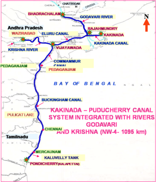
National Waterway 4 (NW-4) is a 1,095 kilometres (680 mi) long waterway in India. It has been declared as an Indian National Waterway and is currently under development. It connects the Indian states of Telangana, Andhra Pradesh, Tamil Nadu, and the union territory of Puducherry. The NW-4 runs along the Coromandal Coast through Kakinada, Eluru, Commanur, Buckingham Canals and also through part of Krishna and Godavari rivers in South India. It was declared a National Waterway on 24 November 2008 under the Provisions of National Waterways Bill, 2006. It is being developed by the Inland Waterways Authority of India (IWAI), and was scheduled for completion by 2013. The National Waterways Act, 2016 has extended the length of NW-4 from 1,095 km (680 mi) to 2,890 km (1,800 mi) by connecting the Krishna and Godavari Rivers. The Project would be undertaken in 3 phases with first phase beginning in October, 2017 and to be completed by June, 2019

The Polavaram Project is an under construction multi-purpose irrigation project on the Godavari River in the Eluru District and East Godavari District in Andhra Pradesh. The project has been accorded National project status by the Central Government of India. Its reservoir back water spreads up to the Dummugudem Anicut and approx 115 km on Sabari River side. Thus back water spreads into parts of Chhattisgarh and Odisha States. It gives major boost to tourism sector in Godavari Districts as the reservoir covers the famous Papikonda National Park, Polavaram hydro electric project (HEP) and National Waterway 4 are under construction on left side of the river. It is located 40 km to the upstream of Sir Arthur Cotton Barrage in Rajamahendravaram City and 25 km from Rajahmundry Airport.
Pedda Gollapalem is a village in Nidamarru hamlet, Kruthivennu mandal, located in Krishna district on the sea coast of Bay of Bengal, Andhra Pradesh, India.

The coastline of Andhra Pradesh is located on the southeastern coast of the Indian Peninsula in the Bay of Bengal and is part of the Northern Circars. With a length of 975 km, it has the second longest coastline in India after Gujarat. The coastal corridor boasts several ports, harbors, vast stretches of sandy beaches, wildlife and bird sanctuaries, as well as fresh water lakes and estuaries.

Pattiseema Lift Irrigation Project is a river interlinking project which connects Godavari River to Krishna River. This project has thereby become the first of such irrigation type projects in the country to be completed in time without any budget enhancements. It also holds a record in Limca Book of Records. The project was Inaugurated by the Chief Minister of Andhra Pradesh Nara Chandrababu Naidu in March 2016 while the project was completed in one year record of time.
Vykuntapuram Barrage is an Indian barrage and water storage project. It is under construction on Krishna River 23 kilometers upstream of existing Prakasam Barrage with FRL 25M. It is designed to store 10 TMC of flood water coming from the Vyra and Munneru rivers. The backwater of this dam will extend beyond Pokkunuru to the toe of Pulichintala dam. Andhra Pradesh Chief Minister Nara chandrababu Naidu laid the foundation stone for this project on 13 February 2019.