
The Krishna River is a river in the Deccan plateau and is the third-longest river in India, after the Ganges and Godavari. It is also the fourth-largest in terms of water inflows and river basin area in India, after the Ganges, Indus and Godavari. The river, also called Krishnaveni, it is 1,400 kilometres (870 mi) long and its length in Maharashtra is 282 kilometres. It is a major source of irrigation in the Indian states of Maharashtra, Karnataka, Telangana and Andhra Pradesh.

YSR Kadapa district is one of the twenty six districts in the Indian state of Andhra Pradesh. On 19 August 2005 nomenclature of “Cuddapah” has been changed as “Kadapa” by the Government of A.P. It was renamed as Y.S.R District during the year 2010, in honour of Y. S. Rajasekhara Reddy, commemorating the former chief minister of united Andhra Pradesh. It is also one of the eight districts in the Rayalaseema region. Kadapa is the administrative headquarters for this district.

Nagarjuna Sagar Dam is a masonry dam across the Krishna River at Nagarjuna Sagar which straddles the border between Nalgonda district in Telangana and Palnadu district in Andhra Pradesh. The dam provides irrigation water to the Nalgonda, Suryapet, Krishna, NTR, Bapatla, Eluru, Palnadu, Khammam, West Godavari, Guntur, and Prakasam districts along with electricity generation.
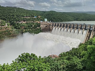
The Srisailam Dam is constructed across the Krishna River in Nagarkurnool district, Telangana and Nandyal district, Andhra Pradesh near Srisailam temple town and is the 2nd largest capacity working hydroelectric station in India.

The Gundlakamma River is a seasonal waterway that flows through the east-central part of the state of Andhra Pradesh, India. It arises in the Nallamala Hills, an offshoot of the Eastern Ghats. Its main headwaters lie some 6 kilometers from the village of Ardhaveedu, Prakasam district at an altitude of 425 m. above MSL. Numerous mountain streams join it as it descends down the thickly forested hills through a series of curves and tight bends. It follows a north-easterly direction and enters the plains near Cumbum, after flowing through a town named after it. Gundlakamma is the largest of all the rivers that originate from the Nallamalla Hills.
The Sangameswara temple is a Hindu temple in the Nandyal district, Andhra Pradesh, India. It is located near Muchumarri at the confluence of the Krishna and Bhavanasi rivers, in the foreshore of the Srisailam reservoir, where it is submerged for part of the time, surfacing when the water level recedes to a sufficient degree. It was first submerged after the Srisailam Dam was constructed in 1981, and first surfaced in 2003.

The Polavaram Project is an under construction multi-purpose irrigation project on the Godavari River in the Eluru District and East Godavari District in Andhra Pradesh. The project has been accorded National project status by the Central Government of India. Its reservoir back water spreads up to the Dummugudem Anicut and approx 115 km on Sabari River side. Thus back water spreads into parts of Chhattisgarh and Odisha States. It gives major boost to tourism sector in Godavari Districts as the reservoir covers the famous Papikonda National Park, Polavaram hydro electric project (HEP) and National Waterway 4 are under construction on left side of the river. It is located 40 km to the upstream of Sir Arthur Cotton Barrage in Rajamahendravaram City and 25 km from Rajahmundry Airport.
Mahatma Gandhi Kalwakurthy lift irrigation scheme (MGKLIS) is a lift irrigation project on River Krishna located in Mahbubnagar district in Telangana, India. The lift canal starts from the back waters of Srisailam Dam near Kollapur. The gravity driven, 100 kilometer canal provides cultivation for nearly 4,00,000 acres in 300 villages located in constituencies of Kollapur, Wanaparthy, Nagarkurnool, Kalwakurthy, Jadcherla and Achampet.
The Pulichintala Project is a multi-purpose water management project for irrigation, hydropower generation, and flood control in the state of Andhra Pradesh, India. It is a crucial irrigation facility for farmers in four coastal districts: West Godavari, Krishna, Guntur, and Prakasam, covering over 13 lakh acres. It has 24 gates and a balancing reservoir with a capacity of 46 Tmcft at 175 feet (53 m) MSL full reservoir level (FRL).
Alimineti Madhava Reddy Project earlier known as Srisailam Left Bank Canal is an irrigation project located in Nalgonda district in Telangana, India.

Galeru Nagari Sujala Sravanthi Project or GNSS project is an irrigation project in Kadapa and Chitoor districts of Andhra Pradesh.
Kosasthalaiyar River, also known as Kortalaiyar, is one of the three rivers that flow in the Chennai metropolitan area.
Handri-Neeva Sujala Sravanthi project is the longest water canal project in the region of Rayalaseema, Andhra Pradesh, India. The project was conceived to provide a reliable irrigation and drinking water supply for the region through drawing flood waters from the Srisailam reservoir.

R. Vidyasagar Rao Dindi Lift Irrigation Scheme is a lift irrigation project in Nalgonda, Telangana, India. It serves Nalgonda, Mahbubnagar and Khammam areas. It was named after R. Vidyasagar Rao, a foremost irrigation expert in Telangana.
Velugodu Reservoir is a balancing reservoir and located across the Galeru river, a tributary of Kundu River in Penner River basin, at Velugodu town in Nandyal district of Andhra Pradesh. This reservoir is part of Telugu Ganga project and mainly fed by gravity canal from back waters of Srisailam Dam through Pothireddypadu head / flow regulator located across the feeder canal. Velugodu Reservoir has gross storage capacity of 16.95Tmcft at 265 m MSL full reservoir level.

Kurnool Cuddappah Canal popularly known as K.C. Canal is an irrigation canal located in Kurnool and Kadapa districts in Andhra Pradesh, India.
Penna Ahobilam Balancing Reservoir(PABR) is an irrigation project located across Penna River in Anantapur district of Andhra Pradesh state in India. Anantapur city gets its drinking water from the PABR. The reservoir with live storage capacity of 305 million cubic metres is mainly fed by Tungabhadra high level canal originating from the Tungabhadra Dam to the extent of 10 Tmcft water. A 20 MW hydro electric power station is also constructed at the dam site.
Jeedipalli Reservoir is an irrigation project located in Anantapur district in Andhra Pradesh, India. It receives water from Handri-Neeva canal which draws water from Srisailam reservoir. It is located in Jeedipalli village of Beluguppa mandal.
Nagarjuna Sagar tail pond is a multipurpose reservoir located 21 km downstream from the Nagarjuna Sagar Dam across the Krishna River near Satrasala in Nalgonda district, India. Its gross water storage capacity is 6 Tmcft. The reservoir water spread area extends up to the toe of the Nagarjuna Sagar dam. The project was completed by July 2014.
The Veligonda Project is an irrigation project located in Markapur, Prakasam district in Andhra Pradesh, India. When completed, the project will provide irrigational facilities to 459,000 acres and drinking water to 1.5 million people in 29 Mandals of fluoride and drought affected areas in Prakasam district, Nellore district and Kadapa district by diverting 43.5 TMC of floodwater from the Krishna River from foreshore of Srisailam Reservoir near Kollamvagu and proposed to store in Nallamalasagar Reservoir. The water for the project is drawn through two 18.8 km long tunnels across Nallamala hills. The project has been renamed to the "Poola Subbaiah Irrigation Project". It displaces around 20,946 families. The oustees have protested for enhanced compensation over the years and many have not received the compensation promised to them.
