Cherupuzha (Kannur)

Last updated

Cherupuzha
Town
Cherupuzha 1.jpg
Cherupuzha Bridge
India Kerala location map.svg
Red pog.svg
Cherupuzha
Location in Kerala, India
India location map.svg
Red pog.svg
Cherupuzha
Cherupuzha (India)
Coordinates: 12°16′22″N75°22′02″E / 12.2728°N 75.3672°E / 12.2728; 75.3672 Coordinates: 12°16′22″N75°22′02″E / 12.2728°N 75.3672°E / 12.2728; 75.3672
CountryFlag of India.svg  India
State Kerala
District Kannur
Taluk Payyanur
Government
  Type Panchayati raj (India)
  Body Grama Panchayat
Area
[1]
  Total75.64 km2 (29.20 sq mi)
Elevation
[2]
46 m (151 ft)
Population
 (2011)
  Total30,733
  Density410/km2 (1,100/sq mi)
Languages
  Official Malayalam, English
Time zone UTC+5:30 (IST)
PIN
670511
Telephone code04985
ISO 3166 code IN-KL
Vehicle registration KL 86
Niyamasabha constituency Payyanur
Lok Sabha constituency Kasaragod
Nearest Railway station Payyanur
Website www.lsgkerala.in/cherupuzhapanchayat

Cherupuzha is a town in Kannur district, Kerala, India. It is the headquarters of the Cherupuzha Panchayat which is a special grade panchayat in Kerala. [3]

Contents

Location

It is located about 31 km east of taluk HQ Payyanur, 66 km north east of district HQ Kannur, 524 km from Capital city Thiruvananthapuram, 332 km away from Eranakulam, 150 km from Kozhikode, 121 km away from Mangalore and 326 km from Bangalore.

History

Cherupuzha and its surrounding areas was ruled by many royal dynasties in the past, including the Mooshika dynasty of Ezhimala, Chirakkal dynasty of Kolathunadu, Tipu Sultan of the Kingdom of Mysore, before it became a part of the British Raj. The original inhabitants of the area were primarily Hindus. Later on this region gained a sizable Christian and Muslim population. Now the place has Christians as majority. The economy was agrarian with strong feudal system - Janmi-Kudiyan system - permeating everyday life in past and in the present mainly small and medium farmers.

Geography

Cherupuzha is a hilly town (part of Western Ghats) on the eastern side of Kannur district. The terrain is undulating in nature and the extreme eastern side has forests bordering Karnataka state.

Tourism

Rajagiri Hills Rajagiri Hills, Kanhangad. (8).jpg
Rajagiri Hills
Kottathalachi Mount Near Cherupuzha Kottathalachi Mount.JPG
Kottathalachi Mount Near Cherupuzha

Surrounded by green terrains and mesmerizing hills, Tejaswini river in Cherupuzha offers adventurous tourist activity like white water rafting in Western ghats. Kollada near Cherupuzha is the starting point to kick off the rafting trip on the river. The rafting experience at Cherupuzha is an ideal stepping stone for those who aspires challenging high altitude rapids. Inflatable rafts are used here which is less expensive and easily maintained. [4] [5] White Water Rafting at Tejaswini river is one of the 17 best places for rafting in India. [6]

Demographics

As of 2011 Census, Cherupuzha Grama Panchayat had a population of 30,733 where 15,004 are males and 15,729 are females. There were 7,052 families residing in the panchayat limits. The sex ratio of Cherupuzha was 1,048 lower than state average of 1,084. In Cherupuzha, 9.7% of the population was under 6 years of age.

Average literacy rate of Cherupuzha was 95% higher than state average of 94%. Male literacy stands at 96.3% and Female literacy at 93.7%. [7]

Administration

Cherupuzha Grama Panchayat is a part of Payyanur Block Panchayat. Cherupuzha Panchayat is politically a part of Payyanur Assembly constituency in Kasaragod Loksabha constituency. [8] [9]

Connectivity

Cherupuzha Bus Station Cherupuzha 3.jpg
Cherupuzha Bus Station

Satellite towns that are nearby and places at a longer distance which has direct bus route from Cherupuzha includes Pulingome, Palavayal, Kozhichal, Thirumeni, Padiyotchal, Peringome, Chittarikkal, Vellarikundu, Panathur, Alakkode, Chemperi, Payyavoor, Iritty, Payyanur, Kanhangad, Taliparamba, Kannur, Kasaragod, Kozhikode, Mangalore, Bangalore, Ernakulam, Thrissur, Thodupuzha, Pala, Kottayam, Pathanamthitta etc. These population centres are well connected to Cherupuzha by road.

Water bodies

Tejaswini River, also called "kariankode puzha" in Malayalam, which is comparatively small among 44 rivers of Kerala, flows beside this town. It originates from Brahmagiri hills of Coorg forest in Karnataka, enters Kerala near Pulingome, flows through the districts of Kannur and Kasaragod and meets the Arabian Ocean, near Nileshwaram as a part of Valiyaparamba Backwaters. Tejaswini, which is 64 km long, do have a rafting stretch of 20 km with plenty of rapids extending up to class-3.

Places of worship

Transport

Air

The nearest airport (70 km) is at Mattanur and Mangalore, Calicut are not far away. All of them are international airports but direct flights are available only to Middle Eastern countries.

Rail

The nearest railway station is 34 km away Payyanur on Shoranur-Mangalore Section. Direct trains are available to Mumbai, Delhi, Bangalore, Mangalore, Ernakulam, Kozhikode, Thiruvananthapuram, Chennai and other parts of the country.

Roads

Kerala Hill Highway (SH 59) passes through Cherupuzha town connects it with Iritty and other towns in eastern areas of Kannur and Kasaragod districts. Mysore and Bangalore can be accessed on the eastern side of Iritty. [10]

The National Highway(NH 66) passes through Perumba junction through proposed Ezhimala - Bagamandalam Highway. Goa and Mumbai can be accessed on the northern side and Cochin and Thiruvananthapuram can be accessed on the southern side.

Two main roads are Cherupuzha-Payyanur and Cherupuzha - Alakode. All the other roads in this area were built by the people themselves. The roads, Cherupuzha-Pulingome – Kottathalachi, Edavaramba – Koombankunnu, Kariyakkara – Koombankunnu, Cherupuzha-Pulingome-Rajagiri, Rajagiri-Josegiri, Vazhakkundam – Churappadavu, Chunda – Vilakkuvettam and Umayanchal – Kottathalachi are examples of the collective effort of people of Cherupuzha and Pulingome.

Another important road in the area is Cherupuzha-Thirumeni- Muthuvom road which is of a length of 9 kilometers. From Thirumeni, one can reach to its outskirts like Chathamangalam, Thabore, Muthuvom and Korali. Both private and public transport buses are available from Cherupuzha to Kannur, Kozhikode, Cochin and Bangalore.

Proposed Ezhimala-Bengaluru road

A new bridge, for the proposed Ezhimala-Payyanur-Cherupuzha-Pulingome-Talakkaveri-Bhagamandala-Bengaluru road, has already been constructed over Pulingome river near Cherupuzha, connecting Kerala and Karnataka. Talks are on between Karnataka, Kerala and central Governments on this project. However, Karnataka was not willing to construct the road along the reserve forest and the project got stuck. If this road became a reality, the distance to Bangalore and Mysore would be reduced by more than 60 kilometers also 120 kilometers between Kannur and Bangalore. The road is strategically important for the northern part of the state because it connects two major institutions, the Indian Naval Academy in Ezhimala and the Central Reserve Police Force (CRPF) training centre in Peringome with Karnataka. [11]

Cherupuzha-Chittarikkal

This road stretching across Kerala, connecting Kannur and Kasaragod districts.

The development for bypass route from Cherupuzha traverses through Prapoyil, Thirumeni, Chathamangalam, Parappa, Karthikapuram Road is still underway, but very significant because it connects Cherupuzha to places like Karthikapuram, Parappa, Neduvode and Rayarome at the shortest distance. This is the only road that goes through the common meeting place of Cherupuzha, Alakode and Udayagiri panchayaths. Efforts are on to renovate the road completely and make it the bypass of Alakode-Therthaly-Cherupuzha Road. The advantage is in case of any complication on the major road, the bypass can be used.

Hanging Bridge

The major attraction in Cherupuzha is a hanging bridge in Tejaswini river (also known as karyamkode puzha) which connects both Kasaragod and Kannur districts.

Hospitals

Education

Navajyothi College, Kannikkalam Navajyothi College.jpg
Navajyothi College, Kannikkalam

See also

Related Research Articles

<span class="mw-page-title-main">Payyanur</span> Municipality in Kerala, India

Payyanur, IPA: [pɐjːɐn̺ːuːɾ], is a municipal town and a taluk, a sub-district administrative unit, in the Kannur district of Kerala, India. On 10 March 2018, Kerala Chief Minister Pinarayi Vijayan inaugurated Payyanur as the fifth taluk in the district. Payyanur taluk comprises 22 villages including 16 de-linked from the Taliparamba taluk and six from the Kannur taluk. The town is situated on the banks of the Perumba River.

Palavayal is a village in the eastern hilly areas of Kasaragod district in the Indian state of Kerala. Palavayal consists of small villages like Odakkolly, Chavaragiri and Malankadavu. Palavayal is separated from another town Pulingome which is in Kannur District.

<span class="mw-page-title-main">Valiyaparamba</span>

Valiyaparamba is a coastal island in Hosdurg taluk, Kasaragod district, Kerala state, India.

<span class="mw-page-title-main">Ulikkal</span> Town in Kerala, India

Ulikkal is a growing town in Kannur District in Kerala. It is the HQ of Ulikkal Grama Panchayat in Iritty Taluk. Kerala State Hill highway SH 59 passes through Ulikkal Town.

<span class="mw-page-title-main">Kavvayi Backwaters</span> Island in India

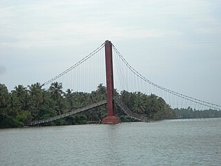
Kavvayi Backwaters located near Payyanur is the third largest backwater in Kerala and the largest one in north Kerala. The Kavvayi Kayal(Backwaters) is dotted with several small and large islands. Valiyaparamba island is the largest among them and stretches over 16 km2.

<span class="mw-page-title-main">Naduvil and Kudianmala</span> Town in Kerala, India

Naduvil is a small town in Kannur district in the Indian State of Kerala. The town is the headquarters of Naduvil Grama panchayat.

<span class="mw-page-title-main">Pulingome</span> Village in Kerala, India


Pulingome is a village in Kannur District of Kerala state, India.

<span class="mw-page-title-main">Alakode, Kannur district</span> Town in Kerala, India

Alakode is an emerging town in Kannur district in the Indian state of Kerala. It is located 46 km (29 mi) North of District headquarters Kannur. Alakode is located on Taliparamba-Manakadavu-Coorg Road. Alakode was one of the major centers of Malabar Migration.

<span class="mw-page-title-main">Ramanthali</span> Village in Kerala, India

Ramanthali is a village in Kannur district in the Indian state of Kerala. It boasts the gateway for Indian Naval Academy in Ezhiamala.

<span class="mw-page-title-main">Thirumeni</span> Village in Kerala, India

Thirumeni is a village in Kannur district in the Kerala state of India. It is known for its hill station Chathamangalam_Hills. The village has several recently migrated families from various parts of the erstwhile political entity (state) of Travancore who settled here in the famed "Malabar migration period" in the Nineteenth Century. Most of the inhabitants of the village reside in the valley of three major hills by name Chathamangalam Theruvamala alias Alumbumala, Kottathalachimala and Thevarkunnumala. Thirumeni is a small junction with a few government institutions, religious institutions and small shops in int. and is subdivided into smaller villages like Kokkadave, Prapoyil, Chathamangalam (Kannur), Thabore, Muthuvom, Korali, Chattivayal, Thannichal, Paruthikallu etc.

Manakadavu is a village in Taliparamba taluk of Kannur district in the Indian state of Kerala, near Karnataka Forest. It is about 56 km from Kannur city. Nearest bus station in Taliparamba at 36 km

Padiyotchal is a small town in Kannur district in the Indian state of Kerala.

<span class="mw-page-title-main">Kozhichal</span>

Kozhichal is a small hillside town in the north eastern region of the district of Kannur in the Kerala state. Kozhichal shares its boundaries with Kodagu district of Karnataka state towards the east, rest of the Kannur district towards west and south and the district of Kasaragod towards north.

<span class="mw-page-title-main">Thabore</span> Village in Kerala, India

Thabore is a hill top village in Kannur district in the Indian state of Kerala. Some parts of Thabore comes under Udayagiri, Kerala gram panchayat and the rest under Cherupuzha (Kannur) gram panchayat. Tourists come here to see the scenery of the hill station. A statue of Jesus Christ has been recently? installed on the hilltop which attracts a large number of tourists. Nearby places include Udayagiri, Thirumeni, Chathamangalam Hills and Kozhichal.

<span class="mw-page-title-main">Political divisions of Kannur district</span>

Kannur district is politically organized into a complex web of taluks, blocks, panchayaths and villages. In addition, there are also parliamentary divisions called Assembly constituencies and Lok Sabha constituencies.

<span class="mw-page-title-main">Transportation in Wayanad</span>

The district capital of Wayanad is Kalpetta town. Kalpetta has very good road connectivity with the rest of Kerala and neighboring South Indian cities. National Highway 766 (India) NH766 connects Kalpetta with Kozhikode and Mysore. State Highways connect Kalpetta with Ooty in Tamil Nadu and Madikeri in Karnataka.

Cherupuzha and its surrounding areas was ruled by many royal dynasties in the past, including the Mooshika dynasty of Ezhimala, Chirakkal dynasty of Kolathunadu, Tipu Sultan of the Kingdom of Mysore, before it became a part of the British Raj. The original inhabitants of the area were primarily Hindus. Later on this region gained a sizable Christian and Muslim population. The economy was agrarian with strong feudal system - Janmi-Kudiyan system - permeating everyday life.

<span class="mw-page-title-main">Transportation in Kannur district</span>

Kannur has a good road network connecting to Bangalore, Mangalore, Kodagu and Cochin. The railway station is also well connected to all parts of India. There is new International airport from Kannur opened on 9 December 2018, other nearest airports are at Calicut and Mangalore. Thalassery, Payyanur, Taliparamba and Iritty are the other transport hubs.

<span class="mw-page-title-main">Chathamangalam (Kannur)</span> Village in Kerala, India

Chathamangalam (ചാത്തമംഗലം), also known as Chathamangalam Hills, Kannur Theruvamala or just Theruvamala, is a hill station village and trekking spot in Kannur district, Kerala, India alongside the Coorg boarder of the neighbouring Karnataka state, which consists of a vast plain of green grasslands that made it earn the nickname Evergreen Chathamangalam. It is located in the border of Cherupuzha, Alakode and Udayagiri Grama Panchayats.

<span class="mw-page-title-main">Payyanur Taluk</span> Tehsil in Kerala, India

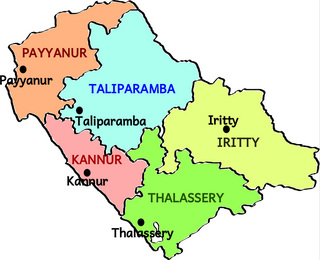
Payyanur Taluk comes under Taliparamba revenue division in Kannur district of Kerala, India. Payyanur is one of the 5 taluks in Kannur district established on March 2018 carved out from Taliparamba and Kannur taluks. Payyanur taluk comprises 22 villages including 16 delinked from Taliparamba taluk and 6 from Kannur taluk. It borders Kasaragod district in the north, Taliparamba and Kannur taluk in the south and Karnataka state in the east. Most of the government offices are in Payyanur Mini Civil Station. Payyanur taluk consists of Payyanur Municipality and 11 Panchayats.

References

  1. "കണ്ണൂര്‍ ജില്ലയിലെ ഗ്രാമ പഞ്ചായത്തുകളുടെ അടിസ്ഥാന വിവരങ്ങള്‍ | Deparyment of Panchayats".
  2. "cherupuzha elevation map". topographic-map.com.
  3. "DE Status".
  4. "White water rafting: A pleasant adventure on river Tejaswini". Malayala Manorama . Retrieved 18 August 2016.
  5. "Rafting on Tejaswini River, Kannur, Kerala, India".
  6. "17 Best Places For White Water Rafting In India". 22 February 2021. Retrieved 22 February 2021.
  7. Kerala, Directorate of Census Operations. District Census Handbook, Kannur (PDF). Thiruvananthapuram: Directorateof Census Operations,Kerala. p. 224,225. Retrieved 14 July 2020.
  8. "Niyamasabha constituencies of Kannur". ceo.kerala.gov.in.
  9. "Assembly Constituencies - Corresponding Districts and Parliamentary Constituencies" (PDF). Kerala. Election Commission of India. Archived from the original (PDF) on 4 March 2009. Retrieved 18 October 2008.
  10. "Hill Highway in Kerala; DPR ready for just 79 kms". Mathrubhumi . Retrieved 13 September 2016.
  11. "Inter-state road project faces green hurdles". Times of India .
  12. "List of degree colleges in Kannur-Kerala". vidyatime.com.
  13. "Higher Education Institutes in Kannur University".
  14. "Schoolist". www.dhsekerala.gov.in.