Thabore

Last updated

Thabore
village
Thabore Road Map.jpg
Route map
Coordinates: 12°15′0″N75°27′0″E / 12.25000°N 75.45000°E / 12.25000; 75.45000
Country India
State Kerala
District Kannur
Languages
  Official Malayalam, English
Time zone UTC+5:30 (IST)
PIN
670511
Telephone code04602
ISO 3166 code IN-KL
Vehicle registration KL 59
Literacy99%
Thabore Hills Thabore00.jpg
Thabore Hills
Scenery from Thabore Thabore02.jpg
Scenery from Thabore
St Josephs LP School Thabore St Josephs LP School Thabore.jpg
St Josephs LP School Thabore

Thabore is a hill top village in Kannur district in the Indian state of Kerala. Some parts of Thabore comes under Udayagiri, Kerala gram panchayat and the rest under Cherupuzha (Kannur) gram panchayat. Tourists come here to see the scenery of the hill station.[ citation needed ] A statue of Jesus Christ has been recently[ when? ]? installed on the hilltop which attracts a large number of tourists. Nearby places include Udayagiri, Thirumeni, Chathamangalam (Kannur) and Kozhichal.

Contents

The altitude is about 500 m above sea level. Temperature ranges from a minimum of 13 °C to a maximum of 28 °C. Warm clothes and rain gear is recommended in monsoon and winter seasons. People here are mostly Christians and Hindus. Most people are engaged in agriculture. This area exports hill products: rubber, dry copra, pepper, arecanut, etc. to industries in the northern part of India. It is a place where a huge number of people migrated during the 1940s and '50s from the Travancore area; now they play a major role in the local economy. The villagers are also politically interested. The main political parties are Communist Party of India (Marxist), Indian National Congress, Kerala Congress and BJP.

It is approximately 60 km from district center, Kannur town.

The nearest towns are cherupuzha and alakode which is 13 km away and udayagiri about 4 km away from thabore.

Migration from the south

The famine after World War II and the misrule of Sir. C. P. Ramaswamy Iyer incited a large scale migration of people from Travancore (South Kerala) to this area. The migration continued well into the 1970s and 1980s. [1] A vast majority of these migrants were Christians who had a completely different social and agricultural background. These hard working people brought new agricultural practices to this area. They introduced cash crops like rubber and daily staples like tapioca to the region.

The migrants also brought a new attitude to the region, one that challenged the established Janmi-Kudian feudal system. [2] The migrants bought large tracts of land outright from the Janmis and put down permanent crops heralding an era of prosperity for the area. The immigrants, despite their cultural and social difference, soon became an integral part of social fabric.

Early farming methods

Until the early 1950s, [3] this region used outdated agricultural practices and depended on the Indian monsoons for its irrigation needs. Agricultural land lay fallow after harvest. At the beginning of the next growing season, the bushes that cover the land would be cleared and the plant material burned to prepare the land for the next cycle of rice cultivation. This method, known as 'punam krishi' allowed people to grow staples like rice and black gram.

How to reach Thabore

Thabore is 60 km from Kannur and 44 km from Payyanur. Buses ply from Kannur via Alakode and Payyanur via Cherupuzha are available.

The national highway passes through Payyanur town. Goa and Mumbai can be accessed on the northern side and Cochin and Thiruvananthapuram can be accessed on the southern side. Taliparamba has a good bus station and buses are easily available to all parts of Kannur district. The road to the east of Iritty connects to Mysore and Bangalore. But buses to these cities are available only from Kannur, 22 km to the south. The nearest railway stations are Kannapuram and Kannur on Mangalore-Palakkad line. Trains are available to almost all parts of India subject to advance booking over the internet. There are airports at Kannur, Mangalore and Calicut. All of them are small international airports with direct flights available only to Middle Eastern countries.

Education

St.Joseph's L.P School is a day school for boys & girls, was established in 80's. It is an international institute especially devoted to the education of young kids.

This institution is open to girls and boys of all communities, irrespective of status, castes, creed and religion. lt imparts not only academic education to kids, but also helps them to form an integrated personality by developing in them a strong character, love of truth, respect loyalty a sense of justice and the necessity for honest, hard work. This will make them an honor for womanhood and a source of happiness and blessing to all with whom they come in contact.

Physical Training, Social, Cultural and other extracurricular activities are given adequate place in the children's education to make them disciplined and worthy citizens. Moral Education, taught to all children, aims at inculcating in them right values and attitudes.

St. Joseph’s Church

St. Joseph's Church [4] was established in 1974 by the Christians (the Syro-Malabar Church) who migrated from Travancore. The church in its present form was built in the nineties. This church comes under Cherupuzha forane, Syro-Malabar Catholic Archeparchy of Tellicherry. The Archdiocese of Tellicherry is an ecclesiastical province of the Syro-Malabar Church in Kerala, India. The Diocese of Tellicherry was erected on 31 December 1953 by the papal bull Ad Christi Ecclesiam regendam of Pope Pius XII, against the backdrop of large-scale migration of thousands of Syro-Malabar Catholics from South to the Northern forestlands of Kerala. The boundaries of the diocese were extended in 1955 to some districts in the states of Karnataka and Tamil Nadu, for the pastoral care of the migrants settled there. The diocese grew fast and became a stronghold of the Catholic Church in this region within a short period. The diocese was bifurcated in 1973, and the diocese of Mananthavady was erected. Again, the Diocese of Tellicherry was bifurcated twice, in 1986 to form the diocese of Thamarassery and in 1999 to form the diocese of Belthangady. The diocese was raised to the stature of metropolitan archdiocese by the papal bull Spirituali bono Christi fidelium of Pope John Paul II in 1995. Bishop Mar Sebastian Valloppilly was the first bishop of the Diocese of Tellicherry. The achdiocese enjoyed the gracious leadership of Archbishop Mar George Valiamattam from 1 May 1989 to 30 October 2014. On 30 October 2014 he resigned and Archbishop Mar George Njaralakatt was installed as the new Archbishop of Tellicherry. He assumed office on the same day.

Chathamangalam Hills

Chathamangalam Theruvamala Chathamangalam Theruvamala.jpg
Chathamangalam Theruvamala

Chathamangalam Hills is a hill station situated very close to Tabore and has its boundaries overlapping with the Munderithattu region, the border between Chathamangalam and Tabore. Chathamangalam-Cherimavu-Tabore road connects Thabore to the Chathamangalam hills also known as Theruvamala and Alumbumala. Protection of the region from land mafiya is important to the people of Tabore too. Earlier an action committee was formed at Thabore with the same intention.
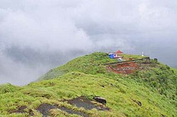
Kottathalachi Mount

Kottathalachi Mount Kottathalachi Mount.JPG
Kottathalachi Mount

Kottathalachi Mount [5] is a Christian pilgrim centre in north Kerala. It is located at around 2,500 feet above sea level. On Good Friday of 1958, the holy cross was installed at "Kottathalachi Mala" by Fr. Mathew Mannuramparambil. Since then the first Sunday after Easter is being celebrated here by thousands of pilgrims every year.

At present there is road facility until the middle of the mountain (Anakuzhi). One has to reach Pulingome, which is a small village town in Cherupuzha Panchayat, to take the shortest and easiest trip to Mount Kottathalachi.

Kottathalachi is known as the "Malayattoor of Malabar".

Related Research Articles

<span class="mw-page-title-main">Taliparamba</span> Municipality in Kerala, India

Taliparamba is a Municipality in Taliparamba taluk of Kannur district, Kerala, India. The municipal town spreads over an area of 18.96 square kilometres (7.32 sq mi) and is inhabited by 44,247 number of people.

<span class="mw-page-title-main">Peravoor</span> Town in Kerala, India

Peravoor is a town and Grama Panchayat in Kannur district of Kerala state in India. It is located 50 km (31 mi) east of Kannur and 40 km (25 mi) north east of Thalassery. And Iritty, the nearest municipality is 14 km (8.7 mi) north of Peravoor. Peravoor is situated in the Western Ghats mountain range.

<span class="mw-page-title-main">Syro-Malabar Catholic Archeparchy of Tellicherry</span> Eastern Catholic archeparchy in India

The Syro-Malabar Catholic Archeparchy of Thalassery is an archeparchy of the Syro-Malabar Church in communion with the See of Rome. The boundaries of the Thalassery ecclesiastical province were extended to include Mangalore, Chickmangalore, Mysore, Shimoga and Ootty as there were settlers in the neighbouring States. The diocese covers an area of 18,000 km² and a Catholic population of 273,826. Since 2022, Joseph Pamplany is the Metropolitan Archbishop.

<span class="mw-page-title-main">Naduvil and Kudianmala</span> Town in Kerala, India

Naduvil is a small town in Kannur district in the Indian State of Kerala. The town is the headquarters of Naduvil Grama panchayat.

<span class="mw-page-title-main">Pulingome</span> Village in Kerala, India


Pulingome is a village in Kannur District of Kerala state, India.

<span class="mw-page-title-main">Nadavayal</span> Village in Kerala, India

Nadavayal is a small village town near Panamaram in Wayanad district, Kerala, India. This small town hosted early migrants from Travancore (Thiruvithaamkoor).

<span class="mw-page-title-main">Cherupuzha, Kannur</span> Town in Kerala, India

Cherupuzha is a town in Kannur district, Kerala, India. It is the headquarters of the Cherupuzha Panchayat which is a special grade panchayat in Kerala.

<span class="mw-page-title-main">Chemperi</span> Town in Kerala, India

Chemperi is a town on the bank of the Chemperi River, in the Western Ghat, in the Kannur district of South India. Chemperi is often referred as the education city of Kannur with the establishment of Vimal Jyothi Engineering College, Chemperi. It is characterized by its production and export of rubber and spices, its beautiful hillocks, and its serene streams. Village and Panchayath of Chemperi is Eruvessi. Both Panchayath and Village offices of Eruvessi are located in Chemperi. Also Lourde Matha Forane Church, Chemperi is another attraction. Paithalmala and Palakkayam Thattu is also a few kilometres away.

<span class="mw-page-title-main">Alakode, Kannur district</span> Town in Kerala, India

Alakode is an emerging town and a panchayath in Kannur district in the Indian state of Kerala. It is located 46 km (29 mi) north of district headquarters Kannur. Alakode is located on Taliparamba-Manakadavu-Coorg Road. Alakode was one of the major centers of Malabar Migration.

<span class="mw-page-title-main">Kunhimangalam</span> Census Town in Kerala, India

Kunhimangalam is a census town situated in the northern coastal part of Kannur District in Kerala state on the outskirt of Payyanur. The population in 2011 was around 19,000 including Hindus, Christians and Muslim residents. The village lies in an agricultural region.

<span class="mw-page-title-main">Thirumeni</span> Village in Kerala, India

Thirumeni is a village in Kannur district in the Kerala state of India. It is known for its hill station Chathamangalam Hills. The village has several recently migrated families from various parts of the erstwhile political entity (state) of Travancore who settled here in the famed "Malabar migration period" in the nineteenth century. Most of the inhabitants of the village reside in the valley of three major hills by name Chathamangalam Theruvamala alias Alumbumala, Kottathalachimala and Thevarkunnumala. Thirumeni is a small junction with a few government institutions, religious institutions and small shops in int. and is subdivided into smaller villages like Kokkadave, Prapoyil, Chathamangalam (Kannur), Thabore, Muthuvom, Korali, Chattivayal, Thannichal, Paruthikallu etc.

Malabar Migration refers to the large-scale migration of Saint Thomas Christians who existed in Southern and Central Kerala for most of its history to Northern Kerala (Malabar) in the 20th century.

<span class="mw-page-title-main">North Malabar</span> Geographical / Historical Area in India

North Malabar refers to the geographic area of southwest India covering the state of Kerala's present day Kasaragod, Kannur, and Wayanad districts, and the taluks of Vatakara and Koyilandy in the Kozhikode District of Kerala and the entire Mahé Sub-Division of the Union Territory of Puducherry. Traditionally North Malabar has been defined as the northern portion of the erstwhile Malabar District which lies between Chandragiri River and Korapuzha River. The region between Netravathi River and Chandragiri River, which included the portions between Mangalore and Kasaragod, are also often included in the term North Malabar, as the Kumbla dynasty in the southernmost region of Tulu Nadu, had a mixed lineage of Malayali Nairs and Tuluva Brahmins.

<span class="mw-page-title-main">Udayagiri, Kerala</span> Village in Kerala, India

Udayagiri is a village in Taliparamba taluk of Kannur District in Kerala, India. It is about 55 km from Kannur city.

<span class="mw-page-title-main">Kozhichal</span>

Kozhichal is a small hillside town in the north eastern region of the district of Kannur in the Kerala state. Kozhichal shares its boundaries with Kodagu district of Karnataka state towards the east, rest of the Kannur district towards west and south and the district of Kasaragod towards north.

Kannur, India has a number of tourist attractions including beaches, hills, temples and other monuments.

<span class="mw-page-title-main">Political divisions of Kannur district</span>

Kannur district is politically organized into a complex web of taluks, blocks, panchayaths and villages. In addition, there are also parliamentary divisions called Assembly constituencies and Lok Sabha constituencies.

The following are places of worship in Cherupuzha:

Cherupuzha and its surrounding areas was ruled by many royal dynasties in the past, including the Mooshika dynasty of Ezhimala, Chirakkal dynasty of Kolathunadu, Tipu Sultan of the Kingdom of Mysore, before it became a part of the British Raj. The original inhabitants of the area were primarily Hindus. Later on this region gained a sizable Christian and Muslim population. The economy was agrarian with strong feudal system - Janmi-Kudiyan system - permeating everyday life.

<span class="mw-page-title-main">Chathamangalam (Kannur)</span> Village in Kerala, India

Chathamangalam (ചാത്തമംഗലം), also known as Chathamangalam Hills, Kannur Theruvamala or just Theruvamala, is a hill station village and trekking spot in Kannur district, Kerala, India alongside the Coorg border of the neighbouring Karnataka state, which consists of a vast plain of green grasslands that made it earn the nickname Evergreen Chathamangalam. It is located in the border of Cherupuzha, Alakode and Udayagiri Grama Panchayats.

References

  1. Kumbattu Varkey Josep. Migration and Economic Development of Kerala. Mittal Publications, 1988, First edition, p. 95.
  2. SREEDHARA MENON A. KERALACHARITHRAM. D C Books, First edition.
  3. K.S. MATHEW, MAHAVIR SINGH, JOY VERKEY. MIGRATION IN SOUTH INDIA. Shipra Publications, 2005, First edition.
  4. "St. Joseph's Church Thabore::Tellicherry Archeparchy:: Syro Malabar Church Parish".
  5. http://kottathalachimount.com. Archived 11 April 2018 at the Wayback Machine