Kasaragod is a municipal town and administrative headquarters of Kasaragod district in the state of Kerala, India. Established in 1966, Kasaragod was the first municipal town in the district. It is the northernmost district of Kerala and is also known as Sapta Bhasha Sangama Bhumi.
Kannur is one of the 14 districts along the west coast in the state of Kerala, India. The city of Kannur is the district headquarters and gives the district its name. The old name, Cannanore, is the anglicized form of the Malayalam name "Kannur". Kannur district is bounded by Kasaragod District to the north, Kozhikode district to the south, Mahé district to the southwest and Wayanad District to the southeast. To the east, the district is bounded by the Western Ghats, which forms the border with the state of Karnataka. The Arabian Sea lies to the west. Paithalmala is the highest point in Kannur District (1,372m). Enclosed within the southern part of the district is the Mahé district of the Union Territory of Puducherry. The district was established in 1957.

Iritty is a Municipality and a Taluk of Kannur district in Kerala State, India. The town is the main market place for the farmer communities in the surrounding regions. Iritty is known as The Coorg Valley in God's Own Country. Iritty is at a distance of 20 km (12 mi) from Kannur International Airport and one among five taluks in Kannur district. Iritty is one of the major towns lies between Coorg and Kannur international airport -Mattanur.
Nelliyalam is a panchayat town in The Nilgiris district in the Indian state of Tamil Nadu. As of 2011, the town had a population of 44,590.
O' Valley or Ouchterlony Valley is a Town Panchayat in the Gudalur Taluk of The Nilgiris district in the Indian state of Tamil Nadu. The name is a contraction of an older name after a James Ouchterlony, who established coffee plantations in the area. This panchayat area is located between Mudumalai National Park and New Amarambalam Reserved Forest and has several valleys, streams and water falls.

Kasaragod is one of the 14 districts in the southern Indian state of Kerala. Its northern border Thalappady is located just 9 km south to Ullal, which is the southernmost portion of the major port city Mangalore, on the southwestern Malabar coast of India.

Naduvil is a small town in Kannur district in the Indian State of Kerala. The town is the headquarters of Naduvil Grama panchayat.

Cherupuzha is a town in Kannur district, Kerala, India. It is the headquarters of the Cherupuzha Panchayat which is a special grade panchayat in Kerala.

Thirumeni is a village in Kannur district in the Kerala state of India. It is known for its hill station Chathamangalam Hills. The village has several recently migrated families from various parts of the erstwhile political entity (state) of Travancore who settled here in the famed "Malabar migration period" in the nineteenth century. Most of the inhabitants of the village reside in the valley of three major hills by name Chathamangalam Theruvamala alias Alumbumala, Kottathalachimala and Thevarkunnumala. Thirumeni is a small junction with a few government institutions, religious institutions and small shops in int. and is subdivided into smaller villages like Kokkadave, Prapoyil, Chathamangalam (Kannur), Thabore, Muthuvom, Korali, Chattivayal, Thannichal, Paruthikallu etc.
Maloth (also known as malom) is a village in Kasaragod district of the state of Kerala., Maloth is a village in Western Ghats. It is situated in the Balal Panchayath of Kasaragod District of Kerala. It is a part of the Kasaragod Parliament constituency. Earlier it was in the Hosdurg assembly constituency which is renamed as Kanhangad after the delimitation of assembly constituencies in 2011. It shares borders with the Karnataka forest. Nearest towns are Kanhangad, Cherupuzha, and Nileshwaram. One can reach Maloth through bus from Kanhangad or from Cherupuzha. Private as well as KSRTC buses playing between Kanhangad and Konnakkad passes through the village.
Malabar Migration refers to the large-scale migration of Saint Thomas Christians who existed in Southern and Central Kerala for most of its history to Northern Kerala (Malabar) in the 20th century.

North Malabar refers to the geographic area of southwest India covering the state of Kerala's present day Kasaragod, Kannur, and Wayanad districts, and the taluks of Vatakara and Koyilandy in the Kozhikode District of Kerala and the entire Mahé Sub-Division of the Union Territory of Puducherry. Traditionally North Malabar has been defined as the northern portion of the erstwhile Malabar District which lies between Chandragiri River and Korapuzha River. The region between Netravathi River and Chandragiri River, which included the portions between Mangalore and Kasaragod, are also often included in the term North Malabar, as the Kumbla dynasty in the southernmost region of Tulu Nadu, had a mixed lineage of Malayali Nairs and Tuluva Brahmins.
Gudalur taluk is a taluk of Nilgiris district of the Indian state of Tamil Nadu. The headquarters of the taluk is the town of Gudalur.
Pandalur taluk is a taluk of Nilgiris district of the Indian state of Tamil Nadu. The headquarters of the taluk is the town of Pandalur.

Kallody is a village in the Edavaka Grama panchayath of the Wayanad district, Kerala, India. This village falls under the Mananthavady Taluk. The Hill Highway (Kerala) SH-59 passes through this village town.

Vellarikund is a town and taluk headquarters in the Hill range of Kasaragod District in the state of Kerala. Vellarikundu is located between Odayanchal and Chittarikkal on Odayanchal-Cherupuzha Road.

Thabore is a hill top village in Kannur district in the Indian state of Kerala. Some parts of Thabore comes under Udayagiri, Kerala gram panchayat and the rest under Cherupuzha (Kannur) gram panchayat. Tourists come here to see the scenery of the hill station. A statue of Jesus Christ has been recently? installed on the hilltop which attracts a large number of tourists. Nearby places include Udayagiri, Thirumeni, Chathamangalam (Kannur) and Kozhichal.
Cherupuzha and its surrounding areas was ruled by many royal dynasties in the past, including the Mooshika dynasty of Ezhimala, Chirakkal dynasty of Kolathunadu, Tipu Sultan of the Kingdom of Mysore, before it became a part of the British Raj. The original inhabitants of the area were primarily Hindus. Later on this region gained a sizable Christian and Muslim population. The economy was agrarian with strong feudal system - Janmi-Kudiyan system - permeating everyday life.

Kannur has a good road network connecting to Bangalore, Mangalore, Kodagu and Cochin. The railway station is also well connected to all parts of India. There is new International airport from Kannur opened on 9 December 2018, other nearest airports are at Calicut and Mangalore. Thalassery, Payyanur, Taliparamba and Iritty are the other transport hubs.
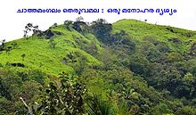
Chathamangalam (ചാത്തമംഗലം), also known as Chathamangalam Hills, Kannur Theruvamala or just Theruvamala, is a hill station village and trekking spot in Kannur district, Kerala, India alongside the Coorg border of the neighbouring Karnataka state, which consists of a vast plain of green grasslands that made it earn the nickname Evergreen Chathamangalam. It is located in the border of Cherupuzha, Alakode and Udayagiri Grama Panchayats.