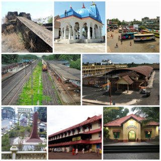
Kanhangad is a major town, located in the Kasaragod District, state of Kerala, India.

Brahmagiri, is a mountain range in the Western Ghats of south India. It is situated on the border between Kodagu district in Karnataka state in the north and Wayanad district of Kerala state on the south. Brahmagiri Hill, at 1608 m height, is a scenic tourist attraction. The top of Brahmagiri Hill is well forested and has much wildlife.

Uppala is a town and Headquarters of Manjeshwaram Taluk in Kasaragod district, Kerala, India. It is geographically located midway from Kasaragod to Mangalore. Easy geographical access and lack of major towns nearby are the key reasons for the town to develop exponentially, especially in the past decade. The population of Manjeshwaram Taluk alone was over 268,642 as of 2011. Uppala is 22 km north of Kasaragod and one of the fastest growing urban settlements in Kasaragod district. It is well known as an important trade hub in the northernmost part of Kerala state.

Kasaragod is one of the 14 districts in the southern Indian state of Kerala. Its northern border Thalappady is located just 9 km south to Ullal, which is the southernmost portion of the major port city Mangalore, on the southwestern Malabar coast of India.

Cherupuzha is a town in Kannur district, Kerala, India. It is the headquarters of the Cherupuzha Panchayat which is a special grade panchayat in Kerala.
Kuttikole is a village and Gram Panchayat in the Kasaragod district in the Indian state of Kerala.
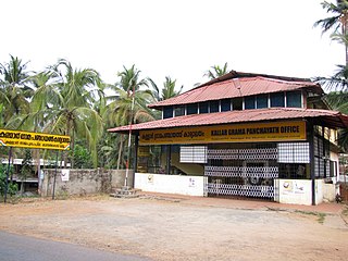
Balal is a village and a Grama Panchayat in Kasaragod district in the state of Kerala, India.

Bandadka is a small town in Kasaragod district in the state of Kerala, India. It is also called Kottakal because of Bandadka Fort. It comes under Kuttikole Grama Panchayat. It is located 38 km (24 mi) towards east from the District headquarters Kasaragod, 568 km (353 mi) away from the State capital Thiruvananthapuram, 5 km (3.1 mi) west of Karnataka border and 20 km (12 mi) away from Sullia. Bandadka's pin code is 671541 and it's postal head office is Chengala.
Karivedakam is a village in Kasaragod district in the state of Kerala, India.

Kodom is a village in Kasaragod district in the state of Kerala, India.
Maloth (also known as malom) is a village in Kasaragod district of the state of Kerala., Maloth is a village in Western Ghats. It is situated in the Balal Panchayath of Kasaragod District of Kerala. It is a part of the Kasaragod Parliament constituency. Earlier it was in the Hosdurg assembly constituency which is renamed as Kanhangad after the delimitation of assembly constituencies in 2011. It shares borders with the Karnataka forest. Nearest towns are Kanhangad, Cherupuzha, and Nileshwaram. One can reach Maloth through bus from Kanhangad or from Cherupuzha. Private as well as KSRTC buses playing between Kanhangad and Konnakkad passes through the village.
Munnad is a village in Kasaragod district in the state of Kerala, India.
Konnakkad is a hilly region in Maloth village of Kasaragod District in the state of Kerala. Konnakkad is Located in Kerala-Karnataka Border.

Vellarikund is a town and taluk headquarters in the Hill range of Kasaragod District in the state of Kerala. Vellarikundu is located between Odayanchal and Chittarikkal on Odayanchal-Cherupuzha Road.
Kakkachal is a place that comes under Bandadka village and Kuttikol panchayath in Kasaragod district of Kerala state, India.
Attenganam is a town in the Kasaragod District of the Indian state of Kerala. Primary road SH 56 connects Kanhangad and Panathur. The route has a limited bus service. Near by towns are Thattummal and Odayanchal

Panathur is a major town in Vellarikundu Taluk of Kasaragod district in Kerala State, India. It belongs to Kanhangad legislative constituency. Its population is about 12,000. It lies 1 km away from Kerala - Karnataka border, 42 km away from the nearest municipality, Kanhangad and 53 km away from the district headquarters, Kasaragod. It is surrounded from three sides by forest reserves and cashew plantations. Kudumbur River flows adjacent to the town.
Chavaragiri is a small rural village in Parappa Taluk in Kasaragod District of Kerala State, India. It comes under Palavayal Village in East Eleri Grama Panchayath. It is located 43 km towards East from Payyanur. The village is approximately 543 km from the State capital Thiruvananthapuram, Kerala.

Mulleria is a small town located in Karadka Panchayath, Kasaragod district in Kerala, India.
Kallar is a village in Kasaragod district in the Indian state of Kerala. Kallar is located on Kanhangad-Panathur road of 40 km south east of Kasaragod town and 27 km north east of Kanhangad.

