Vazhikkadavu

Last updated

Vazhikkadavu
village
Nadukaani Hill.jpg
Nadukani hill
Coordinates: 11°23′19″N76°20′47″E / 11.388663°N 76.346505°E / 11.388663; 76.346505
CountryFlag of India.svg  India
State Kerala
District Malappuram
Taluk Nilambur
Government
  Type Gram Panchayat
Area
  Total128.37 km2 (49.56 sq mi)
Elevation
489 m (1,604 ft)
Population
 (2011)
  Total47,322
  Density370/km2 (950/sq mi)
Languages
  Official Malayalam, English
Time zone UTC+5:30 (IST)
PIN
679333
STD code 04931
Vehicle registration KL-71

Vazhikkadavu is a village in Nilambur taluk of Malappuram district, Kerala, India. As of 2011, it has total population of 47,322. [1]

Contents

Geography

It is located on the CNG (Calicut-Nilambur-Gudalur) road 20 km north-east of Nilambur. Just after Vazhikkadavu town the ghat road known as Nadukani Churam starts through forests leading to Nadukani (20 km away) in Nilgiris district. The Kerala-Tamil Nadu border is at about 10 km from Vazhikkadavu. Its average elevation is 489 metres above the sea level. [2]

Climate

Vazhikkadavu has a Tropical Monsoon Climate (Am). On average, it gets the most rainfall in June, with 654 mm of precipitation; and the least rainfall in January, with 28 mm of precipitation.

Climate data for Vazhikkadavu
MonthJanFebMarAprMayJunJulAugSepOctNovDecYear
Mean daily maximum °C (°F)31.8
(89.2)
33.1
(91.6)
33
(91)
31.3
(88.3)
29.5
(85.1)
27
(81)
26.7
(80.1)
27
(81)
27.9
(82.2)
28.6
(83.5)
29.5
(85.1)
30.2
(86.4)
29.6
(85.4)
Daily mean °C (°F)25.2
(77.4)
26.4
(79.5)
27.1
(80.8)
26.5
(79.7)
25.5
(77.9)
24
(75)
23.8
(74.8)
23.9
(75.0)
24.2
(75.6)
24.5
(76.1)
24.6
(76.3)
24.3
(75.7)
25.0
(77.0)
Mean daily minimum °C (°F)18.4
(65.1)
19.6
(67.3)
21.2
(70.2)
22.2
(72.0)
22.3
(72.1)
21.9
(71.4)
21.6
(70.9)
21.5
(70.7)
21.1
(70.0)
20.7
(69.3)
19.7
(67.5)
18.3
(64.9)
20.7
(69.3)
Average rainfall mm (inches)28
(1.1)
29
(1.1)
95
(3.7)
232
(9.1)
371
(14.6)
654
(25.7)
599
(23.6)
445
(17.5)
291
(11.5)
425
(16.7)
269
(10.6)
77
(3.0)
3,515
(138.2)
Source: Climate-Data.org [3]

Demographics

Vazhikkadavu Town Vazhikkadav-bustand.jpg
Vazhikkadavu Town

According to the 2011 Indian Census, there are 9,972 households within Vazhikkadavu. Among the 47,322 residents, 22,470 are male and 24,853 are female. The literacy rate is 78.58%, with 18,004 of the male population and 19,182 of the female population being literate. The census location code is 627475. [1]

Services

Check posts of sales tax, forest, excise and motor vehicle departments are also present.

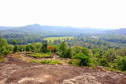
The Nadukani Ghat is famous for its greenery. It has rare species.

Places of worship

Masjids serve various parts of Vazhikkadavu including the ancient Marutha Juma Masjid.

The Karakkode Durga Devi Temple and Sri Ramananda Ashram are Hindu pilgrim sites in Nilambur area. The temple is under the management of Ramananda Ashram. H.H. Swami Sreedharananda is the founder of the ashram.

There are many churches including Christ the King Forane Church at Manimooly, St. Gregorios Orthodox Church at Mamamkara, St.Joseph Catholic Church at Narivalamunda, St.George Orthodox church at Modapoika,Assemblies of God church at Mamamkara,India Pentecostal Church of God church at Manimooly, St.Mary's Malankara Catholic church at Mamankara and Many other Evangelical Churches

Naxalite threat

In November, 2016, three Naxalites were killed near Karulai in an encounter with Kerala police. Naxalite leader Kappu Devaraj from Andhra Pradesh was one of those killed. [4] Naxalites visit the locality regularly to ask for food and shelter from the tribals. The police comb the area regularly, without making arrests. On 27 September 2016, Maoists and Kerala police fought in this area although no one was injured. [5]

Suburbs

Transport

Vazhikkadavu village connects to other parts of India through Nilambur town. State Highway No.28 starts from Nilambur and connects to Ooty, Mysore and Bangalore through Highways.12,29 and 181. National highway No.66 passes through Ramanattukara and the northern stretch connects to Goa and Mumbai. The southern stretch connects to Cochin and Trivandrum. State.

The nearest airport is at Karippor.

The nearest major railway station is at Nilambur.

Road

Vazhikkadavu is connected to major cities/towns in Kerala by road. Local buses reach Manjeri, Perinthalmanna, Kozhikode, Palakkad, Thrissur, Ernakulam, Kottayam, Thiruvananthapuram, etc. Inter-state buses reach Gudalur, Ooty, Mysore, Mandya, Hasan, Bangalore and Sulthan Bathery.

Tarred roads connect Vazhikkadavu to Karakkode,Puthirippadam, Vellakkatta, Poovathippoyil, Marutha (through Mamankara) and Nellikkuth (from Manimooli).

Rail

The nearest railway station is Nilambur Road railway station, which is 19 kilometres away

Air.

The nearest airport is Calicut International Airport, which is 60 kilometres away.

See also

Related Research Articles

<span class="mw-page-title-main">Nilambur</span> Place in Kerala, India

Nilambur is a major town, a municipality and a Taluk in the Malappuram district of the Indian state of Kerala. It is located close to the Nilgiris range of the Western Ghats on the banks of the Chaliyar River. This place is also known as 'Teak Town' because of the abundance of Nilambur teaks in this area; Which is a variety of a large, deciduous tree that occurs in mixed hardwood forests. Unlike many Municipalities of India; Nilambur is covered with large amounts of vegetation making it close to nature and hence make it very scenic and inspiring.

<span class="mw-page-title-main">Edakkara</span> Village in Kerala, India

Edakkara is a town located in Malappuram district of the Indian state of Kerala. It is an emerging commercial hub, and one of the busiest towns in Nilambur Taluk.

<span class="mw-page-title-main">Amarambalam</span> Village in Kerala, India

Amarambalam is a forest village near Nilambur town and conjoins Silent Valley National Park.the main town in amarambalam is pookkoottumpadam, pookottumpadam located in Malappuram district of the Indian state of Kerala. It is an emerging commercial hub, and one of the fastest growing towns in Nilambur Taluk.town area is 265.72 km2. Altitude rises sharply from 40 to 2,554 m.

<span class="mw-page-title-main">Mampad</span> Town in Kerala, India

Mampad is a town in Malappuram district, Kerala, India. located about 08 km east of Nilambur city. Nearby places include Edavanna, Areacode, Manjeri, Wandoor and Pandikkad. It is under the Wandoor Assembly Constituency. Kozhikode-Nilambur-Gudalur SH pass through here. The Mampad town is now developing day to day. Most people are engaged in agriculture and business activities. Hindus, Christians and Muslims co-exist in harmony adding to the diversity in faith and religion. The land is famous for football. The land where Asif Zahir Mampad Rahman played. He contributed a lot to the Malappuram district.

Marutha is a town in Nilambur taluk of Malappuram district. It is also known as village of Gold Hills. The tree Arjuna is also known as tree of "Marutha" and the place Lord Shiva appears as lingam under this Martha tree.

<span class="mw-page-title-main">Kaniyambetta</span> Village in Kerala, India

Kaniyambetta or Pachilakkad is a village in the Wayanad district of Kerala state, southern India. It is about 8 km from the district capital Kalpetta.

Cheekkode is a village in Malappuram district in the state of Kerala, India.

<span class="mw-page-title-main">Kottathara</span> Village in Kerala, India

Kottathara or Venniyode is a gram panchayat of Wayanad district, Kerala State, India.

Anjukunnu is a village in Wayanad district in the state of Kerala, India.

Noolpuzha is a village near Sulthan bathery in Wayanad district in the state of Kerala, India.

<span class="mw-page-title-main">Thrissilery</span> Village in Kerala, India

Thrissilery is a village in Wayanad district in the state of Kerala, India.

<span class="mw-page-title-main">Pothukal</span> Town in Kerala, India

Pothukallu (Pothukal) is located between Palunda and Munderi. Pothukallu is well known for its greenery, hospitality of the natives, and availability of all basic amenities, including schools, hospitals, shopping centers etc. There is a police station,forest station, mosque, church, and temple at nearby locations. Pothukallu is located at the boundary of three districts namely, Wayanad and Malappuram of Kerala state and The Nilgiris of Tamil Nadu.

<span class="mw-page-title-main">Areekode</span> Town in Kerala, India

Areekode is a town on the banks of the Chaliyar River in Areekode Grama Panchayat in Malappuram district, India. It was part of the Malabar district in British India.

<span class="mw-page-title-main">Chungathara</span> Village in Kerala, India

Chungathara is a village panchayat in Nilambur Taluk in Malappuram district, Kerala, India. It is one of the smallest gramapnachayat in Kerala. It is surrounded by Western Ghats.

<span class="mw-page-title-main">Cherukavu</span> Census town in Kerala, India

Cherukavu is a census town in Malappuram district in the state of Kerala, India.

<span class="mw-page-title-main">Puttamanna</span> Village in Kerala, India

Puttamanna is a village in Kalikavu Panchayat, Nilambur taluk in Malappuram district in the state of Kerala.. It is situated 31 kilometres from Manjeri 36 kilometres from Perintalmanna and 9 kilometres each from Karuvarakundu and Tuvvur. A stream flows through the village, which is a tributary of the Chaliyar.

Anchachavadi is a village beside Madumala in Kalikavu Panchayat, Nilambur taluk in Malappuram district in the state of Kerala. There is a school named GHS Anchachavadi

<span class="mw-page-title-main">Transportation in Wayanad</span>

The district capital of Wayanad is Kalpetta town. Kalpetta has very good road connectivity with the rest of Kerala and neighboring South Indian cities. National Highway 766 (India) NH766 connects Kalpetta with Kozhikode and Mysore. State Highways connect Kalpetta with Ooty in Tamil Nadu and Madikeri in Karnataka.

<span class="mw-page-title-main">Chettappalam, Wayanad</span> Place in Kerala, India

Chettappalam is a small village on Mysore Road between Mananthavady and Kattikkulam in Wayanad district, Kerala state, India.

<span class="mw-page-title-main">Kayakkunn</span> Village in Kerala, India

Kayakkunnu is a village near Nadavayal, Mananthavady in the Wayanad District of Kerala, India. The village is part of the Panamaram Panchayath, and the assembly constituency is Mananthavady. It is an agricultural area and its main crops include rice, coffee, pepper, ginger, cardamom, vanilla, rubber, areca nut, and coconut. The nearest towns are Nadavayal and Panamaram. Kayakkunn is situated midway along the Mananthavady–Gudalur interstate road.

References

  1. 1 2 "Basic Population Figures of India, States, Districts, Sub-District and Village, 2011". censusindia.gov.in. Archived from the original on 2 March 2023. Retrieved 18 April 2023.
  2. "Vazhikkadavu topographic map, elevation, terrain". Topographic maps. Retrieved 18 April 2023.
  3. "Vazhikkadavu climate: Temperature Vazhikkadavu & Weather By Month - Climate-Data.org". en.climate-data.org. Retrieved 18 April 2023.
  4. "നിലമ്പൂര്‍ ഏറ്റുമുട്ടല്‍: കൊല്ലപ്പെട്ടവരില്‍ മാവോവാദി നേതാവും".
  5. "മുണ്ടക്കടവില്‍ ആദ്യവെടി ഞങ്ങളുടേത് തന്നെയെന്ന് മാവോവാദികള്‍".