Related Research Articles

Ooty, officially known as Udagamandalam, is a town and a municipality in the Niligiris District of the Indian state of Tamil Nadu. It is located 86 km north of Coimbatore and 128 km south of Mysore and is the headquarters of the Nilgiris district. It is a popular hill station located in the Nilgiri Hills. Local Residents call it Blue Hills.

The Nilgiris District is in the southern Indian state of Tamil Nadu. Nilgiri is the name given to a range of mountains spread across the borders among the states of Tamil Nadu, Karnataka and Kerala. All types of single use plastics are banned in Nilgiris District. The Nilgiri Hills are part of a larger mountain chain known as the Western Ghats. Their highest point is the mountain of Doddabetta, height 2,637 m. The district is contained mainly within the Nilgiri Mountains range. The administrative headquarters is located at Ooty.

Coonoor is a Taluk and a municipality of the Nilgiris district in the Indian State of Tamil Nadu. As of 2011, the town had a population of 45,494.

Gudalur is a municipality and taluk in Nilgiris district in the Indian state of Tamil Nadu. Gudalur is one of the major towns in West TamilNadu and is located at 52 km from Ooty in the hilly terrain of The Nilgiris district. It is situated at the junction of Tamil Nadu, Kerala and Karnataka. Gudalur is derived from Tamil words "koodal" and "ooru" (village). Tea plantations dot the whole region, and the regional economy is heavily dependent on the tea industry.This land was an offspring to the exploration done by the British during the pre-independence period to cultivate tea plantation. Being a satellite town between Ooty and Mysore, both tourist spots, Gudalur has the prospect of developing into another tourist destination. Gudalur is a place where one can see people from the three states of Tamil Nadu, Kerala, and Karnataka live together cordially. According to Wikipedia, Gudalur Municipality is 1st largest of Gudalur Taluk and Division, 2nd largest of Nilagiri District and 17th largest of Kongu Nadu region and 117th Largest Municipal Town of Tamil Nadu.
Many Ghat Roads can be found in the Nilgiris District of Tamil Nadu, Southern India. Nearly all of the district is located in the Nilgiri Hills, part of the Western Ghats mountains. This area borders the states of Karnataka and Kerala. The hills consequently can be reached by road from three states. Most of these Ghat Roads go through heavily forested mountains and contain a number of sharp hair-pin bends.
The Nilgiri Mountains form part of the Western Ghats in western Tamil Nadu of Southern India. At least 24 of the Nilgiri Mountains' peaks are above 2,000 metres (6,600 ft), the highest peak being Doddabetta, at 2,637 metres (8,652 ft).

Catherine Falls is a double-cascaded waterfall located in Kotagiri, The Nilgiris District, Tamil nadu and it is also a major tourist spot in Kotagiri, located on the Mettupalayam road branching off at Aravenu. The upper fall drops to the floor, and is the second highest in the Nilgiri mountains. The waters from the upper stream of the Kallar river are crossed by the invisible Mettupalyam-Ooty road beyond the mountains in the south-west. The height of water falls is about 250 ft.Catherine Falls is named after the wife of M.D. Cockburn, believed to have introduced the coffee plantation to Kotagiri. The native name of the Catherine Falls is Geddhehaada Halla, meaning "Foothills Dale River". It can clearly been seen from the top of Dolphin's Nose if seeing the entire waterfall as one total impression is what you are looking for. It is also possible to take a road to the top of the falls.

Pykara is the name of a village and river 19 kilometres (12 mi) from Ooty in the Indian State of Tamil Nadu. The Pykara River is considered very sacred by the Todas. It rises at Mukurthi peak, flows northwards, and then turns to the west after reaching the edge of the plateau. The river flows through Murkurti, Pykara and Glenmorgan dams, and forms part of an important hydro-electric power project.
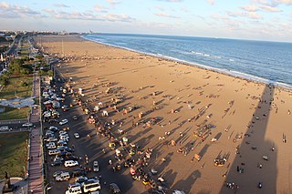
Tamil Nadu is a state in the south-eastern part of the Indian Peninsula. Tamil Nadu is previously a part of the United Madras Province, which was later partitioned based on languages. Tamil Nadu has more than 4,000 years of continuous cultural history. Tamil Nadu has some of the most remarkable temple architecture in the country, and a living tradition of music, dance, folk arts and fine arts. Tamil Nadu is well renowned for its temple towns and heritage sites, hill stations, waterfalls, national parks, local cuisine and the natural environment and wildlife. The state has the largest tourism industry in India with an annual growth rate of 16%. In 2015, the number of domestic arrivals was at 333.5 million making the state the most popular tourist destination in the country, and foreign arrivals numbered 4.68 million, the highest in the country, making it the most popular state for tourism in the country.

Southwick is a suburb in Ooty town. It is located on the NH 67 road from Ooty to Coonoor at about 3 km from the bus stand in Ooty. The suburb falls within the Ooty municipality in Tamil Nadu, India. It has derived its name from the Southwick Bungalow in the suburb.

Sigur Plateau is a plateau in the north and east of Nilgiri District in the Nilgiri Hills of Tamil Nadu, South India. It covers the 778.8 square kilometres (300.7 sq mi) portion of the Moyar River drainage basin on the northern slopes of the Nilgiri Hills, south of the Moyar River.

St. Stephen's Church is located on the road to Mysore in Ooty, in the state of Tamil Nadu, India. It is one of the oldest churches in the Nilgiris district.
Charring cross is a junction in National Highway 67 (India) intersecting the commercial road and the Ooty-Coonoor road in Ooty, Tamil Nadu. It is considered to be one of the most important and beautiful places in Ooty.The important landmark in charring cross is the Gandhi Statue.
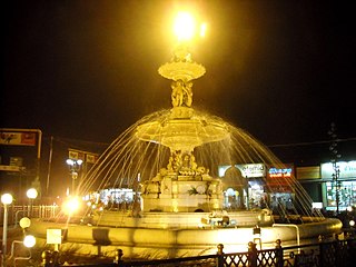
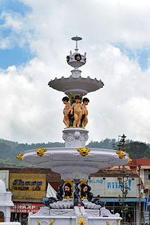
Adam's fountain is a public display fountain in Charring cross, Ooty. It was built in 1886 as a memorial to a Governor of Ooty, who was very famous in the region during his tenure. The total cost of finishing the fountain was between Rs. 13,000 to Rs. 14000, which was funded through public funding.
Valley View is a tourist spot in Ooty, India. It is located on the Ooty Coonoor road at a distance of 4 kilometres (2.5 mi) from Ooty bus stand and constitutes ward number 5 of the Nilgiris Lok Sabha constituency. It has views over the Ketti valley, and is an important tourist centre in Ooty. Ketti valley is sometimes referred to as the Switzerland of Southern India. The valley extends from the Mysore plateau to the Coimbatore plains and is one of the largest valleys in the world.
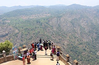
Dolphin's Nose Viewpoint is a tourist spot in Coonoor, The Nilgiris District, Tamil Nadu. Dolphin's Nose is well over 1,550 Meter above sea level, 10 km from Coonoor and is a spectacular spot to visit. The tip of the peak resembles a dolphin's nose, hence the name Dolphin's Nose. It is an enormous rock formation that is entirely unique. There are gigantic ravines found both to the left and right of Dolphin's Nose and there is a view of inspiring Catherine Falls with its continuing stream several thousand metres below which is located a relatively short distance away opposite of the Dolphin's Nose. Best part of spot are the hairpin turns and tea plantations on the way

Ooty Bus Stand, also known as Udhagamandalam Central Bus Stand is a bus station located in the town of Ooty. It serves as main bus stand for The Nilgiris district, Tamil Nadu, apart from bus stands in Coonoor, Kotagiri and Gudalur.
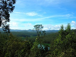
Emerald Lake is located near Emerald village in the Nilgiris district in Tamil Nadu. It is located in a region called the silent valley, about 25 kilometers from the Ooty town.

The Ooty Municipal Market is located in the Nilgiris district in Tamil Nadu. It is one of the largest retail markets in India. This market is the most important shopping centre in Ooty and utilized by the people for shopping vegetables, fruits and groceries.

Tirupattur is a town and also the headquarter of Tirupattur district, India, one of the oldest places in Tamil Nadu. It is known for its reservoir of fine sandal wood in the trailing mountains around it. It is located about 89 km from Vellore, 85 km from Hosur and Thiruvannamalai, 210 km from Chennai, and 125 km from Bangalore.
References
- ↑ "OOTY / UDHAGAI / UDHAGAMANDALAM / OOTACAMUND". nilgiris.tn.gov.in. Archived from the original on 14 January 2011. Retrieved 23 September 2011.
- ↑ "Amazing Kalhatty Waterfalls". tamilnadutourism.org. Retrieved 23 September 2011.
- ↑ "Kalhatty water falls". ooty.ind.in. Retrieved 23 September 2011.
- ↑ "Kalhatty water falls". smartcabs.org. Archived from the original on 27 August 2011. Retrieved 23 September 2011.
- ↑ "Kalhatty water falls". amudhasurabi.com. Retrieved 23 September 2011.
- ↑ "Kalhatty water falls". tamilnadu.com. Archived from the original on 13 November 2011. Retrieved 23 September 2011.
- ↑ "Amazing Kalhatty Waterfalls". photography-edu.com. Retrieved 23 September 2011.
Tourism in The Nilgiris | ||
|---|---|---|
Gardens and parks  |  | |
Viewpoint  | ||
Lake and waterfalls  | ||
Other tourist spots  | ||
Events  | ||
| This article related to a location in The Nilgiris District, Tamil Nadu, India is a stub. You can help Wikipedia by expanding it. |
| This waterfall-related article is a stub. You can help Wikipedia by expanding it. |