
Erode District is one of the 38 districts in the state of Tamil Nadu in India. It was the largest district by area in the state before the formation of Tirupur District in 2009. The headquarters of the district is Erode. It is divided into two revenue divisions, Erode and Gobichettipalayam, and is further subdivided into 10 taluks. Erode District was a part of Coimbatore District before its division into two on 17 September 1979. It covers an area of 5,722 square kilometres (2,209 sq mi), and as of 2011, had a population of 2,251,744.

Thiruvaiyaru is a panchayat town in Thanjavur District in the Indian state of Tamil Nadu.

Porur is a neighbourhood of Chennai, India. It is situated in the Maduravoyal taluk of Chennai district in the southern part of the city. Since 2011, it has been a part of the Chennai Corporation and included in zone number 11.

Coimbatore district is one of the 38 districts in the state of Tamil Nadu in India. Coimbatore is the administrative headquarters of the district. It is one of the most industrialized districts and a major textile, industrial, commercial, educational, information technology, healthcare and manufacturing hub of Tamil Nadu. The region is bounded by Tiruppur district in the east, Nilgiris district in the north, Erode district in the northeast, Palakkad district, Idukki district and small parts of Thrissur district and Ernakulam district of neighboring state of Kerala in the west and south respectively. As of 2011, Coimbatore district had a population of 3,458,045 with a sex ratio of 1,000 and literacy rate of 84%.

Karikala often referred to as Karikala the Great was a Tamil Emperor of the Early Cholas of the Chola dynasty who ruled ancient Tamilakam from Uraiyur. He is credited with the construction of the flood banks of the river Kaveri and conquest of Tamilakam, Andhra and Sri Lanka. He is recognised as the greatest of the Early Cholas. In Thiruvalangadu plates of Rajendra Chola I, Medieval Tamil Cholas listed Karikala Chola as one of their ancestors.

Dharapuram is a town situated along the banks of Amaravati River in Tiruppur district in the Indian state of Tamil Nadu. Dharapuram is one of the oldest towns in South India and was the capital of Kongu Nadu under the Cheras, Western Ganga Dynasty and later Kongu Cholas, at which time it was known as Viradapuram. Amaravathi River flows through the town. As of 2011, the town had a population of 67,007. The city houses famous temples including Agatheeswarar Temple, Kaadu Hanumanthasamy temple and many others.

Needamangalam (Nidamangalam) formerly Yamunambalpuram, is a town panchayat in Thiruvarur district in the Cauvery Delta of Indian state of Tamil Nadu. Needamangalam was originally part of the composite Tanjore Dist during British Raj until 1997 AD. In the 18th and 19th century, it was also called Yamunambalpuram. Needamangalam is the headquarters of the Needamangalam Taluk. The town is located 20 km east of Thanjavur, 80 km east of Tiruchirappalli and 318 km south of Chennai. Needamangalam is a junction for two busy highways, (i) National Highway 67 is a National Highway in Southern Indian states of Tamil Nadu and Karnataka that runs from Nagapattinam, a sea-side town in Tamil Nadu to Gundlupet, Karnataka (ii) State Highway SH-66 connecting Kumbakonam with Adirampattinam via Mannargudi in Cauvery Delta.

Sulur is a town located in the Coimbatore district of Tamil Nadu, India. It is a suburb of Coimbatore. It is the headquarters of Sulur Taluk of Coimbatore district. There are many market places and many big retail and wholesale shops are available and also taluk office, police station, and a famous RVS institutions consisting of medical college, arts college is there in Sulur. And also two big famous temples are there. It is also a taluk and legislative constituency which comes under the Coimbatore parliamentary constituency.
Thiruvidaimarudur is a panchayat town in Thanjavur district, in the Indian state of Tamil Nadu. The town is notable for its Mahalingeshwarar Temple, a Hindu shrine for Lord Shiva.
Thondamuthur is a suburb of Coimbatore city in the Indian state of Tamil Nadu. It comes under the Coimbatore Corporation. Thondamuthur is located 15 km west from the District headquarters Coimbatore, there are three routes available to reach Thondamuthur, through Vadavalli (15 km), through Perur (15 km), through Gandhi park, Vedapatti (14 km). Thondamuthur is the residential area. There is very high rise in population due to the development of many residential plots, apartments and many people reside here because the place is well connected with city centre through many routes and they can easily commute daily from Thondamuthur. The climate of Thondamuthur is very pleasant, low pollution, and many tourist spots like kovai Kutralam, Velliangiri hills, Isha Foundation, Siruvani hills, Vaidehi falls are situated near Thondamuthur. People can taste World's second tastiest water Siruvani here.
Vedapatti is a suburb of Coimbatore in the Indian state of Tamil Nadu. It is the western suburb of Coimbatore, which was included with the Coimbatore Corporation limits in 2011.

Vellalore is a panchayat town in Coimbatore district in the Indian state of Tamil Nadu. It is a southern suburb of the city. It is at 12 km east of Townhall, the centre of the city Coimbatore. It is situated on the southern bank of Noyyal river.

Perur Pateeswarar Temple is a Hindu temple dedicated to Lord Shiva located at Perur, in western part of Coimbatore in state of Tamil Nadu in India. The temple was built by Karikala Chola in 2nd century CE. The temple is located on the bank of the Noyyal River and has been patronized by poets like Arunagirinathar and Kachiappa Munivar. Lord Shiva, known as ‘Patteeswarar’, is the presiding deity of this temple together with his consort Parvati, who is known as ‘Pachainayaki’. The deity is believed to be Swayambu Lingam.
Nilakandaeshwarar Temple was constructed by Karikala Chola in 433 AD near Noyyal river in Irugur, Coimbatore, Tamil Nadu, India. The temple's main god was Shiva, along with Nanthi and Parvati.
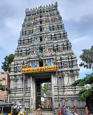
Arulmigu Koniamman Temple, is a historic Hindu temple located on the northern bank of the Noyyal River of Coimbatore, Tamil Nadu, India. It is dedicated to the goddess Koniamman, a form of Parvati. The temple is at the center of the city of Coimbatore in the core of the city, Town Hall, Coimbatore, Tamil Nadu, India. Koniamman is the "Guardian Deity" of the city. This temple is one of the twin historic temples in the city, the other being Perur Pateeswarar Temple.

Tiruppur or Tirupur ( ), is a city in the Indian state of Tamil Nadu. It is located on the banks of the Noyyal river and is the fourth largest urban agglomeration in Tamil Nadu. It is the administrative capital of Tiruppur district and is administered by the Tiruppur Municipal Corporation which was established in 2008.
Booluvampatti is a small village in Thondamuthur City located in south Taluka of Coimbatore district in Tamil Nadu, in India. It is 29.9 km from Coimbatore and 74.9 km from Palakkad. This village is near the forest boundary and its farm land often gets raided by wild elephants.
Singanallur is a major residential locality of the city of Coimbatore in Tamil Nadu, India. It is located on the banks of Noyyal river, which runs to the southern boundary of the locality. It is situated in the eastern part of the city, and is a major hub for the inter-city bus services towards Southern and Central districts of Tamilnadu from the city. It is one of the well developed neighborhoods in the city and has been part of Coimbatore Corporation since 1981. The East Zone Office of Coimbatore City Municipal Corporation is located at Singanallur.
Selvapuram is a major residential locality of the city of Coimbatore in Tamil Nadu, India. It is located on the banks of Noyyal river, which runs to the northwestern boundary of the locality. It is situated in the northwestern part of the city, and is a major residential and industrial locality in the city. It is one of the well developed neighborhoods in the city and has been part of Coimbatore Corporation since 1866.

