
Palakkad is one of the 14 districts in the Indian state of Kerala. It was carved out of the southeastern region of the former Malabar District on 1 January 1957. It is located at the central region of Kerala and is the second largest district in the state after Idukki. The city of Palakkad is the district headquarters. Palakkad is bordered on the northwest by the Malappuram district, on the southwest by the Thrissur district, on the northeast by Nilgiris district, and on the east by Coimbatore district of Tamil Nadu. The district is nicknamed "The granary of Kerala". Palakkad is the gateway to Kerala due to the presence of the Palakkad Gap, in the Western Ghats. The 2,383 m high Anginda peak, which is situated in the border of Palakkad district, Nilgiris district, and Malappuram district, in Silent Valley National Park, is the highest point of elevation in Palakkad district. Palakkad city is about 347 kilometres (216 mi) northeast of the state capital, Thiruvananthapuram.

Walayar is a border town, located in the eastern corner of Palakkad district in Kerala, India.

Palakkad, also known as Palghat, historically known as Palakkattussery, is a city and municipality in the Indian state of Kerala. It is the administrative headquarters of Palakkad District. Palakkad is the most densely populated municipality and the fourth-most densely populated city in the state. It was established before Indian independence under British rule and known by the name Palghat. Palakkad is famous for the ancient Palakkad Fort, which is in the heart of the city and was captured and rebuilt by Hyder Ali in 1766 which later fell into the hands of Zamorin in 1784. The city is about 347 kilometres (216 mi) northeast of the state capital, Thiruvananthapuram.
Karumathampatti is a Municipality in the Coimbatore district in the state of Tamil Nadu, India. It is one of the prominent developing suburb in Coimbatore metropolitan area, about 25 km away from the city centre. It is situated in between NH544 which connects the city of Coimbatore with Salem – Erode – Tirupur and also in between the State Highway 165 connects Annur – Kamanaikenpalayam. Nearby places are Somanur-3 km, Avinashi-10 km, Tirupur-20 km, Sulur-15 km, Annur-16 km. Coimbatore -27,Mettupalayam-38,Palladam-19. Karumathampatti lies near the junction of two major roads, NH544(Coimbatore – Salem) and Karumathampatti – Annur road.
Mallur is a village or town council (panchayat) in the Salem district, which is located in the Indian state of Tamil Nadu.

Vellalore is a panchayat town in Coimbatore district in the Indian state of Tamil Nadu. It is a southern suburb of the city. It is at 12 km east of Townhall, the centre of the city Coimbatore. It is situated on the southern bank of Noyyal river.
Vellarada is a border village situated in Thiruvananthapuram district in the state of Kerala, India. It is 42 km from Thiruvananthapuram. It is the southernmost part of Kerala state, sharing its border with Tamil Nadu. Vellarada is said to be the threshold to the high-range areas of the eastern part of Thiruvananthapuram district. The southernmost point of Western Ghats in Kerala is near Vellarada.

Kannur railway station (station code: CAN) is an NSG–2 category Indian railway station in Palakkad railway division of Southern Railway zone. It is the largest railway station serving the City of Kannur in Kerala. It lies in the Shoranur–Mangalore section of the Southern Railway zone. It is the largest railway station in terms of area and number of tracks in North Malabar region. At ₹62 crore in financial year 2018–19, it is the fifth largest in terms of passenger revenues in Kerala, and second largest under Palakkad railway division. Almost all major trains connecting the other parts of Kerala, Tamil Nadu, Andhra Pradesh and North India halt here. Kannur and Kannur South are two different stations which serve Kannur city.

Palakkad Junction (station code: PGT) is an NSG–2 category Indian railway station in Palakkad railway division of Southern Railway zone. It is one of the largest railway station in Kerala state, India situated in the city of Palakkad and the second largest railway station in the district. Palakkad Junction is the cleanest railway station in the state of Kerala as per the survey conducted by Swachh Bharat Survey. Palakkad Junction serves as the major railway hub for the city of Palakkad in Kerala while the secondary hub, Palakkad Town railway station.

Kanjikode or Kanchikode is an industrial town located 13 km (8.1 mi) east of Palakkad. Kanjikode is the second largest industrial hub in Kerala after Kochi. The town is part of Pudussery Panchayat. It is one of the growing suburbs of Palakkad city. First and the only Indian Institute of Technology in Kerala, Indian Institute of Technology,Palakkad was established in Kanjikode. The upcoming Industrial Smart City project is going to be established in Kanjikode.
Coimbatore is a city in the state of Tamil Nadu, India. Most transportation in the city and suburbs is by road. Coimbatore is well-connected to most cities and towns in India by road, rail, and air, but not through waterways. The city has successful transport infrastructure compared to other Indian cities, though road infrastructures are not well maintained and developed according to the growing needs of transport, making traffic congestion a major problem in the city. A comprehensive transport development plan has been made to address many traffic problems.

Amrita Vishwa Vidyapeetham is a multi-campus, multi-disciplinary, research-intensive private deemed university in India. It currently has 19 constituent schools spread across nine campuses in Amaravati, Amritapuri (Kollam), Bangalore, Chennai, Coimbatore, Kochi, Faridabad, Mysore, and Nagercoil. Accredited with the highest possible ‘A++’ grade by NAAC and ranked as 7th best university in India in National Institutional Ranking Framework (NIRF) 2024.

Karimba is a gram panchayat located in the Palakkad district, Kerala, India. It is near National Highway 966, with Kalladikode as its largest town. The panchayat includes the villages of Karimba-I, Karimba-II, and parts of Palakkayam and has been recognized with the Nirmal Gram Puraskar for its sanitation efforts.
Coimbatore or Kovai is a major city in the Indian state of Tamil Nadu. It is the second largest city and urban agglomeration in the state after Chennai and the sixteenth largest urban agglomeration in India. It is administered by the Coimbatore Municipal Corporation and is the administrative capital of Coimbatore district. It is one of the fastest growing tier-II cities in India and a major textile, industrial, commercial, educational, information technology, healthcare and manufacturing hub of Tamil Nadu. It is often referred to as the "Manchester of South India" due to its cotton production and textile industries.

Palakkad Town railway station is an NSG–5 category Indian railway station in Palakkad railway division of Southern Railway zone. It is a railway station that serves city of Palakkad, Kerala and falls under the Palakkad railway division of the Southern Railway zone, Indian Railways. City is served by two railway stations, Palakkad Junction railway station and Palakkad Town railway station.
Coimbatore Metro, also known as Kovai Metro, is a proposed rapid transit system for Coimbatore, Tamil Nadu.

Ukkadam Bus Terminus, popularly known as Ukkadam Bus Stand, is one of the bus terminus of Coimbatore City. It was opened in 1991 to ease congestion in the central bus stand at Gandhipuram.The bus stand was planned to accommodate town buses and buses to Pollachi and nearby places and Palakkad.
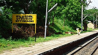
Ettimadai is an NSG–6 category Indian railway station in Palakkad railway division of Southern Railway zone. It is a railway station in the Coimbatore suburb of Ettimadai, Tamil Nadu, India. It is located between Madukkarai and Walayar. Trains from Coimbatore Junction railway station and Podanur Junction railway station heading to Palakkad Junction railway station passes through this station. It serves primarily for commutators of Amrita Vishwa Vidyapeetham university campus.

Amrita Vidyalayam is a chain of private CBSE schools run and managed by the Mata Amritanandamayi Math founded by Mata Amritanandamayi. There are more than 90 English medium, co-educational, Senior Secondary schools affiliated to Central Board of Secondary Education throughout India out of which more than 30 are in Kerala. It is one of the leading schools with 100 per cent pass in All India Secondary School Examination and All India Senior School Certificate Examination in consecutive years. They emphasise on value-based education, sports, extra curricular activities and excellence in competitive exams. It provides coaching for NEET-UG, JEE Main, CUET, Olympiads and other competitive exams with the help of its online learning platform Amrita Edge.

Kalpathy or Kalpathi is a residential area in Palakkad city, Kerala, India. It is famous for the Viswanatha Swamy Temple, which is located along the banks of the Kalpathy river, one of the tributaries of the Bharathapuzha. Kalpathy is also famous for its agraharam, or traditional village. It is the first heritage village in Kerala. There are around 4 agraharams of Brahmins who migrated from Tamil Nadu so many years ago to Kalpathy. Many temples, other than the Viswanatha Swamy Temple, are also present here. The annual festival Kalpathy Ratholsavam is held here, with chariots as the main attraction. Kalpathy and it's neighbourhoods have witnessed large settlements of people in colonies and apartments, making it one of the major residential areas of the city.


