Kovaipudur

Last updated

Kovaipudur
Neighbourhood
Kovaipudur.jpg
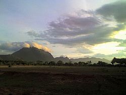
Skyline of Kovaipudur
Coordinates: 10°56′12″N76°57′4″E / 10.93667°N 76.95111°E / 10.93667; 76.95111 Coordinates: 10°56′12″N76°57′4″E / 10.93667°N 76.95111°E / 10.93667; 76.95111
CountryFlag of India.svg  India
State Tamil Nadu
District Coimbatore District
MetroCoimbatore
Time zone +5.30GMT
PIN
641042
Telephone code+91-422
Vehicle registration TN-99
Pasture land near the Kovaipudur stream Kovaipudur Pastures.jpg
Pasture land near the Kovaipudur stream

Kovaipudur is a large township at the foothills of the Western Ghats, located in the City of Coimbatore, Tamil Nadu, India. The Regional Transport Office (RTO) of Coimbatore West (TN 99) is located at Kovaipudur. People represent this city as Little Ooty due to its cool climate and serene environment, and was set up sometime in late seventies. Today this township has about 7500 families, three arts colleges, one engineering college, a polytechnic and a handful of schools. Kovaipudur has come under the Corporation of Coimbatore and became one of the average localities in Coimbatore.

Contents

Location

Semmozhi Poonga (Park) Park in Kovaipudur.jpg
Semmozhi Poonga (Park)

Kovaipudur lies at the mouth of the Palghat Pass and at the south western fringe of the Coimbatore city, bordering the Western Ghats at the foothills of the Madukkarai range in Coimbatore and the Walayar ranges in Kerala. Kovaipudur has mainly scrub vegetation as these hills make it a rainshadow area. The mean temperature is significantly lower than Coimbatore city.

There is a police training academy, along with numerous schools and colleges. Shanti Ashram, a renowned social organization of the region. Kovaipudur has a huge playground where sports like Cricket, Football, Volleyball and lots of other sports are played everyday by school and college students and even middle aged people. There is also an integrated township with a golf course.

A small park by the name 'Semmozhi Poonga' was opened for the general public. Many people come to the park for walking.

Business Establishments

Semmozhi Poonga (Park) Park in Kovaipudur.jpg
Semmozhi Poonga (Park)

Kovaipudur is also base for several famous business establishments.

Religious places

As the large majority of the population is Hindu, there are many Hindu temples like Sri.Rukmini Satyabhama Samedha Sri.Venugopala Perumal and Sridevi Boodevi Samedha Kalyana Venkatesa Perumal temple, Nagapillayar, Kasi Visalakshi, Sundara Vinayagar, Sri Gopalaswamy, Sri Ragavendraswamy and Lord Ayyapa. In addition, there are Infant Jesus Church, [1] IPA Faith City Church, CSI Christ Church, few other protestant churches and a masjid.

Entrance of Infant Jesus Church Infant Jesus Church Coimbatore.jpg
Entrance of Infant Jesus Church
Vimhana of Venugopal Swami temple Perumal Kovil Kovaipudur.jpg
Vimhana of Venugopal Swami temple
Nagapillayar Kovil Nagapillayar Temple.jpg
Nagapillayar Kovil

Environment

Temperatures are cooler than Coimbatore city on an average. From April to May, the SW monsoon winds pass over Malampuzha dam waters in Kerala. From June to September, the winds pass through the rain drops and over the dam waters, cooling the air like in an evaporating air cooler. From October to March, the NW monsoon winds bring rain to Kovaipudur. The breeze velocity is high due to the venturi effect of the Palghat pass.


Related Research Articles

<span class="mw-page-title-main">Western Ghats</span> Mountain range along the western coast of India

The Western Ghats or the Western Mountain range is a mountain range that covers an area of 160,000 km2 (62,000 sq mi) in a stretch of 1,600 km (990 mi) parallel to the western coast of the Indian peninsula, traversing the states of Gujarat, Maharashtra, Goa, Karnataka, Kerala and Tamil Nadu. It is a UNESCO World Heritage Site and is one of the eight biodiversity hotspots in the world. It is sometimes called the Great Escarpment of India. It contains a very large proportion of the country's flora and fauna, many of which are endemic to this region. According to UNESCO, the Western Ghats are older than the Himalayas. They influence Indian monsoon weather patterns by intercepting the rain-laden monsoon winds that sweep in from the south-west during late summer. The range runs north to south along the western edge of the Deccan Plateau and separates the plateau from a narrow coastal plain called Konkan along the Arabian Sea. A total of 39 areas in the Western Ghats, including national parks, wildlife sanctuaries and reserve forests, were designated as world heritage sites in 2012 – twenty in Kerala, ten in Karnataka, six in Tamil Nadu and four in Maharashtra.

<span class="mw-page-title-main">Erode district</span> District of Tamil Nadu in India

Erode District is one of the 38 districts in the state of Tamil Nadu in India. It was the largest district by area in the state before the formation of Tirupur District in 2009. The headquarters of the district is Erode. It is divided into two revenue divisions, Erode and Gobichettipalayam, and is further subdivided into 10 taluks. Erode District was a part of Coimbatore District before its division into two on 17 September 1979. It covers an area of 5,722 square kilometres (2,209 sq mi), and as of 2011, had a population of 2,251,744.

<span class="mw-page-title-main">Perumal (deity)</span> Hindu deity

Perumal or Tirumal is a Hindu deity. Perumal is worshipped mainly among Tamil Hindus in South India, Sri Lanka, and the Tamil diaspora, who consider Perumal to be a form of Vishnu.

<span class="mw-page-title-main">Palakkad Gap</span> Mountain pass in South India

Palakkad Gap or Palghat Gap is a low mountain pass in the Western Ghats between Coimbatore in Tamil Nadu and Palakkad in Kerala. It has an average elevation of 140 metres (460 ft) with a width of 24–30 kilometres (15–19 mi). The pass is located between the Nilgiri Hills to the north and Anaimalai Hills to the south.

<span class="mw-page-title-main">Chera dynasty</span> 300s BCE – 1100s CE Tamil dynasty in ancient South India

The Chera dynasty, IPA: [t͡ʃeːɾɐ], was one of the South dynasties in and before the Sangam period history of the state of Kerala and the Kongu Nadu region of Western Tamil Nadu in southern India. Together with the Tamil dynasties of Cholas of Uraiyur (Tiruchirappalli) and the Pandyas of Madurai, the early Cheras were known as one of the three major powers (muventar) of ancient Tamilakam in the early centuries of the Common Era. They are credited as the creators of land of Kerala as they have unified various regions of the western coast and western ghats to form the early Kerala empire.

<span class="mw-page-title-main">Mattanur</span> Municipality in Kerala, India

Mattanur, also spelled Mattannur, is a town, municipality, and an aerotropolis in Kannur district, Kerala, India. Mattanur is about 27 km east of Kannur and Thalassery, two major towns of the district.

<span class="mw-page-title-main">Uzhavoor</span> Town in Kerala, India

Uzhavoor is an expanding town in Kottayam district, Kerala in India. It is just 32 km away from the administrative capital Kottayam District. Most of its residents are either wealthy farmers or businessmen. Many of the houses belong to NRIs. The tenth President of India, K. R. Narayanan, was born and brought up in this village. The newly expanded road which connects the city of Pala and other destinations such as Sabarimala to the city of Muvattupuzha passes through Uzhavoor. The town is 177 km from the state capital Thiruvananthapuram.

<span class="mw-page-title-main">Coimbatore district</span> District of Tamil Nadu in India

Coimbatore district is one of the 38 districts in the state of Tamil Nadu in India. Coimbatore is the administrative headquarters of the district. It is one of the most industrialized districts and a major textile, industrial, commercial, educational, information technology, healthcare and manufacturing hub of Tamil Nadu. The region is bounded by Tiruppur district in the east, Nilgiris district in the north, Erode district in the north-east, Palakkad district, Idukki district and small parts of Thrissur district and Ernakulam district of neighboring state of Kerala in the west and south respectively. As of 2011, Coimbatore district had a population of 3,458,045 with a sex-ratio of 1,000 and literacy rate of 84%.

<span class="mw-page-title-main">Thrissur district</span> District in Kerala, India

Thrissur, is one of the 14 districts in the Indian state of Kerala. It is situated in the central part the state. Spanning an area of about 3,032 km2 (1,171 sq mi), Thrissur district is home to over 9% of Kerala's population.

<span class="mw-page-title-main">Pollachi</span> Town in Tamil Nadu, India

Pollachi is a town and a taluk headquarters in Coimbatore district, Tamil Nadu state, India. Located about 40 km (25 mi) to the south of Coimbatore, it is the second largest town in the district after Coimbatore. Pollachi is a popular Marketplace for jaggery, vegetables and cattle. As of 2011, the town had a population of 90,180.

<span class="mw-page-title-main">Batlagundu</span> City in Tamil Nadu, India

Batlagundu is a town in Nilakottai block in Dindigul district in the Madurai Region state of Tamil Nadu, India. The name Vetrilaikkundru later transformed and changed to Vathalagundu. The town is the major gateway to Kodaikanal. Subramaniya Siva was a writer, Indian Freedom Fighter, and activist born in Batlagundu. Batlagundu is the fifth-largest town in the Dindigul district. The town is located in such a way connecting three main districts of South Tamil Nadu. Batlagundu has most of the voters in Nilakottai Constituency.

Cumbum or Kambam, is a town and municipality in Theni district, an Indian state of Tamil Nadu.

Kinathukadavu, meaning Pass of the Well, is a town panchayat suburb of Coimbatore city and taluk in Coimbatore district in the Indian state of Tamil Nadu. It is along the National Highway 209 and is 23 kilometres (14 mi) from Gandhipuram heart of Coimbatore city and 20.5 kilometres (13 mi) from Pollachi town. Neighboring places are Othakalmandapam, Malumichampatti, Eachanari to name a few.

<span class="mw-page-title-main">Udumalaipettai</span> Town in Tamil Nadu, India

Udumalai, also known as Udumalaipettai and Udumalpet, is a town in Tiruppur district in the Indian state of Tamil Nadu. Udumalaipettai is located 535 km south west from the state capital, Chennai and 72 km away from Coimbatore, the second largest city in the state.

<span class="mw-page-title-main">Valparai</span> Town in Tamil Nadu, India

Valparai is a Taluk and hill station in the Coimbatore district of Tamil Nadu, India. It consists of Anamalai Tiger Reserve. It is located 3,474 feet (1,059 m) above sea level on the Anaimalai Hills range of the Western Ghats. There are a total of 56 estates here. The game of football is very popular here. State level competitions are held every year. The foothill starts exactly from Monkey Falls which is at a distance of 38 kilometres (24 mi) to Valparai. The route to Valparai from the foothills consists of 40 hairpin bends. The Kerala state border town of Malakkappara is at a distance of 27 kilometres from Valparai. While major portions of the land are owned by private tea companies, large forest areas continue to be out of bounds.

Kulasekharam is a town located in the district of Kanyakumari, Tamil Nadu, India. It is one of the most important business centres in the district, after Marthandam.

<span class="mw-page-title-main">Poonjar</span> Town in Kerala, India

Poonjar is a small Indian town located on the eastern side of Kottayam district in Kerala state, India. Before the independence of India, Poonjar had been the part of Travancore princely state.Erattupetta, Teekoy, bharananganam, and vagamon are the nearest towns and villages of Poonjar.Taluk headquarters,pala is 18 kilometres away from poonjar and kanjirapally is 22.6 kilometres away from poonjar

<span class="mw-page-title-main">Somayanur</span> Village Skyline in Tamil Nadu, India

Somayanur village is part of 22 Nanjundapuram Panchayat located in Coimbatore, Tamil Nadu, India.

<span class="mw-page-title-main">Geography of Coimbatore</span>

Coimbatore is the second largest city in the Indian state of Tamil Nadu. It is situated in the western corner of Tamil Nadu, a short distance from the border with the neighbouring state of Kerala, and is surrounded by the Western Ghats on all sides.

References