Peelamedu

Last updated

Peelamedu
Neighbourhood
Peelamedu bridge.jpg
PSG Bridge, Avinashi Road, Peelamedu (2016)
India Tamil Nadu location map.svg
Red pog.svg
Peelamedu
Location in Tamil Nadu, IndiaIndial
Coordinates: 11°01′36″N77°01′16″E / 11.0266292°N 77.0212188°E / 11.0266292; 77.0212188
CountryIndia
State Tamil Nadu
District Coimbatore
MetroCoimbatore
Area
  Total7 km2 (3 sq mi)
Elevation
418 m (1,371 ft)
Languages
  Official Tamil
Time zone UTC+5:30 (IST)
PIN
641004
Telephone code91–422
Vehicle registration TN 37 (Peelamedu RTO)
Lok Sabha constituency Coimbatore
Vidhan Sabha constituency Singanallur

Peelamedu is a major commercial centre and residential locality in the Eastern part of the city of Coimbatore in Tamil Nadu, India. It is governed by Coimbatore City Municipal Corporation since 1981. The growth of Peelamedu during the last decade can be cited due to the growth of the IT sector in Coimbatore. The rapid growth of Peelamedu as a commercial and residential hub could be attributed to its geographical advantage in terms of the connectivity to other parts of the city. It acts as an important hub connecting the rapidly growing business class Information Technology corridor. The Peelamedu area stretches from Nava India to the Coimbatore International Airport near SITRA, encompassing major educational institutions, hospitals, and Industries.

Contents

History

The foundation stone for "Peelamedu" was laid in November 11, 1711. It was after much persuasion that the King of Mysore, Kanthirava Narasaraja II, granted a permission to Naidu Community people to establish the Peelamedu village [1] On 11 November 2011, Peelamedu celebrated the locality's 300th anniversary with special arrangement in schools and colleges and poojas in temples. [2]

Etymology

The name "Peelamedu" is derived from "Poolai Medu". The area with an elevation of 418 metres and Poolai flowers plantation abundant then in 1711, the locality was named as "Poolaimedu". [3]

Geography

Avinashi Road, Coimbatore is maintained by the Highways and Minor Ports Department. This 17-km stretch of road running diagonally across this suburb has become the hub of business for Peelamedu. The other major arterial roads include Kamarajar Road, Fun Mall Road, Gandhimanagar Road, Tidel Park Road and Cheranmangar Road, Sowripalayam Road.

Peelamedu is surrounded by localities such as Pappanaickenpalayam, Uppilipalayam, Singanallur, Varadharajapuram, Gandhimanagar, Vilankurichi, Ganapathymanagar, Chinniampalayam, Kalapatti and SIHS Colony.

Economy

Major textile and wet grinder industries and a considerable number of foundries and motor/pump industries of the district are also located here. It is the educational hub of Coimbatore, with renowned Medical, Paramedical, Engineering, Arts & Science colleges and many famous schools situated here.

Infrastructure

Avinashi Road Flyover

The Avinashi Road Elevated Expressway is a 10.01-kilometre-long (6.22 mi), four-lane, elevated expressway under construction in the city of Coimbatore, Tamil Nadu, India. [4] The corridor begins near the Uppilipalayam Flyover and ends near the Goldwins junction over the Avinashi Road, the most important arterial road in the city bypassing over 12 traffic intersections.
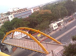
Railway Flyovers

A railway flyover is under construction near Tidel Park. Peelamedu RS Flyover was opened in 2016 to avoid traffic congestion.

Temples

In the area, Temple like

Multi-Speciality Hospitals

Major Malls

Educational institutions

Peelamedu is a center of education in Coimbatore

Colleges

Schools

IT Parks

Other Places

Media & Production House

Coimbatore International Airport

Coimbatore International Airport. Domestic terminal at CJB.JPG
Coimbatore International Airport.

Coimbatore International Airport is the second largest and busiest airport in the state of Tamilnadu is located at Peelamedu.

Connectivity

Peelamedu has easy access to :

Coimbatore Metro

Coimbatore Metro feasibility study is completed and one of the route planned from Ukkadam Bus Terminus to Kaniyur via Peelamedu and Coimbatore International Airport covering 27 km. [5]

Politics

The locality of Peelamedu is a part of Singanallur (state assembly constituency) and Coimbatore (Lok Sabha constituency). [6]

Related Research Articles

<span class="mw-page-title-main">TIDEL Park</span> Tech Park in Chennai, India

TIDEL Park is an information technology (IT) park situated in the city of Chennai, India. The name TIDEL is a portmanteau of TIDCO and ELCOT. An ISO 9001/14001 company, In 2000, it was one of the largest IT parks in India. It was set up in 2000 to foster the growth of information technology in the state of Tamil Nadu by the TIDEL Park Ltd, a joint venture of TIDCO and ELCOT.

Karumathampatti is a Municipality in the Coimbatore district in the state of Tamil Nadu, India. It is one of the prominent developing suburb in Coimbatore metropolitan area, about 25 km away from the city centre. It is situated in between NH544 which connects the city of Coimbatore with Salem – Erode – Tirupur and also in between the State Highway 165 connects Annur – Kamanaikenpalayam. Nearby places are Somanur-3 km, Avinashi-10 km, Tirupur-20 km, Sulur-15 km, Annur-16 km. Coimbatore -27,Mettupalayam-38,Palladam-19. Karumathampatti lies near the junction of two major roads, NH544(Coimbatore – Salem) and Karumathampatti – Annur road.

<span class="mw-page-title-main">Coimbatore International Airport</span> Airport in Coimbatore, Tamil Nadu, India

Coimbatore International Airport is an international airport and the primary airport serving the industrial cities of Coimbatore, Erode and Tiruppur in Tamil Nadu, India. It is located in the neighbourhood of Peelamedu, about 10 km (6.2 mi) from Coimbatore's city centre. It is the 18th-busiest airport in India for passengers handled, 17th-busiest for total aircraft movement and 15th-busiest for cargo handled. The airport is served by five Indian and three foreign carriers providing direct connectivity to nine domestic and three international destinations.

Avarampalayam is a part of the Coimbatore city. It is located in close proximity to Peelamedu, Nava India, Ganapathy. It houses the large number of foundries and motor / pump industries. It is one of the head place of small scale industries & medium scale industries in Coimbatore. It played a major role for industrial revolution in Coimbatore.It has many small scale foundries and large number of small-scale industries & also some medium scale industries.

Ukkadam is a part of Townhall locality in the core part of the city of Coimbatore, Tamilnadu, India. Ukkadam Bus Terminal, which is one of the seven major bus stands in the city, is located in this neighborhood. Ukkadam is famous for its Fish Market and Jackfruit Market.

Ganapathy is a residential neighbourhood in the city of Coimbatore in Tamil Nadu, India. It is located in the north-eastern part of the city. This is the most densely populated area within Coimbatore Corporation limits.

Udayampalayam is part of Coimbatore North in the Indian state of Tamil Nadu. It is located 7 km from Coimbatore Railway Station and 18 km from the airport. This is the northern border of the Coimbatore corporation.

<span class="mw-page-title-main">Puliakulam</span> Coimbatore, Tamil Nadu, INDIA

Puliakulam is a residential neighborhood in the city of Coimbatore. The Idol in Puliakulam Vinayagar Temple is one of the largest monolithic(Single stoned) statues and the largest Ganesha idol in Asia. The Temple is Situated on the middle of the Four road Junction and also acts as a roundabout for the Vehicles to pass by. The idol is in the East facing the Meena estate and the Sowripalayam Road.

Ramanathapuram is a locality in Coimbatore city on the south eastern part of the city. It is one of the well developed neighborhoods in the city and has been part of Coimbatore Corporation since 1882.

<span class="mw-page-title-main">Transport in Coimbatore</span>

Coimbatore is a city in the state of Tamil Nadu, India. Most transportation in the city and suburbs is by road. Coimbatore is well-connected to most cities and towns in India by road, rail, and air, but not through waterways. The city has successful transport infrastructure compared to other Indian cities, though road infrastructures are not well maintained and developed according to the growing needs of transport, making traffic congestion a major problem in the city. A comprehensive transport development plan has been made to address many traffic problems.

<span class="mw-page-title-main">TIDEL Park Coimbatore</span> Information technology park in Tamil Nadu, India

TIDEL Park Coimbatore is an information technology (IT) park located in Coimbatore, India. It was set up in 2006 to foster the growth of information technology in other districts of Tamil Nadu by TIDEL Park Ltd, a joint venture of Tamil Nadu Industrial Development Corporation (TIDCO) and Electronics Corporation of Tamil Nadu (ELCOT). The name TIDEL is a portmanteau of TIDCO and ELCOT and also named after TIDEL Park at Chennai.

<span class="mw-page-title-main">Avinashi Road, Coimbatore</span>

Avinashi Road, is an arterial road in Coimbatore, India. Running from east to west, the road starts at Uppilipalayam flyover and ends at Neelambur by-pass junction where it joins NH 544, Beyond Neelambur Junction, the road branches into two, with one traversing southwards to Madukarai to form the Coimbatore bypass while the other continues westwards to Avinashi and beyond to form the National Highway 544. This road connects Coimbatore to its airport and the east and north-east suburbs. The road was an indicator of development as the city of Coimbatore grew up mostly along its eastern and western sides.

Kurumbapalayam SSKulam is a part of Coimbatore city in the state of Tamil Nadu, India. It is located on NH 209 between Saravanampatti and Annur.

<span class="mw-page-title-main">Trichy Road, Coimbatore</span> Arterial road in Coimbatore, India

Trichy Road is an arterial road in Coimbatore, India. This road connects the city to Singanallur Bus Terminus and Sulur Air Force Station and the east and south-east suburbs in the Coimbatore metropolitan area. This road, along with Avinashi Road reveals Coimbatore's development, mostly along the eastern and western sides of these roads. It is considered to be one of the arterial roads with lesser traffic congestion.

<span class="mw-page-title-main">Singanallur</span> Coimbatore, Tamil Nadu, India

Singanallur is a major residential locality of the city of Coimbatore in Tamil Nadu, India. It is located on the banks of Noyyal river, which runs to the southern boundary of the locality. It is situated in the eastern part of the city, and is a major hub for the inter-city bus services towards Southern and Central districts of Tamilnadu from the city. It is one of the well developed neighborhoods in the city and has been part of Coimbatore Corporation since 1981. The East Zone Office of Coimbatore City Municipal Corporation is located at Singanallur.

Coimbatore is the second largest city in the state of Tamilnadu in India. The major arterial roads in the city are Avinashi Road, Trichy Road, Pollachi Road, Sathy Road, Palakkad Road, Mettupalayam Road and Thadagam Road. Coimbatore city is served by many flyovers. Avinashi road flyover in Coimbatore was built in 1974 and was the second flyover to be opened in Tamil Nadu after the Anna flyover in Chennai. It was also the first grade separator in India to have a roundabout.

Kamarajar Road is an arterial road in city of Coimbatore, Tamil Nadu, India. This road connects Singanallur and Hope College.It acts as a major link between Avinashi Road and Trichy Road,the two major arterial roads in Coimbatore city.

The Avinashi Road Elevated Expressway is a 10.10-kilometre-long (6.28 mi), four-lane, elevated expressway under construction in the city of Coimbatore, Tamil Nadu, India. The corridor begins near the Uppilipalayam Flyover and ends near the Goldwins junction over the Avinashi Road, the most important arterial road in the city, bypassing over 12 traffic intersections. Upon completion, this would be the longest elevated corridor in Tamil Nadu, and the second longest in India after the P. V. Narasimha Rao Expressway.

Nanjundapuram is a residential neighbourhood of the city of Coimbatore in Tamil Nadu, India. It is one of the well developed neighborhoods in the city and has been part of Coimbatore Corporation since 1981. The name "Nanjundapuram" is derived from the Nanjundeshwarar Temple located on the banks of Noyyal river.

Selvapuram is a major residential locality of the city of Coimbatore in Tamil Nadu, India. It is located on the banks of Noyyal river, which runs to the northwestern boundary of the locality. It is situated in the northwestern part of the city, and is a major residential and industrial locality in the city. It is one of the well developed neighborhoods in the city and has been part of Coimbatore Corporation since 1866.

References

  1. "The 300 year history of Peelamedu". The Covai Post. 27 September 2020. Retrieved 23 January 2022.
  2. Srinivasan, Pankaja (11 November 2011). "Happy 300th birthday Peelamedu!". Coimbatore: The Hindu . Retrieved 9 March 2012.
  3. "About Peelamedu". The Covai Post. 27 September 2020. Retrieved 23 January 2022.
  4. "Preliminary work begins on Avinashi Road flyover". The Times of India. 27 September 2020. Retrieved 30 May 2021.
  5. "Rs 6,683cr allocated for city metro rail project". The Times of India. Retrieved 14 April 2021.
  6. "Singanallur Legislative Assembly Constituency". The Hindu. Retrieved 14 April 2021.