
Jammu and Kashmir was a state of India from 1954 to 2019, constituting the southern and southeastern portion of the larger Kashmir region, which has been the subject of a dispute between India, Pakistan and China since the mid-20th century. The underlying region of this state were parts of the former princely state of Jammu and Kashmir, whose western districts, now known as Azad Kashmir, and northern territories, now known as Gilgit-Baltistan, are administered by Pakistan. The Aksai Chin region in the east, bordering Tibet, has been under Chinese control since 1962.
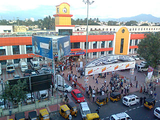
Coimbatore, also known as Kovai or sometimes spelt as Covai, is one of the major metropolitan cities in the Indian state of Tamil Nadu. It is located on the banks of the Noyyal River and surrounded by the Western Ghats. Coimbatore is the second largest city in Tamil Nadu after Chennai and the 16th largest urban agglomeration in India as per the census 2011. It is administered by the Coimbatore Municipal Corporation and is the administrative capital of Coimbatore District. In 1981 Coimbatore formed as third municipal corporation in Tamil Nadu after Chennai and Madurai. Podanur Junction is the oldest Railway station in Coimbatore City. The city is one of the largest exporters of jewellery, wet grinders, poultry and auto components; the "Coimbatore Wet Grinder" and the "Kovai Cora Cotton" are recognised as Geographical Indications by the Government of India. It is known as the Manchester of South India as it is a hub of textile industry in South India. It was ranked the 7th best city in India in the Ease of Living index 2020.

Wayanad is an Indian district in the north-east of Kerala state with administrative headquarters at the municipality of Kalpetta. It is the sole Plateau in Kerala. The Wayanad Plateau forms a continuation of Mysore Plateau, which is the southern portion of Deccan Plateau. It is set high on the Western Ghats with altitudes ranging from 700 to 2100 meters. Vavul Mala, a 2,339 m high peak situated on the trijunction of Wayanad, Malappuram, and Kozhikode districts, is the highest point in Wayanad district. The district was formed on 1 November 1980 as the 12th district in Kerala by carving out areas from Kozhikode and Kannur districts. About 885.92 sq.km of area of the district is under forest. Wayanad has three municipal towns—Kalpetta, Mananthavady and Sulthan Bathery. There are many indigenous tribals in this area. The Kabini River, which is a tributary of Kaveri River, originates at Wayanad. Wayanad district, along with the Chaliyar valley in neighbouring Nilambur region in Malappuram district, is known for natural Gold fields, which is also seen in other parts of Nilgiri Biosphere Reserve. Chaliyar river, which is the fourth longest river of Kerala, originates in Wayanad plateau. The historically important Edakkal Caves are located in Wayanad district.

Palakkad District, in the southeastern part of the former Malabar district, is one of the 14 districts of the Indian state of Kerala. It is located right in the middle of the state. Also, it is the largest district in Kerala since 2006. The city of Palakkad is the district headquarters. Palakkad is bordered on the northwest by the Malappuram District, on the southwest by the Thrissur District, on the northeast by Nilgiris District, and on the east by Coimbatore district of Tamil Nadu. The district is nicknamed "the granary of Kerala". Palakkad is the gateway to Kerala due to the presence of the Palakkad Gap, in the Western Ghats. The 2,383 m high Anginda peak, which is situated in the border of Palakkad district, Nilgiris district, and Malappuram district, in Silent Valley National Park, is the highest point of elevation in Palakkad district. Palakkad city is located just 50 km away from Coimbatore, which is the second-largest city in Tamil Nadu, only after to Chennai.

Kanyakumari district is one of the 38 districts in Tamil Nadu state and the southernmost district in mainland India. It stands second in terms of population density among the districts of Tamil Nadu and the second most urbanized, next only to Chennai district. It is also the richest district in Tamil Nadu in terms of per capita income, and also tops the state in Human Development Index (HDI), literacy, and education. The district's headquarters is Nagercoil.

Coimbatore district is one of the 38 districts in the state of Tamil Nadu in India. Coimbatore is the administrative headquarters of the district. It is one of the most industrialized districts and a major textile, industrial, commercial, educational, information technology, healthcare and manufacturing hub of Tamil Nadu. The region is bounded by Tiruppur district in the east, Nilgiris district in the north, Erode district in the north-east, Palakkad district, Idukki district and small parts of Thrissur district and Ernakulam district of neighboring state of Kerala in the west and south respectively. As of 2011, Coimbatore district had a population of 3,458,045 with a sex-ratio of 1,000 and literacy rate of 84%.

Annur is a town panchayat and taluk headquarters of Annur Taluk of Coimbatore district. It is a suburb of Coimbatore city located north-east about 30 kilometres from the center of the city. Nearest airport is Coimbatore International Airport, which is about 27 kilometres and the nearest railway station is Mettupalayam, which is about 21 kilometres away. Other cities/towns nearby Annur are Mettupalayam, which is 21 kilometres away in the west, Avanashi, which is 18 kilometres away in the east and Punjai Puliampatti, which is about 18 kilometres in the north. Annur has police station with Karumathampatti sub division.
Kadayampatti is a town panchayat and headquarters of Kadayampatti taluk, in Salem district, Tamil Nadu, India.

Kasaragod is one of the 14 districts in the southern Indian state of Kerala. It's northern border Thalappady is located just 10 km south to Ullal, which is the southernmost portion of the major port city Mangalore, on the southwestern Malabar coast of India.

The Coimbatore Corporation is the civic body that governs the city of Coimbatore in the Indian state of Tamil Nadu. The corporation is Tamil Nadu's second largest after the Greater Chennai Corporation with an area of 246.75 km2.
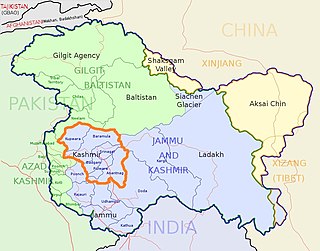
The Kashmir Division is a revenue and administrative division in the Kashmir Valley region of Jammu and Kashmir. It borders Jammu Division to the south and the union territory of Ladakh to the east, while the Line of Control forms its border with the Pakistan-administered territories of Jammu and Kashmir and Pakistani-administered territories of Gilgit−Baltistan to the north and west, respectively.
Wayanad district, which is home to Edakkal Caves, has human settlement from prehistoric era. Wayanad is the sole Plateau in Kerala.

Jammu and Kashmir is a region administered by India as a union territory and consists of the southern portion of the larger Kashmir region, which has been the subject of a dispute between India and Pakistan since 1947, and between India and China since 1962. The Line of Control separates Jammu and Kashmir from the Pakistani-administered territories of Azad Kashmir and Gilgit-Baltistan in the west and north. It lies to the north of the Indian states of Himachal Pradesh and Punjab and to the west of Ladakh, which is also subject to the dispute as a part of Kashmir, and administered by India as a union territory.
The Coimbatore Metropolitan Area, or Coimbatore Urban Agglomeration, is the sixteenth-most populous metropolitan area in India, the second most populous metropolitan area in the state of Tamil Nadu next only to Chennai. The Coimbatore Metropolitan Area consists of the city of Coimbatore and its suburbs in Coimbatore and Tiruppur districts.
Neelambur is a census town in Coimbatore district in the Indian state of Tamil Nadu.
Pattanam is a census town and a suburb in Coimbatore district in the Indian state of Tamil Nadu.
Kaniyur is a census town and a suburb in Coimbatore district in the Indian state of Tamil Nadu.
Arasur is a census town and a suburb in Coimbatore district in the Indian state of Tamil Nadu.
Muthugoundanpudur is a census town and a suburb in Coimbatore district in the Indian state of Tamil Nadu.

