
Tamil Nadu is a state in South India. Its capital and largest city is Chennai. Tamil Nadu lies in the southernmost part of the Indian subcontinent and is bordered by the union territory of Puducherry and the South Indian states of Kerala, Karnataka, and Andhra Pradesh. It is bounded by the Eastern Ghats on the north, by the Nilgiri Mountains, the Meghamalai Hills, and Kerala on the west, by the Bay of Bengal in the east, by the Gulf of Mannar and the Palk Strait on the southeast, and by the Indian Ocean on the south. The state shares a maritime border with the nation of Sri Lanka. Its official language is Tamil, which is one of the longest-surviving classical languages in the world.
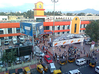
Coimbatore, also known as Kovai or sometimes spelt as Covai, is one of the major metropolitan cities in the Indian state of Tamil Nadu. It is located on the banks of the Noyyal River and surrounded by the Western Ghats. Coimbatore is the second largest city in Tamil Nadu after Chennai and the 16th largest urban agglomeration in India as per the census 2011. It is administered by the Coimbatore Municipal Corporation and is the administrative capital of Coimbatore District. In 1981 Coimbatore formed as third municipal corporation in Tamil Nadu after Chennai and Madurai. Podanur Junction is the oldest Railway station in Coimbatore City. The city is one of the largest exporters of jewellery, wet grinders, poultry and auto components; the "Coimbatore Wet Grinder" and the "Kovai Cora Cotton" are recognised as Geographical Indications by the Government of India. It is known as the Manchester of South India as it is a hub of textile industry in South India. It was ranked the 7th best city in India in the Ease of Living index 2020.

Sathyamangalam is a town and municipality in Erode district in the Indian state of Tamil Nadu. 8 th century Town. It lies on the banks of the River Bhavani, a tributary of the River Cauvery in the foothills of the Western Ghats. It is about 65 km from Erode, 58 km from Tiruppur and 70 km from Coimbatore. As of 2011, the town had a population of 37,816.
Dharmapuri, is a town in the western part of Tamil Nadu, India. The town is located at 50 km from Krishnagiri, 69 km from Salem, 126 km from Bangalore, 200 km from Coimbatore, and 300 km from the state capital Chennai. It is located between latitudes N 11 47’ and 12 33’ and longitudes E 77 02’ and 78 40’. It is one of top leading mango cultivator and producer of state.
Sattur or Saathur is a town in Virudhunagar district in the Indian state of Tamil Nadu. As of 2011, the town had a population of 29,398.

Coimbatore district is one of the 38 districts in the state of Tamil Nadu in India. Coimbatore is the administrative headquarters of the district. It is one of the most industrialized districts and a major textile, industrial, commercial, educational, information technology, healthcare and manufacturing hub of Tamil Nadu. The region is bounded by Tiruppur district in the east, Nilgiris district in the north, Erode district in the north-east, Palakkad district, Idukki district and small parts of Thrissur district and Ernakulam district of neighboring state of Kerala in the west and south respectively. As of 2011, Coimbatore district had a population of 3,458,045 with a sex-ratio of 1,000 and literacy rate of 84%.
Pollachi is a town and a taluk headquarters in Coimbatore district, Tamil Nadu state, India. Located about 40 km to the south of Coimbatore, it is the second largest town in the district after Coimbatore. Pollachi is a popular Marketplace for jaggery, vegetables and cattle. As of 2011, the town had a population of 90,180.

Dharapuram officially Tharaapuram is a town in Tirupur district in the Indian state of Tamil Nadu. Dharapuram is one of the oldest towns in Tamil Nadu and was the capital of Kongu Nadu under the Cheras, Western Ganga Dynasty and later Kongu Cholas, at which time it was known as Vanchipuri. Amaravathi River flows through the town. As of 2011, the town had a population of 67,007. Dharapuram Municipality is promoted 1st grade municipality on 6 May 1983 Dharapuram was Part of Coimbatore district in the beginning and later it moves to Erode district up to 2009. Dharapuram Town is situated along the banks of River Amaravathi, located in between 10 degree 45 minutes northern latitude and 77 degree 31 minutes eastern latitude with an extent of 7.02 km2. It is a small agricultural marketing centre for a large rural hinterland in the Tirupur District. The town is 50 km towards of the District Headquarters Tirupur, 75 km towards the Erode and 72 km towards the industrial town Coimbatore. The nearest airport is Coimbatore International Airport located 70 km from Dharapuram. Dharapuram was the capital of Noyyal South District before the formation of Coimbatore District.
Oddanchatram is a town in Dindigul district in the Indian state of Tamil Nadu. Oddanchatram is a region in the southwest of Tamil Nadu. The Town was carved out of Madurai District in 1985. Oddanchatram is also famous for vegetable and cattle market. It is located at the base of the western ghats in South India. As of 2011, the town had a population of 30,064. It is known as vegetable city of Tamil Nadu. Oddanchatram vegetable market is the largest supplying of vegetables in Tamilnadu and Kerala. Agriculture is the major economic support for the town.
Kinathukadavu, meaning Pass of the Well, is a town panchayat suburb of Coimbatore city and taluk in Coimbatore district in the Indian state of Tamil Nadu. It is along the National Highway 209 and is 23 kilometres (14 mi) from Gandhipuram heart of Coimbatore city and 20.5 kilometres (13 mi) from Pollachi town. Neighboring places are Othakalmandapam, Malumichampatti, Eachanari to name a few.
Kurichi is a neighborhood of Coimbatore city in the Indian state of Tamil Nadu. It was upgraded to a municipality in 2004, it was recently merged with the Coimbatore Corporation. As of 2011, the town had a population of 123,770
Mettupalayam is a taluk and municipality in the Coimbatore district in the Indian state of Tamil Nadu. It is located to the north of the city of Coimbatore on the way to Ooty. Mettupalayam is well known for their humble behaviour with other persons who come from outside of Mettupalayam. Mettupalayam is recognised as a Bio diversity Hotspot in India. In 2018 the Former Indian captain, MS Dhoni visited Mettupalayam for its Beauty and stayed there for about 5 weeks in one of his Fan's home. It is located in the foothills of Nilgiri hills about 35 km north of downtown Coimbatore and about 50 km north of Tiruppur, Mettupalayam is the third largest town in the district. As of 2011, the town had a population of 66,595. It is important for the Nilgiri ghat road.

Palladam is a town and First Grade Municipality in Tirupur district in the state of Tamil Nadu, India. It is the headquarters of Palladam Taluk of Tirupur district. Palladam is located on National Highway NH 81. Palladam is a major Town with large source of income collected from the business community which includes Textile industries, Poultry farms and Agriculture. Palladam High-tech weaving park is a milestone of the town. It is a part of the Coimbatore MP Constituency. Palladam is well known for production of Broiler chicken production and head office of Broiler coordination committee (BCC) situated here.
Veerakeralam is within the corporation limits of Coimbatore city in the Indian state of Tamil Nadu. It is It lies on extreme part of westside of the city.
Vellakovil is a municipal town in Kangeyam taluk of Tirupur District, in the Indian state of Tamil Nadu. It is located on National Highway 81 between Trichy and Coimbatore. The town is spread in an area of 64.75 km2. As of 2011, the town had a population of 40,359. Kannapuram village located near to this town is famous for Kangeyam breed cattle market that happens on every year during Mariyamman temple festival. It is an industrialized town with traditional agriculture being the occupation for most of the people. It holds lot of Power looms weaving bedsheets, floor mats and cotton materials being exported to foreign countries via exporters present in Karur.
Pallapalayam is a Town panchayat in Coimbatore district in the Indian state of Tamil Nadu.
Pollachi taluk is a taluk of Coimbatore rural district of the Indian state of Tamil Nadu. The headquarters is the town of Pollachi.
Vellakinar is one of the localities of the Coimbatore city in Tamil Nadu,India.Vellakinar is located on the stretch of Mettupalayam road in Coimbatore. Neighbourhing places of Vellakinar are Thudiyalur, Goundampalayam, GN Mills(Gnanambikai Mills). Tamil Nadu Housing Board colony, Sreevatsa Gardens, Samathuvapuram and Meenakshi Gardens, Coimbatore are main residential areas in Vellakinar panchayat. Vellakinar was added to the Coimbatore municipal corporation.

Tiruppur or Tirupur is a city in the Indian state of Tamil Nadu. Tiruppur is the administrative headquarters of Tiruppur district and the Sixth largest city as well as urban agglomeration in Tamil Nadu. Located on the banks of Noyyal River, it has been ruled at different times, by the Early Pandyas, Medieval Cholas, Later Cholas, Mysore Kingdom and the British. It is about 450 kilometres (280 mi) southwest of the state capital Chennai about 50 kilometres (31 mi) east of Coimbatore 50 kilometres (31 mi) south of Erode and 50 kilometres (31 mi) north of Dharapuram.
The Coimbatore Metropolitan Area, or Coimbatore Urban Agglomeration, is the sixteenth-most populous metropolitan area in India, the second most populous metropolitan area in the state of Tamil Nadu next only to Chennai. The Coimbatore Metropolitan Area consists of the city of Coimbatore and its suburbs in Coimbatore and Tiruppur districts.
