
The Western Ghats aka Sahyadri is a mountain range that covers an area of 160,000 km2 (62,000 sq mi) in a stretch of 1,600 km (990 mi) parallel to the western coast of the Indian peninsula, traversing the states of Tamil Nadu, Kerala, Karnataka, Goa, Maharashtra, and Gujarat. It is a UNESCO World Heritage Site and is one of the eight hotspots of biological diversity in the world. It is sometimes called the Great Escarpment of India. It contains a very large proportion of the country's flora and fauna, many of which are only found in India and nowhere else in the world. According to UNESCO, the Western Ghats are older than the Himalayas. They influence Indian monsoon weather patterns by intercepting the rain-laden monsoon winds that sweep in from the south-west during late summer. The range runs north to south along the western edge of the Deccan Plateau, and separates the plateau from a narrow coastal plain, called Konkan, along the Arabian Sea. A total of thirty-nine areas in the Western Ghats, including national parks, wildlife sanctuaries and reserve forests, were designated as world heritage sites in 2012 – twenty in Kerala, ten in Karnataka, six in Tamil Nadu and four in Maharashtra.
Coimbatore, also known as Kovai or sometimes spelt as Covai, is a city in the Indian state of Tamil Nadu. It is located on the banks of the Noyyal River and surrounded by the Western Ghats. Coimbatore is the second largest city in Tamil Nadu after Chennai and the 16th largest urban agglomeration in India as per the census 2011. It is administered by the Coimbatore Municipal Corporation and is the administrative capital of Coimbatore District. Podanur Junction is the oldest Railway station in Coimbatore City . The city is one of the largest exporters of jewellery, wet grinders, poultry and auto components; the "Coimbatore Wet Grinder" and the "Kovai Cora Cotton" are recognised as Geographical Indications by the Government of India. It is known as the Manchester of South India as it was the hub of textile industry in South India.

Erode District is a district in the state of Tamil Nadu, India. It was the largest district by area in the state before the formation of Tirupur District in 2009. The headquarters of the district is Erode. It is divided into two revenue divisions, Erode and Gobichettipalayam, and is further subdivided into 10 taluks. Erode District was a part of Coimbatore District before its division into two on 17 September 1979. It covers an area of 5,722 square kilometres (2,209 sq mi), and as of 2011, had a population of 2,251,744.

The Nilgiris district is one of the 38 districts in the southern Indian state of Tamil Nadu. Nilgiri is the name given to a range of mountains spread across the borders among the states of Tamil Nadu, Karnataka and Kerala. The Nilgiri Hills are part of a larger mountain chain known as the Western Ghats. Their highest point is the mountain of Doddabetta, height 2,637 m. The district is contained mainly within the Nilgiri Mountains range. The administrative headquarters is located at Ooty. The district is bounded by Malappuram district of Kerala to the west, Coimbatore and Palakkad to the south, Erode to the east, and Chamarajnagar district of Karnataka and Wayanad district of Kerala to the north. As it is located at the junction of three states namely Tamil Nadu, Kerala, and Karnataka, a significant Malayali and Kannadiga population reside in the district.

The Noyyal River is a small river in Western Tamil Nadu, and a tributary of Kaveri River. It rises from the Vellingiri hills in the Western Ghats in Tamil Nadu, very close to Kerala border, and flows through many villages and the cities of Coimbatore, and Tirupur finally draining into the Kaveri River at Noyyal, a village in Karur district named after the river itself. The river's basin is 180 km (110 mi) long and 25 km (16 mi) wide and covers a total area of 3,500 km2 (1,400 sq mi). Cultivated land in the basin amounts to 1,800 km2 (690 sq mi) while the population density is 120 people per km² (311/mi²) in the countryside, and 1000 people per km² (2590/mi²) in the cities. The area is known for its scanty rainfall and the development of the Noyyal River Tanks System to hold any overflow from the rains plus the water of the Northeast and Southwest monsoon season was ecologically important. The 173 km (107 mi) long tributary of the Kaveri River filled 32 tanks. These interconnecting tanks held the water flowing from the Noyyal.

Bhavani is an Indian river flows through Indian states of Kerala and Tamil Nadu, India. It's a major tributary of the Kaveri River.

Palakkad Gap or Palghat Gap is a low mountain pass in the Western Ghats between Coimbatore in Tamil Nadu and Palakkad in Kerala. It has an average elevation of 140 metres (460 ft) with a width of 24–30 kilometres (15–19 mi). The pass is located between the Nilgiri Hills to the north and Anaimalai Hills to the south.

Coimbatore district is one of the 38 districts in the Indian state of Tamil Nadu. Coimbatore is the administrative headquarters of the district. It is one of the most industrialized districts and a major textile, industrial, commercial, educational, information technology, healthcare and manufacturing hub of Tamil Nadu. The region is bounded by Tiruppur district in the east, Nilgiris district in the north, Erode district in the north-east, Palakkad district, Idukki district and small parts of Thrissur district and Ernakulam district of neighboring state of Kerala in the west and south respectively. As of 2011, Coimbatore district had a population of 3,458,045 with a sex-ratio of 1,000 and literacy rate of 84%.

Mettupalayam is a taluk and municipality in the Coimbatore district in the Indian state of Tamil Nadu. It is located to the north of the city of Coimbatore on the way to Ooty. Mettupalayam is well known for their humble behaviour with other persons who come from outside of Mettupalayam. Mettupalayam is recognised as a Bio diversity Hotspot in India. In 2018 the Former Indian captain, MS Dhoni visited Mettupalayam for its Beauty and stayed there for about 5 weeks in one of his Fan's home. It is located in the foothills of Nilgiri hills about 35 km north of downtown Coimbatore and about 50 km north of Tiruppur, Mettupalayam is the third largest town in the district. As of 2011, the town had a population of 66,595. It is important for the Nilgiri ghat road.
Many Ghat Roads can be found in the Nilgiris District of Tamil Nadu, Southern India. Nearly all of the district is located in the Nilgiri Hills, part of the Western Ghats mountains. This area borders the states of Karnataka and Kerala. The hills consequently can be reached by road from three states. Most of these Ghat Roads go through heavily forested mountains and contain a number of sharp hair-pin bends.
Burliar or Varaliyaru (வறளியாறு) is a Panchayat village in Coonoor Taluk of The Nilgiris District, Tamil Nadu, India.

Siruvani Waterfalls and the dam named after them are located 36 km (22 mi) west of Coimbatore in the Western Ghats. The reservoir at Siruvani was built for Tamil Nadu by the Kerala government with funds collected by the Tamil Nadu government to meet the drinking water requirements of Coimbatore. The gateways on either side of the road across the dam are typical of the Kerala and Tamil architectural styles. Siruvani is also home to certain tribals like the Mudugars and Irulars. The view from the falls and the dam is a tourist attraction.

The Geography of South India comprises the diverse topological and climatic patterns of South India. South India is a peninsula in the shape of a vast inverted triangle, bounded on the west by the Arabian Sea, on the east by the Bay of Bengal and on the north by the Vindhya and Satpura ranges. Technically all Indian territories below the 20th Parallel.

Tiruppur District is one of the 38 districts of the Indian state of Tamil Nadu, formed in 22 February 2009. Dharapuram was the largest taluk by area in the district. The district is well-developed and industrialized. The Tiruppur banian industry, the cotton market, Kangeyam bull and Uthukkuli butter, among other things, provide for a vibrant economy. The city of Tiruppur is the administrative headquarters for the district. As of 2011, the district had a population of 2,479,052 with a sex-ratio of 989 females for every 1,000 males.
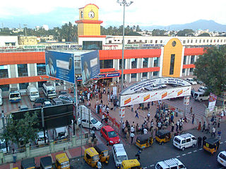
Coimbatore Junction, also known as Coimbatore Main Junction, is the primary railway station serving Coimbatore city.

The Velliangiri Mountains, a part of the Nilgiri Biosphere Reserve, are situated at the Western Ghats border of Coimbatore district, Tamil Nadu bordering Palakkad District, Kerala. Known as the "Sapthagiri, 7 Hills - Seven Mountains", these mountains are held and revered on par with spiritually most powerful place on the planet - Mount Kailash, the legendary abode of Lord Shiva. On the top of the Velliangiri Mountains, Shiva is worshipped as Swayambhu, one who is self-created and in this form, he graces the devotees.
This is a list of areas and neighbourhoods in Coimbatore by region. The city is divided on the basis of composition into four major parts: North, Central, South and East. Coimbatore east and its surrounding region is primarily a textile and industrial hub. Central Coimbatore is the commercial heart of the city. Coimbatore, is surrounded by the mountains on the west, and the reserve forests on the northern side. The entire western and northern part of the district borders the Western Ghats with the Nilgiri biosphere. A western pass to Kerala, popularly referred to as the Palghat Gap provides its boundary with the metropolitan area limits.

The Coimbatore–Shoranur line connects Coimbatore in the Indian state of Tamil Nadu and Shoranur in Kerala. There is a branch line Pothanur–Coimbatore–Mettupalayam and Mettupalayam to Udhagamandalam via Nilgiri Mountain Railway. This network links the railway network in Kerala to the network in Tamil Nadu via the Palakkad Gap.
The Coimbatore–Chamrajnagar line is a proposed railway line from Coimbatore (Tamilnadu) to Chamrajnagar (Karnataka). It is a part of Southern Railway zone of Indian Railways. This line upon construction will improve rail connectivity of western Tamilnadu with Karnataka.This line would give direct rail connectivity between coimbatore and mysore and will reduce the travel distance from Coimbatore to Mysore and Bangalore.It will also connect Tamilnadu with southern districts of Karnataka.

