
Erode District is one of the 38 districts in the state of Tamil Nadu in India. It was the largest district by area in the state before the formation of Tirupur District in 2009. The headquarters of the district is Erode. It is divided into two revenue divisions, Erode and Gobichettipalayam, and is further subdivided into 10 taluks. Erode District was a part of Coimbatore District before its division into two on 17 September 1979. It covers an area of 5,722 square kilometres (2,209 sq mi), and as of 2011, had a population of 2,251,744.

The Nilgiris district is one of the 38 districts in the southern Indian state of Tamil Nadu. Nilgiri is the name given to a range of mountains spread across the borders among the states of Tamil Nadu, Karnataka and Kerala. The Nilgiri Hills are part of a larger mountain chain known as the Western Ghats. Their highest point is the mountain of Doddabetta, height 2,637 m. The district is contained mainly within the Nilgiri Mountains range. The administrative headquarters is located at Ooty. The district is bounded by Coimbatore to the south, Erode to the east, and Chamarajnagar district of Karnataka and Wayanad district of Kerala to the north. As it is located at the junction of three states, namely, Tamil Nadu, Kerala, and Karnataka, significant Malayali and Kannadiga populations reside in the district. Nilgiris district is known for natural mines of Gold, which is also seen in the other parts of Nilgiri Biosphere Reserve extended in the neighbouring states of Karnataka and Kerala too.

Sathyamangalam is a town and municipality in Erode district in the Indian state of Tamil Nadu. It lies on the banks of the Bhavani river, a tributary of the Cauvery in the foothills of the Western Ghats and is the headquarters of Sathyamangalam taluk. It is about 65 km from Erode, 58 km from Tiruppur and 65 km from Coimbatore. As of 2011, the town had a population of 37,816.

Erode, is a city in the Indian state of Tamil Nadu. It is located on the banks of the Kaveri river and is surrounded by the Western Ghats. Erode is the seventh largest urban agglomeration in Tamil Nadu. It is the administrative capital of Erode district and is administered by the Erode Municipal Corporation which was established in 2008.

Gobichettipalayam is a town and municipality in Erode district of the Indian state of Tamil Nadu. It is the administrative headquarters of Gobichettipalayam taluk. It is situated at the center of the South Indian Peninsula at 213 metres (699 ft) above sea level, surrounded by Western Ghats. It is located 35 kilometres (22 mi) from the district headquarters Erode, 44 kilometres (27 mi) from Tiruppur and 80 kilometres (50 mi) from Coimbatore. Agriculture and textile industries contribute majorly to the economy of the town.

Bhavani is an interstate Indian river which flows through Indian states of Kerala and Tamil Nadu, India. It originates from the Western Ghats and is one among the three rivers of Kerala which flows in eastward direction.

Coimbatore district is one of the 38 districts in the state of Tamil Nadu in India. Coimbatore is the administrative headquarters of the district. It is one of the most industrialized districts and a major textile, industrial, commercial, educational, information technology, healthcare and manufacturing hub of Tamil Nadu. The region is bounded by Tiruppur district in the east, Nilgiris district in the north, Erode district in the northeast, Palakkad district, Idukki district and small parts of Thrissur district and Ernakulam district of neighboring state of Kerala in the west and south respectively. As of 2011, Coimbatore district had a population of 3,458,045 with a sex ratio of 1,000 and literacy rate of 84%.
Mettupalayam is a municipality town and taluk headquarters of Mettupalayam Taluk in the Coimbatore district of the Indian state of Tamil Nadu, a suburb of Coimbatore. It is the third largest town in the Coimbatore district after Coimbatore and Pollachi. It's located to the North of the Coimbatore city on the way to Ooty in the foothills of Nilgiri hills. As of 2011, the town had a population of 66,595. Mettupalayam railway station is the starting point of Nilgiri Mountain Railway and it operates the only rack railway in India connecting Ooty and Mettupalayam.
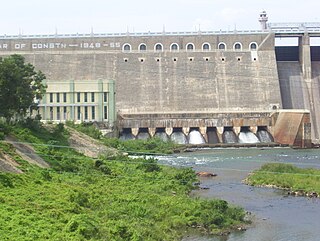
Bhavanisagar Dam or Lower Bhavani Dam, is located in Erode district, Tamil Nadu, India. The dam is constructed on the Bhavani river. It is one of the world's largest earthen dams. The dam is situated some 16 km (9.9 mi) west of Sathyamangalam, is 17 km North of Punjai Puliampatti, is 35 km (22 mi) from Gobichettipalayam and is 36 km (22 mi) north-east to Mettupalayam.
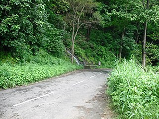
Many Ghat Roads can be found in the Nilgiris District of Tamil Nadu, Southern India. Nearly all of the district is located in the Nilgiri Hills, part of the Western Ghats mountains. This area borders the states of Karnataka and Kerala. The hills consequently can be reached by road from three states. Most of these Ghat Roads go through heavily forested mountains and contain a number of sharp hair-pin bends.
Aravenu is a very small township near Kotagiri of The Nilgiris District, Tamil Nadu, India. The population is largely Badaga and Tamil. It is the headquarters of the Jakanarai panchayat.

Burliar is a Panchayat village in Coonoor Taluk of The Nilgiris District, Tamil Nadu, India. Situated on the ghat road from Mettupalayam to Coonoor, Burliar is a popular rest stop with several small shops and restaurants. It has a government horticulture farm that was started in 1871.

The Nilgiri Express is a night express train service operating between Chennai Central and Mettupalayam, Coimbatore in Tamil Nadu, India. It is operated by Indian Railways.
Punjai Puliampatti is a municipality in the Erode district of Tamil Nadu, India.

Bannari is a small village located at a distance of 12 km from Sathyamangalam town and 35 km from Gobichettipalayam town in Erode District and 62 km from Tiruppur city and 82 km from Coimbatore city on Coimbatore-Bangalore NH 209 and it is close to Tamil Nadu and Karnataka border (20 km).
Erode city being the headquarters of Erode district, in Tamil Nadu, India, has an extensive road and rail transport network in all radial directions, as it lies landlocked.

Sathyamangalam Tiger Reserve is a protected area and tiger reserve located along the area straddling both the Western Ghats and Eastern Ghats in the Erode District of the Indian state of Tamil Nadu. The Sathyamangalam Forest Division is part of the Bramhagiri-Nilgiris-Eastern Ghats Elephant Reserve notified in 2003. In 2008, part of the Sathyamangalam Forest Division was declared as a wildlife sanctuary and enlarged in 2011, it covers a forest area of 1,411.6 km2 (545.0 sq mi). It is the largest wildlife sanctuary in Tamil Nadu. In 2013, an area of 1,408.6 km2 (543.9 sq mi) of the erstwhile sanctuary was notified as a tiger reserve. It was the fourth tiger reserve established in Tamil Nadu as a part of Project Tiger and is the third largest in the state.
Tamil Nadu, a state in South India, has a developed, dense, and modern transportation infrastructure, encompassing both public and private transport. Its capital city Chennai is well-connected by land, sea, and air and serves as a major hub for entry into South India.
Tamil Nadu State Highway 81 (SH-81) is a State Highway maintained by the Highways Department of Government of Tamil Nadu. It connects Gobichettipalayam with Dharapuram in the western part of Tamil Nadu.
The Coimbatore–Chamrajnagar line is a proposed railway line from Coimbatore in Tamil Nadu to Chamrajnagar in Karnataka. It is a part of the Southern Railway zone of the Indian Railways. Upon construction, this line would connect Western Tamil Nadu with Karnataka. The line would give direct rail connectivity between Coimbatore and Mysore and would reduce the travel distance from Coimbatore to Mysore and Bangalore. It would also connect Tamil Nadu with the Southern districts of Karnataka.


