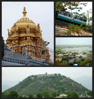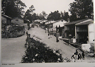
Kodaikanal is a hill station which is located in Dindigul district in the state of Tamil Nadu, India. Its name in the Tamil language means "The Gift of the Forest". Kodaikanal is referred to as the "Princess of Hill stations" and has a long history as a retreat and tourist destination.

Dindigul, also spelt Thindukkal, is a city in the Indian state of Tamil Nadu. It is the administrative headquarters of the Dindigul district. Dindigul is located 420 km (260 mi) southwest from the state capital, Chennai, 100 km (62 mi) away from Tiruchirappalli, 66 km (41 mi) away from Madurai and 72 km away from the Tex City of Karur. The city is known for its locks and biryani. Parts of Dindigul Districts like Palani, Oddanchatram, Vedasandur, Nilakottai, Kodaikanal, Natham, Athoor.

The Mumbai–Pune Expressway is India's first 6-lane wide concrete, access-controlled tolled expressway. It spans a distance of 94.5 km connecting Mumbai, the capital of Maharashtra state and the financial capital of India, with Pune, the cultural and educational capital of Maharashtra. The expressway, which was fully operationalized in 2002, introduced new levels of speed and safety in automobile transportation to Indian roads. It is one of India's busiest roads.

The Palani Hills are a mountain range in the southern Indian states of Kerala and Tamil Nadu. The Palani Hills are an eastward extension of the Western Ghats ranges, which run parallel to the west coast of India. The Palani Hills adjoin the high Anamalai range (Kerala) on the west, and extend east into the plains of Tamil Nadu, covering an area of 2,068 square kilometres (798 sq mi). The highest part of the range is in the southwest, and reaches 1,800-2,500 metres elevation; the eastern extension of the range is made up of hills 1,000-1,500 m (3,281-4,921 ft) high.

Palani (Tamil: [paɻani] or Palnias in British records, is a town and a taluk headquarters in Dindigul district of the western part of Tamil Nadu state in India. It is located about 106 kilometres south-east of Coimbatore and 122 kilometres north-west of Madurai, 67 kilometres from Kodaikanal. The Palani Murugan Temple or Arulmigu Dhandayuthapani Swamy Temple, dedicated to Lord Murugan is situated on a hill overlooking the town. The temple is visited by more than 7 million pilgrims each year. As of 2011, the town had a population of 126,751 which makes it the second largest town in the district after Dindigul.

Pollachi is a town and a taluk headquarters in Coimbatore district, Tamil Nadu state, India. Located about 40 km (25 mi) to the south of Coimbatore, it is the second largest town in the district after Coimbatore. Pollachi is a popular Marketplace for jaggery, vegetables and cattle. As of 2011, the town had a population of 90,180.

Batlagundu is a town in Nilakottai block in Dindigul district in the Madurai Region state of Tamil Nadu, India. The name Vetrilaikkundru later transformed and changed to Vathalagundu. The town is the major gateway to Kodaikanal. Subramaniya Siva was a writer, Indian Freedom Fighter, and activist born in Batlagundu. Batlagundu is the fifth-largest town in the Dindigul district. The town is located in such a way connecting three main districts of South Tamil Nadu. Batlagundu has most of the voters in Nilakottai Constituency.
Devadanapatti is a panchayat town in Periyakulam Taluk, a part of the Theni district in the Madurai Region in the state of Tamil Nadu, India. It is located at the bottom of the Kodaikanal Hills.

Udumalai, also known as Udumalaipettai and Udumalpet, is a town in Tiruppur district in the Indian state of Tamil Nadu. Udumalaipettai is located 535 km south west from the state capital, Chennai and 72 km away from Coimbatore, the second largest city in the state.
Kodai road is a railway station in Tamil Nadu state, India, lying between Dindigul and Madurai at 10°10′45″N77°54′34″E. It is formally listed as Kodaikanal Road.

Ghat Roads are access routes into the mountainous Western and Eastern Ghats, mountain ranges of the Indian subcontinent. These roads are remarkable feats of engineering, and most were constructed during the British Raj. Ghat Roads were built to connect to the hill stations established in the mountains for residents to avoid summer heat. They generally served to connect coastal areas with the upper Deccan Plateau.

Top Station is a tourist destination located in Theni district of Tamil nadu. Top Station is notable as the historic transshipment location for Kannan Devan tea delivered there from Munnar and Madupatty by railway and then down by ropeway to Kottagudi. This area is popular for the rare Neelakurinji flowers. The Kurinjimala Sanctuary is nearby. Top Station is the western entrance to the planned Palani Hills National Park.
The Palani Hills Wildlife Sanctuary and National Park is a proposed protected area in Dindigul District, Tamil Nadu India. The park will be an upgrade and expansion of the 736.87 km2(PRO) Palani (Kodaikanal) Wildlife Sanctuary which was to be established in 2008. The park includes about 36% of the 2,068 square kilometres (798 sq mi) in the Palani Hills. The park is located between latitude 10°7'–10°28' N and longitude 77°16'–77°46' E. Central location is 1.5 kilometres (0.93 mi) east northeast of Silver Cascade Waterfall and 4 kilometres (2.5 mi) E X NE of Kodaikanal Lake.

Vilpatti is a Panchayat in Kodaikanal Taluk of Dindigul district, Tamil Nadu state, South India. It is composed of the main village of Vilpatti and 11 hamlets. Main Vilpatti village is 9 km North of Kodaikanal town, but hamlets within its administration extend to the Palani ghat road. It is an agricultural area with the primary crops of potatoes, carrot, coffee and bananas.

Kodaikanal Lake, also known as Kodai Lake, is a manmade lake located in the Kodaikanal city in Dindigul district in Tamil Nadu, India. Sir Vere Henry Levinge, the then Collector of Madurai, was instrumental in creating the lake in 1863, amidst the Kodaikanal town which was developed by the British and early missionaries from USA. The lake is said to be Kodaikanal's most popular geographic landmark and tourist attraction.

Kodaikanal is a city and a Taluk division of Dindigul district in the state of Tamil Nadu, India.

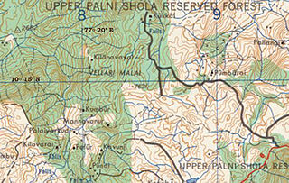
Kookal is a Panchayat village of terrace farmers at the far western end of the Palani Hills in Kodaikanal block of Dindigul district, Tamil Nadu state, South India. It is 40 kilometres (25 mi) from Kodaikanal at: 10°17′9″N77°21′48″E. Elevation is 1,890 metres (6,200 ft). Kookal is notable for the high biodiversity of the area.

Kavunji is a Panchayat village of terrace farmers at the far western end of the Western Ghats in Kodaikanal block of Dindigul district, Tamil Nadu state, South India, Pincode 624103. It is 35 kilometres (22 mi) from Kodaikanal at: 10°12′26″N77°20′25″E. Elevation is 1,920 metres (6,300 ft). Kavunji is notable as a vegetable farming area.

The Kodaikanal–Munnar Road was located in Dindigul District and Theni District of Tamil Nadu and Idukki district of Kerala in South India. It covers 81 kilometers (50 mi) from Kodaikanal to Munnar. The road was improved by the British in 1942 as an evacuation route in preparation for a possible Japanese invasion of South India. With a maximum elevation of 2,480 meters (8,140 ft) just south of Vandaravu Peak, it was among the highest roads in India, south of the Himalayas, prior to its closure in 1990.

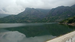
The Manjalar Dam is a dam across the Manjalar River in the Indian state of Tamil Nadu.


