
Erode, is a city in the Indian state of Tamil Nadu. It is located on the banks of the Kaveri river and is surrounded by the Western Ghats. Erode is the seventh largest urban agglomeration in Tamil Nadu. It is the administrative capital of Erode district and is administered by the Erode Municipal Corporation which was established in 2008.

Palakkad Gap or Palghat Gap is a low mountain pass in the Western Ghats between Coimbatore in the Indian state of Tamil Nadu and Palakkad in the state of Kerala. It has an average elevation of 140 metres (460 ft) with a width of 24–30 kilometres (15–19 mi). The pass is located between the Nilgiri Hills to the north and Anaimalai Hills to the south.
Chennimalai is a town in Erode district, Tamil Nadu, India. It is situated away from Erode of about 28kms., Chenni which means Chief and Malai means Hill. It is popularly known as the 'Handloom Town'.

Dharapuram is a town situated along the banks of Amaravati River in Tiruppur district in the Indian state of Tamil Nadu. Dharapuram is one of the oldest towns in South India and was the capital of Kongu Nadu under the Cheras, Western Ganga Dynasty and later Kongu Cholas, at which time it was known as Viradapuram. Amaravathi River flows through the town. As of 2011, the town had a population of 67,007. The city houses famous temples including Agatheeswarar Temple, Kaadu Hanumanthasamy temple and many others.
Kangeyam is a historical town and municipality in Kangeyam Taluk of Tiruppur district in the Indian state of Tamil Nadu. It is situated on National Highway 81. Kangeyam is an economic center in Tamil Nadu. The main commercial interests of the municipality are rice hulling, coconut oil extraction, ghee production, and groundnut cultivation. The town is located 28 km from the district headquarters at Tiruppur, 45 km from the city of Erode, 70 km from the industrial town of Coimbatore,30 km from the town of Dharapuram, 55 km from the city of Karur, 140 km from the Ancient city of Trichy and 441 km from the state capital Chennai.
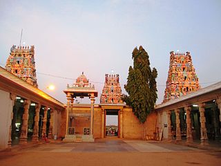
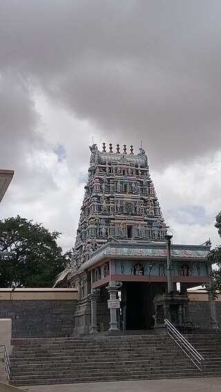
Kodumudi is a panchayat town and taluk headquarters of Kodumudi taluk in Erode district at state of Tamil Nadu, India. Kodumudi has an average elevation of 144 metres (472 feet). Also Kodumudi is an tourism spot. The holy Kaveri river and Magudeswarar temple in Kodumudi attracts thousands of pilgrims daily across South India.

Muthur is a panchayat town in Vellakovil block which comes under Kangeyam taluk in Tirupur district, Tamil Nadu, India.
Vellakovil is a municipal town in Kangeyam taluk of Tirupur District, in the Indian state of Tamil Nadu. It is located on National Highway 81 between Trichy and Coimbatore. The town is spread in an area of 64.75 km2. As of 2011, the town had a population of 40,359. Kannapuram village located near to this town is famous for Kangeyam breed cattle market that happens on every year during Mariyamman temple festival in the month of April. It is an industrialized town with traditional agriculture being the occupation for most of the people. It holds lot of Power looms weaving bedsheets, floor mats and cotton materials being exported to foreign countries via exporters present in Karur.
Tiruppur District is one of the 38 districts of the Indian state of Tamil Nadu, formed in 22 February 2009. Dharapuram was the largest taluk by area in the district. The district is well-developed and industrialized. The Tiruppur banian industry, the cotton market, Kangeyam bull and Uthukkuli butter, among other things, provide for a vibrant economy. The city of Tiruppur is the administrative headquarters for the district. As of 2011, the district had a population of 2,479,052 with a sex-ratio of 989 females for every 1,000 males.
Dharapuram taluk is a taluk in Tirupur district of the Indian state of Tamil Nadu. The headquarters is the town of Dharapuram. Dharapuram taluk previously included what is now Kangeyam taluk.
Kangeyam taluk is a taluk of Tirupur district of the Indian state of Tamil Nadu. The headquarters of the taluk is the town of Kangeyam. Kangeyam Taluk Formed From Bifurcation of Dharapuram taluk.
Erode city being the headquarters of Erode district, in Tamil Nadu, India, has an extensive road and rail transport network in all radial directions, as it lies landlocked.
Dharapuram division or Dharapuram sub-district is a revenue division in the Tiruppur district of Tamil Nadu, India. It is One Of The Three Revenue Divisions of Tiruppur district Other Two are Tiruppur and Udumalaipettai block. Dharapuram division Includes Two Talukas Dharapuram, Kangeyam and five panchayat unions, Dharapuram, Kangeyam, Vellakoil, Mulanur, Kundadam. Dharapuram Division has an area of 2057 km2, which is 40% of the total area of Tiruppur District and 1.58% of TamilNadu. Dharapuram Division has a population of 5,29,654.
Tamil Nadu State Highway 81 (SH-81) is a State Highway maintained by the Highways Department of Government of Tamil Nadu. It connects Gobichettipalayam with Dharapuram in the western part of Tamil Nadu.
State Highway 96 runs in Erode district and Tiruppur district of Tamil Nadu, India. It connects the towns of Erode and Kangeyam via Perundurai.
Pongalur is a small town located in Palladam Taluk of Tiruppur district in Tamil Nadu, India. It is located along the Coimbatore - Trichy National highway and headquarters the Pongalur block. It is located 10 km from Palladam, 22 km from Kangeyam, 35 km from Dharapuram and 20 km from district headquarter Tiruppur and 50 km from Coimbatore. It is known for its famous Varadharaja perumal Temple.

Uthiyur is a small town in Kangeyam taluk of Tiruppur district in south Indian state of Tamil Nadu.
The Erode–Kangeyam-Dharapuram-Palani line is a proposed railway line from Erode Junction (via) Kangeyam,Dharapuram to Palani in the state of Tamil Nadu. It is a part of Southern Railway zone of Indian Railways. This line upon construction will improve rail connectivity of the Pilgrimage center with Chennai and other states of the country. It was a revised version of the original pre-independence proposal by the British.

Kundadam is a small town located in Dharapuram taluk of Tiruppur district in Indian state of Tamil Nadu. It is the headquarters of the Kundadam Panchayat Union in Tiruppur district. It is located 16Km away from Dharapuram in Coimbatore-Dharapuram highway. In the classical Tamil texts, this town is named as Kundrai, Kundrapuram, Kundrai Managar and Kundridam. The town houses famous temples including Varatharājaperumāl Temple, Kala Bairavar Temple, Kongu Vatuganādha Swāmy Temple, Koṅgar Chinnamman Temple and Vadivudaimangai Udanurai Konguvidangkisuvarar Temple.

Koduvai(Koduvāi) is a small town in Tiruppur District in Tamil Nadu, India. It comes under Pongalur block and Tiruppur South taluk. It is located 26 km away from Dharapuram and 25 km from Tiruppur in Tiruppur-Dharapuram highway. The town houses famous temples including NageswaraSami Temple and PeriyaPerumal Temple.
