
Erode is a city in the Indian state of Tamil Nadu. Erode is the seventh largest urban agglomeration in the state, after Chennai, Coimbatore, Madurai, Tiruchirapalli, Tiruppur and Salem. It is also the administrative headquarters of the Erode district. Administered by a city municipal corporation since 2008, Erode is a part of Erode Lok Sabha constituency that elects its member of parliament. Located on the banks of River Kaveri, it is situated centrally on South Indian Peninsula, about 400 kilometres (249 mi) southwest of its state capital Chennai, 250 kilometres (155 mi) south of Bengaluru, 100 kilometres (62 mi) east of Coimbatore and 275 kilometres (171 mi) east of Kochi. Erode is an agricultural, textile and a BPO hub and among the largest producers of turmeric, hand-loom and knitwear, and food products.
Perundurai is a Special Grade Town Panchayat in Erode district in the Indian state of Tamil Nadu. Perundurai is the only special grade town panchayat among 42 in the district. Perundurai has developed as the industrial center with SIPCOT Industrial Estate and SEZ Complex. It is the Asia's Second largest SIPCOT.
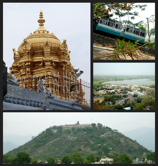
Palani (Tamil: [paɻani] or Palnias in British records, is a town and a taluk headquarters in Dindigul district of the western part of Tamil Nadu state in India. It is located about 106 kilometres south-east of Coimbatore and 122 kilometres north-west of Madurai, 67 kilometres from Kodaikanal and 72 kilometres from vellakovil. The Palani Murugan Temple or Arulmigu Dhandayuthapani Swamy Temple, dedicated to Lord Murugan is situated on a hill overlooking the town. The temple is visited by more than 7 million pilgrims each year. As of 2011, the town had a population of 126,751 which makes it the second largest town in the district after Dindigul.
Arachalur is a panchayat town in Erode district in the state of Tamil Nadu, India. It is situated 22 kilometres from Erode and an important junction on SH 37 en route to Dharapuram and other important small towns like Kodumudi and Chennimalai.

Aravakurichi is a panchayat town and a Taluk headquarters in Karur district in the state of Tamil Nadu, India. Aravakurichi is well known in Tamil Nadu as a major market for Moringa oleifera vegetable. Aravakurichi is the headquarters of Aravakurichi taluk which consists of 40 revenue Villages.
Chennimalai is a town in Erode district, Tamil Nadu, India. It is popularly known as the 'Handloom Town'.

Dharapuram is a town situated along the banks of Amaravati River in Tiruppur district in the Indian state of Tamil Nadu. Dharapuram is one of the oldest towns in South India and was the capital of Kongu Nadu under the Cheras, Western Ganga Dynasty and later Kongu Cholas, at which time it was known as Viradapuram. Amaravathi River flows through the town. As of 2011, the town had a population of 67,007. The city houses famous temples including Agatheeswarar Temple, Kaadu Hanumanthasamy temple and many others.
Edappadi is a municipality in Salem district in the state of Tamil Nadu, India. Edappadi was once known for its thriving power loom industry. The economy is diversified by agriculture, heavy truck transport, granite, entertainment and foundries.

Oddanchatram is a town in Dindigul district in the Indian state of Tamil Nadu. Oddanchatram is a region in the southwest of Tamil Nadu. The Town was carved out of Madurai District in 1985. Oddanchatram is also famous for vegetable and cattle market. As of 2011, the town had a population of 30,064. It is known as vegetable city of Tamil Nadu. Oddanchatram vegetable market is the largest supplying of vegetables in Tamilnadu and Kerala. Agriculture is the major economic support for the town.
Karumathampatti is a Municipality in the Coimbatore district in the state of Tamil Nadu, India. It is one of the most developing suburb in Coimbatore about 25 km away from the city centre. It is situated in between NH544 which connects the city of Coimbatore with Salem – Erode – Tirupur and also in between the State Highway 165 connects Annur – Kamanaikenpalayam. Nearby places are Somanur-3 km, Avinashi-10 km, Tirupur-20 km, Sulur-15 km, Annur-16 km. Coimbatore -27,Mettupalayam-38,Palladam-19. Karumathampatti lies near the junction of two major roads, NH544(Coimbatore – Salem) and Karumathampatti – Annur road.
Kunnathur is a panchayat town in Tirupur district in the Indian state of Tamil Nadu. It was previously under the jurisdiction of the Erode district. However kunnathur is in tiruppur district, legislative assembly consistency for kunnathur is Perundurai which is in Erode district.
Madathukulam is Border to Dindigul District in Tirupur district in the Indian state of Tamil Nadu.

Muthur is a panchayat town in Kangeyam taluk in Tirupur district, Tamil Nadu, India.

Udumalai, also known as Udumalaipettai and Udumalpet, is a town in Tiruppur district in the Indian state of Tamil Nadu. Udumalaipettai is located 535 km south west from the state capital, Chennai and 72 km away from Coimbatore, the second largest city in the state.
Vanavasi is a Town Panchayat in Mettur Taluka, Salem District, in the Indian state of Tamil Nadu.
Paramathi Velur, a town in Paramathi-Velur taluk, Namakkal District, Tamil Nadu, India is situated just off the Srinagar - Kanyakumari National Highway 44 (India). This town is also called as Paramathi Velur, with STD Code 04268 & Postal code 638182.

Vijayamangalam is a census town in Erode district in the Indian state of Tamil Nadu. It is located on National Highway 47 (NH-47) between Perundurai and Perumanallur.
Thirumalaigoundenvalasu is a village and a panchayat in the oddanchatram Taluk of Dindigul district in the South Indian state of Tamil Nadu.
' or K G Valasu' is a village in Erode district in the Indian state of Tamil Nadu located near to the northern banks of Noyyal River.

Uthiyur is a small town in Kangeyam taluk of Tiruppur district in south Indian state of Tamil Nadu.
