Nagapattinam district

Last updated

Nagapattinam district
Thirunagai8.JPG
Nagore Dargah1.JPG
Shrine velankanni,tamilnadu - panoramio (1).jpg
Thirupugalur20.JPG
Point calimere salt pans JEG7136.jpg
Nagapattinam in Tamil Nadu (India).svg
Location in Tamil Nadu
Coordinates: 10°46′1.2″N79°49′58.8″E / 10.767000°N 79.833000°E / 10.767000; 79.833000
CountryFlag of India.svg  India
State TamilNadu Logo.svg Tamil Nadu
Established18 October 1991
Founded by J. Jayalalithaa
Taluks Kilvelur, Nagapattinam, Thirukkuvalai, Vedaranyam
Government
  TypeMunicipality
   District Collector A. Arun Thamburaj, IAS
   Superintendent of Police G. Jawahar, IPS
Area
  Total1,397 km2 (539 sq mi)
  Rank36
Elevation
9 m (30 ft)
Population
 (2011)
  Total697,069
  Rank37
  Density498/km2 (1,290/sq mi)
Languages
  Official Tamil
Time zone UTC+5:30 (IST)
Telephone code04365
ISO 3166 code ISO 3166-2:IN
Vehicle registration TN-51 [1]
Lok Sabha constituency2
Vidhan Sabha constituency5
Website nagapattinam.nic.in

Nagapattinam district is one of the 38 districts of Tamil Nadu state in southern India. Nagapattinam district was carved out by bifurcating the erstwhile composite Thanjavur district on 19 October 1991. The town of Nagapattinam is the district headquarters.

Contents

Until Mayiladuthurai district was created out of it on 24 March 2020, Nagapattinam was the only discontiguous district in Tamil Nadu.

Etymology

Nagapattinam is derived from Nagar, referring to people, and pattinam referring to town. In Tamil Pattinam and paakkam depicts coastal towns. [2] [3] The town was also called Cholakula Vallipattinam during the Chola period, when it was one of the important ports. Ptolemy refers to Nagapattinam as Nikam and mentions it as one of the most important trade centres of the ancient Tamil country. [2] This view is doubtful as there is no contemporary evidence to prove the existence of the town as a metropolis in the name of "Nikama" or "Nikam". [4] Nagapattinam was referred to by early writers and the Portuguese as "the city of Coromandel". [2] The place is revered in Nalayira Divya Prabandham as Nagai in the 5th to 9th century CE [5] Vaishnava canon, by Alvars.[ citation needed ] It is considered one of the important temples visited by Thirumangai Alvar. [6] Appar and Tirugnanasambandar, the 7th-century saint poets refer to the city as Nagai in their verses in Tevaram. The town was originally called "Nagai"; the word Pattinam was attached during the Chola era when the town emerged as an important port. [7]

History

Nagapattinam district was an important region of the Chola kingdom. There are urn burials in and around the city from the Sangam period indicating some level of human habitation. [4] The neighbouring port, Kaveripoompattinam (modern day Poompuhar), was the capital of the Chola kingdom of the Sangam Age, referred to widely in Tamil scriptures like Paṭṭiṉappālai . [4]

The early works of Tevaram by the 7th-century poets Appar and Sambandar mention that the town had fortified walls, busy roads, buildings and a busy port. [8] The inscriptions from the Kayarohanswami temple indicate the construction was initiated during the reign of the Pallava king, Narasimha Pallava II (691 – 729 CE). [9] A Buddhist pagoda was built under Chinese influence by the Pallava king and town was frequented by Buddhist travellers. [9] In the 11th century CE, Chudamani Vihara, a Buddhist monastery was built by Javanese king Sri Vijaya Soolamanivarman with the patronage of Raja Raja Chola. [10] Nagapattinam was the prominent port of Cholas for trade and conquering gateway to the east.[ citation needed ]

In the early 16th century the Portuguese made commercial contacts with the town and established a commercial centre in 1554 CE. The Portuguese also conducted missionary enterprise in the town. [11] In 1658, the Dutch established an agreement with King Vijaya Nayakkar of Thanjavur on 5 January 1662. Ten villages were transferred from the Portuguese to the Dutch – Nagappattinam Port, Puthur, Muttam, Poruvalancheri, Anthanappettai, Karureppankadu, AzhingiMangalam, Sangamangalam, Thiruthinamangalam, Manjakollai, Nariyankudi. Ten Christian churches and a hospital were built by the Dutch. They also released coins with the name Nagappattinam engraved in Tamil letters. Under an agreement between the first Maratta King Egoji of Thanjavur and the Dutch, Naagappattinam and surrounding villages were handed over to the Dutch on 30 December 1676. In 1690, the capital of Dutch Coromandel moved from Pulicat to Nagapattinam. [11]

This town fell into the hands of the British in 1781 after the two naval battles between British and French fleets were fought off the coast of Negapatam, as it was then known: the first in 1758 as part of the Seven Years' War and the second in 1782 as part of the American Revolutionary War. The town was taken by the British from the Dutch in 1781 (who had been formally brought into the war in 1780). [12] When the Dutch and British reached a peace agreement in 1784, Nagapattinam was formally ceded to the British. 277 villages, with Nagore as the headquarters, were handed over to the East India Company.[ citation needed ]

From 1799 to 1845 CE Nagapttinam was the headquarters of Tanjore district. [2] Nagapattinam and Nagore were incorporated as a single municipality in 1866 CE. [2] The town remained one of the chief ports to the Madras Presidency. The port suffered decline after the inclusion of Tranquebar and Tuticorin.

The 2004 Indian Ocean earthquake was an undersea megathrust earthquake that occurred on 26 December 2004, with an epicentre off the west coast of Sumatra, Indonesia, triggering a series of devastating tsunamis along the coasts of most landmasses bordering the Indian Ocean. [13] Nagapattinam was one of the regions severely affected in Tamil Nadu, accounting for 6,064 off the 8,009 casualties in the state, [14] predominantly from the fishing community who resided close to the seashore. The damage impacted the fishing industry, as most of the boats were damaged by the inundation. [15] The immediate aftermath created a lull in tourism. [16]

Geography

The district shares borders with Tiruvarur district of Tamil Nadu and Karaikal district of the union territory Puducherry. The district of Nagapattinam lies on the shores of the Bay of Bengal between latitude 10.7906°N and Longitude 79.8428°E an area of 1,397 square kilometres (539 sq mi). [17] The District capital, Nagapattinam lies on the eastern coast, 350 kilometers down south of the State capital Chennai and of Tiruchirappalli. It has an average elevation of 9 metres (30 ft) above the mean sea level. [17] The district has a coastline of 187 kilometres (116 mi). [17]

Climate data for Nagapattinam, India
MonthJanFebMarAprMayJunJulAugSepOctNovDecYear
Average high °C (°F)30.85
(87.53)
32.67
(90.81)
36.83
(98.29)
38.72
(101.70)
40.2
(104.4)
38.1
(100.6)
37.07
(98.73)
36.54
(97.77)
37.02
(98.64)
33.67
(92.61)
29.66
(85.39)
29.13
(84.43)
40.2
(104.4)
Average low °C (°F)21.72
(71.10)
22.15
(71.87)
23.37
(74.07)
26.68
(80.02)
27.48
(81.46)
27.17
(80.91)
26.36
(79.45)
25.44
(77.79)
25.17
(77.31)
24.43
(75.97)
29.66
(85.39)
29.13
(84.43)
29.13
(84.43)
Average precipitation mm (inches)12.2
(0.48)
12.4
(0.49)
2
(0.1)
26.5
(1.04)
39.5
(1.56)
39
(1.5)
25
(1.0)
85
(3.3)
32.15
(1.27)
46
(1.8)
319.75
(12.59)
Source: [18]

Economy

In 2006 the Ministry of Panchayati Raj named Nagapattinam one of the country's 250 most backward districts (out of a total of 640). [19] It is one of the six districts in Tamil Nadu currently receiving funds from the Backward Regions Grant Fund Programme (BRGF). [19]

Demographics

Historical population
YearPop.±% p.a.
1901652,643    
1911688,101+0.53%
1921674,234−0.20%
1931693,484+0.28%
1941745,006+0.72%
1951863,674+1.49%
1961954,318+1.00%
19711,087,429+1.31%
19811,234,441+1.28%
19911,377,601+1.10%
20011,488,839+0.78%
20111,616,450+0.83%
source: [20]

According to the 2011 census, Nagapattinam district had a population of 698,094 with a sex-ratio of 1,025 females for every 1,000 males, much above the national average of 929. 26.94% of the population lived in urban areas. [21] A total of 165,245 were under the age of six, constituting 84,335 males and 80,910 females. Scheduled Castes and Scheduled Tribes accounted for 30.51% and 0.23% of the population respectively. [22] The average literacy of the district was 75.04%, compared to the national average of 72.99%. [21] The district had a total of 413,837 households. There were a total of 671,994 workers, comprising 54,329 cultivators, 216,353 main agricultural labourers, 7,925 in household industries, 207,721 other workers, 185,666 marginal workers, 13,153 marginal cultivators, 128,704 marginal agricultural labourers, 3,630 marginal workers in household industries and 40,179 other marginal workers. [23] The birth rate on a scale of one thousand in rural areas of the district is 19.9, urban is 17.8 and the combined birth rate is 18.85. [17] The death rate on a scale of one thousand in rural areas of the district is 8.2, urban is 6.7 and the combined rate is 7.45. [17] Tamil is the predominant language, spoken by 99.56% of the population. [24]

Religions in Nagapattinam district (2011) [25]
ReligionPercent
Hinduism
88.13%
Islam
8.95%
Christianity
2.70%
Other or not stated
0.22%

Politics

DistrictNo.ConstituencyNamePartyAllianceRemarks
Nagapattinam 163 Nagapattinam Aloor Shanavas Viduthalai Chiruthaigal Katchi INDIA
164 Kilvelur (SC) Nagai Maali (A) P. Mahalingam Communist Party of India (Marxist) INDIA
165 Vedaranyam O. S. Manian All India Anna Dravida Munnetra Kazhagam AIADMK

Education

There are a total of 891 elementary schools, 185 middle schools, 83 high schools and 79 higher secondary schools in the district. [17]

Administration

The Collector is the administrative head of each district and is the principle representative of the government for the district. The Collector's main responsibilities include revenue administration, Executive Magistracy, maintaining law and order, licensing and regulatory functions, disaster management, civil supplies, public distribution, social welfare, excise, transport, mining, labour laws, elections, legal affairs, census, general administration, treasury management and co-ordination with various departments of the state and central governments. The Collector is also the head of various committees formed at the district level for the various central and state government schemes. [26]

There are 32 districts in Tamil Nadu, each divided for revenue administration purposes into revenue divisions, which are further divided into Talukas. Each of these Talukas has a list of revenue villages and is headed by a Tahsildar. [27] Developmental administration of the district is carried out by Panchayat Unions (or Town Panchayats) in rural areas. These panchayat unions have a set of panchayat villages under them. In urban areas, the governance is done by municipal corporations, municipalities or town panchayats based on the size of the town; each of these has a set of wards. [27] The functions of the municipality are devolved into six departments: general administration/personnel, Engineering, Revenue, Public Health, Town Planning, and Information Technology (IT). [28] The municipalities are administered by a Municipal Commissioner, who is the executive head. [28] The legislative powers are vested in a body of elected members from each ward of the municipality. The legislative body is headed by an elected Chairperson assisted by a Deputy Chairperson. [29]

Nagapattinam District was formerly a part of Thanjavur District. The district boundary is shared by Tiruvarur, Karaikal, Tanjore and Cuddalore districts. Its population at the 2001 Census was nearly 1.5 million. The district has seven taluks, eleven administrative blocks, eight town panchayats, and four municipalities. [27] Five of the talukas are coastal, and all are named after their main towns, which are their administrative centres. From north to south, they are Nagapattinam, Kilvelur, Thirukkuvalai (non-coastal), and Vedaranyam. It is bordered on the east by the Bay of Bengal and on the south by the Palk Strait. On the coast between Tharamgambadi and Nagapattinam lies the small district of Karaikal, an enclave belonging administratively to the Puducherry Union Territory. This is the only district in Tamil Nadu to be formed out of two disjoint regions. The district headquarters, Nagapattinam, is located in the southern part which is less populated than the northern one.[ citation needed ]

Politics

Member of Parliament
Nagapattinam M. Selvarasu [30]
Members of Legislative Assembly
Nagapattinam Aloor Shanavas [31]
Kilvelur (SC) P. Mahalingam [32]
VedaranyamO. S. Maniyan

The district has two Lok Sabha constituencies, namely Nagapattinam Lok Sabha constituency . The current Member of Parliament from the Nagapattinam constituency is M. Selvarasu from the CPI. [30]

There are a total of three legislative assembly constituencies in the district, namely, Kilvelur, Nagapattinam and Vedaranyam. [33] Out of these Kilvelu constituencies is reserved for Scheduled Caste (SC). [33]

Culture and tourism

Tourism plays a key economic role for the town even though fishing is the major occupation.

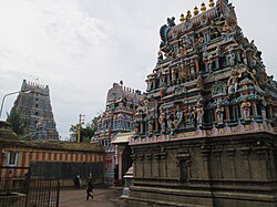
Kayarohanaswami Temple, a Hindu temple dedicated to Shiva, is located in Nagapattinam. The temple has been in existence from the 6th century CE and has been revered by the verses of Tevaram, the 7th–8th century Saiva canonical work by Appar, Sambandar and Sundarar. [34] The temple is one of the seven temples of the Thyagaraja cult, classified as Saptha Vidangam, where the deity Thyagaraja is believed to portray different dance styles. [35] The temple is also known for the shrine of Neelayadakshi, the consort of Kayarohanaswami. [34]

Kayarohanaswami Temple - one of the oldest temples in the town Kayarohanaswami Temple.jpg
Kayarohanaswami Temple – one of the oldest temples in the town

Soundararajaperumal Temple is a Hindu temple in Nagapattinam dedicated to Vishnu. It is one of the Divya Desams, the 108 temples of Vishnu revered in Nalayira Divya Prabandham by the Tirumangai Alvar, one of the 12 poet saints called Alwars of the 6th–9th century. [34] The other prominent Hindu temples in the district are Sikkal Singaravelan Temple at Sikkal, Vedaranyeswarar Temple at Vedaranyam, Ettukudi Murugan Temple and Koothanur Maha Saraswathi Temple. [36]

Nagore Durgah, built in the 16th century is one of the major landmarks of the town Nakur tharka.jpg
Nagore Durgah, built in the 16th century is one of the major landmarks of the town

Nagore Durgha, a 16th-century minaret located in Nagore, is an important pilgrimage centre of the town. The Kanduri festival is a 14-day event celebrated for the annual urs(anniversary) of the saint Hajrath Shahul Hamid (1490–1579 CE), for whom the minaret was built. [37] The festival is celebrated in commemoration of the anniversary of the saint's death, and pilgrims from various religions participate in the rituals and rites. The festival is also seen as a sacred exchange between Hindus and Muslims expressing solidarity of mixed faith in the region. [38] It is believed that 60 percent of the shrines were built by Hindus and historically the minaret has many domestic and international visitors. [39] There are three other prominent mosques; one near Nagai Pudhur Road, one near the new bus stand and another at Moolakadai Street. [34]

Velankanni is a pilgrimage centre located 10 km (6.2 mi) from Nagapattinam. The town is known for the Basilica of Our Lady of Good Health, a Roman Catholic church built during the 17th century. Pilgrimage to the basilica is common during September when people of many faiths, especially Hindus, Muslims and Christians of all denominations visit the basilica. [36]

See also

Notes

  1. www.tn.gov.in
  2. 1 2 3 4 5 W. 2002, p. 161.
  3. Tamil Nadu Urban Infrastructure Financial Services Limited 2008, p. 5.
  4. 1 2 3 Kulke, Kesavapany & Sakhuja 2009, pp. 102–104.
  5. Srinivasa Chari, S. M. (25 September 1997). Philosophy and Theistic Mysticism of the Āl̲vārs. Motilal Banarsidass Publ. ISBN   9788120813427.
  6. Ayyar, P. V. Jagadisa (1982). South Indian Shrines: Illustrated. New Delhi: Asian Educational Services. p. 534. ISBN   9788120601512.
  7. Kulke, Kesavapany & Sakhuja 2009, pp. 104–107.
  8. Kulke, Kesavapany & Sakhuja 2009, pp. 107–108.
  9. 1 2 Kulke, Kesavapany & Sakhuja 2009, pp. 108–119.
  10. Kulke, Kesavapany & Sakhuja 2009, p. 67.
  11. 1 2 W. 2002, p. 139.
  12. W. 2002, p. 136.
  13. Karan & Subbiah 2011, p. 70.
  14. Karan & Subbiah 2011, p. 77.
  15. Karan & Subbiah 2011, p. 227.
  16. Karan & Subbiah 2011, p. 231.
  17. 1 2 3 4 5 6 District profile 2011.
  18. Dr. R.K. 2007, p. 19.
  19. 1 2 Ministry of Panchayati Raj (8 September 2009). "A Note on the Backward Regions Grant Fund Programme" (PDF). National Institute of Rural Development. Archived from the original (PDF) on 5 April 2012. Retrieved 27 September 2011.
  20. Decadal Variation In Population Since 1901
  21. 1 2 "Census Info 2011 Final population totals". Office of The Registrar General and Census Commissioner, Ministry of Home Affairs, Government of India. 2013. Retrieved 26 January 2014.
  22. District census 2011 - Nagapattinam
  23. "Census Info 2011 Final population totals – Nagapattinam district". Office of The Registrar General and Census Commissioner, Ministry of Home Affairs, Government of India. 2013. Retrieved 26 January 2014.
  24. "Table C-16 Population by Mother Tongue: Tamil Nadu". Census of India . Registrar General and Census Commissioner of India.
  25. "Table C-01 Population by Religion: Tamil Nadu". censusindia.gov.in. Registrar General and Census Commissioner of India. 2011.
  26. Second Administrative Reforms Commission Fifteenth report (PDF) (Report). State and District administration, Ministry of Personnel, Public Grievances & Pensions, Department of Administrative Reforms and Public Grievances, Government of India. April 2009. pp. 68–71.
  27. 1 2 3 Districts of Tamil Nadu 2012.
  28. 1 2 Commissionerate of Municipal Administration 2006.
  29. Economic and political weekly 1995.
  30. 1 2 MP of Nagapattinam 2009.
  31. List of MLAs 2021.
  32. List of MLAs 2011.
  33. 1 2 List of Assembly constituencies 2010.
  34. 1 2 3 4 Various 2007, p. 61.
  35. The Hindu& 16 July 2010.
  36. 1 2 Tamil Nadu Urban Infrastructure Financial Services Limited 2008, pp. 14–15.
  37. Hunter 1908, p. 3.
  38. Werbner & Basu 1998, pp. 61–62.
  39. Visweswaran 2011, pp. 33–34.

Related Research Articles

<span class="mw-page-title-main">Thanjavur</span> Historical city in Tamil Nadu, India

Thanjavur, also known as Thanjai, previously known as Tanjore, is a city in Tamil Nadu. Thanjavur is the 11th biggest city in Tamil Nadu. Thanjavur is an important center of South Indian religion, art, and architecture. Most of the Great Living Chola Temples, which are UNESCO World Heritage Monuments, are located in and around Thanjavur. The foremost among these, the Brihadeeswara Temple, built by the Chola emperor Rajaraja I, is located in the centre of the city. Thanjavur is also home to Tanjore painting, a painting style unique to the region. Thanjavur is the headquarters of the Thanjavur District. The city is an important agricultural centre located in the Kaveri Delta and is known as the Rice bowl of Tamil Nadu. Thanjavur is administered by a municipal corporation covering an area of 128.02 km2 (49.43 sq mi) and had a population of 290,720 in 2011. Roadways are the major means of transportation, while the city also has rail connectivity. The nearest airport is Tiruchirapalli International Airport, located 59.6 km (37.0 mi) away from the city. The nearest seaport is Karaikal, which is 94 km (58 mi) away from Thanjavur. The city first rose to prominence during the reign of the Cholas when it served as the capital of the empire. After the fall of the Cholas, the city was ruled by various dynasties such as the Mutharaiyar dynasty, the Pandyas, the Vijayanagar Empire, the Madurai Nayaks, the Thanjavur Nayaks, the Thanjavur Marathas and the British Empire. It has been a part of independent India since 1947.

<span class="mw-page-title-main">Mayiladuthurai</span> Town in Tamil Nadu, India

Mayiladuthurai is a town and district headquarter of Mayiladuthurai district in Tamil Nadu, India. The town is located at a distance of 256 km (159 mi) from the state capital, Chennai.

<span class="mw-page-title-main">Nagapattinam</span> Town in Tamil Nadu

Nagapattinam is a town in the Indian state of Tamil Nadu and the administrative headquarters of Nagapattinam district. The town came to prominence during the period of Medieval Cholas and served as their important port for commerce and east-bound naval expeditions. The Chudamani Vihara in Nagapattinam constructed by the Srivijayan king Sri Mara Vijayattungavarman of the Sailendra dynasty with the help of Rajaraja Chola I was an important Buddhist structure in those times. Nagapattinam was settled by the Portuguese and, later, the Dutch under whom it served as the capital of Dutch Coromandel from 1660 to 1781. In November 1781, the town was conquered by the British East India Company. It served as the capital of Tanjore district from 1799 to 1845 under Madras Presidency of the British. It continued to be a part of Thanjavur district in Independent India. In 1991, it was made the headquarters of the newly created Nagapattinam District. Nagapattinam is administered by a Special grade municipality covering an area of 17.92 km2 (6.92 sq mi) and had a population of 102,905 as of 2011.

<span class="mw-page-title-main">Mannargudi</span> Town in Tamil Nadu, India

Mannargudi is a town in Thiruvarur district in the Indian state of Tamil Nadu. It is the headquarters of the Mannargudi taluk. The town is located at a distance of 28 km (17 mi) from the district headquarters Thiruvarur, 36 km from Kumbakonam, 40 km from Thanjavur and 310 km (190 mi) from the state capital Chennai. Mannargudi is known for the Rajagopalaswamy temple, a prominent Vaishnavite shrine.

<span class="mw-page-title-main">Karur</span> City in Tamil Nadu, India

Karur is a city in the Indian state of Tamil Nadu. Karur is the administrative headquarters of Karur district. It is located on the banks of River Amaravathi, Kaveri and Noyyal. Karur is well known for the export of Home Textile products to USA, UK, Australia, Europe and many more countries. It is situated at about 395 kilometers southwest of the state capital Chennai, 75 km from Tiruchirappalli, 120 km away from Coimbatore, 295 km away from Bengaluru and 300 km away from Kochi.

<span class="mw-page-title-main">Tirunelveli</span> Metropolis in Tamil Nadu, India

Tirunelveli, also known as Nellai and historically as Tinnevelly, is a major city in the Indian state of Tamil Nadu. It is the administrative headquarters of the Tirunelveli District. It is the sixth-largest municipal corporation in the state after Chennai, Coimbatore, Madurai, Tiruchirappalli and Salem. Tirunelveli is located 624 km (388 mi) southwest of the state capital Chennai, 58 km (36 mi) away from Thoothukudi, and 73 km (45 mi) from Kanyakumari. The downtown is located on the west bank of the Thamirabarani River; its twin Palayamkottai is on the east bank. Palayamkottai is called the Oxford of South India as it has many schools and colleges. It has several important government offices.

<span class="mw-page-title-main">Cuddalore</span> City in Tamil Nadu, India

Cuddalore, also spelt as Kadalur, is the city and headquarters of the Cuddalore District in the Indian state of Tamil Nadu. Situated south of Chennai, Cuddalore was an important city and port during the British Raj.

<span class="mw-page-title-main">Virudhunagar</span> City in Tamil Nadu, India

Virudhunagar is a city and the administrative headquarter of the Virudhunagar district in the Indian state of Tamil Nadu. It is located 506 km (314 mi) southwest of the state capital Chennai and 53 km (33 mi) south of Madurai. Virudhunagar emerged as an important trade centre during the British rule. Located to the east of Kowsika River, Virudhunagar has an average elevation of 102 m (335 ft) above sea level and is largely flat with no major geological formations. The town has a humid climate and receives 780 mm (31 in) rainfall annually. It has been ruled at various times by Later Pandyas, Vijayanagar Empire, Madurai Nayaks, Chanda Sahib, Carnatic kingdom and the British. It was formerly known as Virudhupatti.

<span class="mw-page-title-main">Pudukkottai</span> Municipality and administrative head quarters of Pudukkottai district

Pudukkottai is the administrative headquarters of Pudukkottai District in the Indian state of Tamil Nadu. It is a town located on the banks of the Vellar River. It has been ruled, at different times, by the mutharaiyar dynasty, Cholas, Early Pandyas, Thondaimans, and the British. It is situated about 395 kilometres (245 mi) southwest of the state capital Chennai and about 55 kilometres (34 mi) southeast of Tiruchirappalli. Tamil Nadu's first woman Asian Games competitor, Santhi Soundarajan, is from Pudukkottai.

<span class="mw-page-title-main">Dindigul</span> City in Tamil Nadu, India

Dindigul, also spelt Thindukkal, is a city in the Indian state of Tamil Nadu. It is the administrative headquarters of the Dindigul district. Dindigul is located 420 km (260 mi) southwest from the state capital, Chennai, 100 km (62 mi) away from Tiruchirappalli, 66 km (41 mi) away from Madurai and 72 km away from the Tex City of Karur. The city is known for its locks and biryani. Parts of Dindigul Districts like Palani, Oddanchatram, Vedasandur, Nilakottai, Kodaikanal, Natham, Athoor.

<span class="mw-page-title-main">Thiruvarur</span> Town in Tamil Nadu, India

Thiruvarur also spelt as Tiruvarur is a town and municipality in the Indian state of Tamil Nadu. It is the administrative headquarters of Thiruvarur district and Thiruvarur taluk. The temple chariot of the Thyagaraja temple, weighing 360 tonnes (790,000 lb) and measuring 96 feet (29 m) tall is the largest temple chariot in India. Thiruvarur is the birthplace of Tyagaraja, Muthuswami Dikshitar and Syama Sastri, popularly known as the Trinity of Carnatic music of the 18th century CE. Thiruvarur Thiyagarajaa Swaamy temple is older than Tanjore big temple.

<span class="mw-page-title-main">Srivilliputhur</span> Town in Tamil Nadu

Srivilliputhur is a Municipality in Virudhunagar district in the Indian state of Tamil Nadu. As of 2011, the town had a population of 75,396. The most important landmark of Thiruvilliputhur is 11-tiered tower structure dedicated to the Vatapatrasayee (Vishnu), the presiding deity of the Srivilliputhur Divya Desam. The tower of this temple rises 192 feet high and is the official symbol of the Government of Tamil Nadu. It is said to have been built by Periyalvar, in the year 788 CE and believed to be the adopted father of the temple deity, with a purse of gold that he won in debates held in the palace of Pandya King Vallabhadeva. Thiruvilliputhur is well known for its ancient heritage and devotional contributions.

<span class="mw-page-title-main">Thiruthuraipoondi</span> Town in Tamil Nadu, India

Thiruthuraipoondi is a municipality in Tiruvarur district in the Indian state of Tamil Nadu. Thiruthuraipoondi is an agricultural town located south of Thiruvarur district. The town is located at a distance of 28 km from the district headquarters Thiruvarur.

<span class="mw-page-title-main">Vedaranyam</span> Town in Tamil Nadu, India

Vedaranyam is a town in Nagapattinam district in the Indian state of Tamil Nadu. The town is named after the presiding deity of the Vedaranyeswarar Temple. The recorded history of Vedaranyam is known from medieval Chola period of the 9th century and has been ruled, at different times, by the Medieval Cholas, Later Cholas, Later Pandyas, Vijayanagar Empire and the British. During India's independence struggle, C. Rajagopalachari, who would later become independent India's first Governor-General, launched a salt march in Vedaranyam parallel to the Dandi March launched by Gandhi in 1930 to protest against the sales tax levied on salt extraction.

<span class="mw-page-title-main">Virudhachalam</span> Municipality in Tamil Nadu, India

Virudhachalam or Vriddhachalam is a Town and taluk headquarters in Cuddalore district in the Indian state of Tamil Nadu. The ancient name of this town is Thirumudhukundram. As per the 2011 census, the town had a population of 73,585 of which 37,066 are males while 36,519 are females. Population of children in the ages of 0-6 is 7735 which is 10.51 % of the total population. The Virudhagiriswarar temple dedicated to Lord Shiva is located in the heart of town. This is the 41st Devaram Padal Petra Siva Thiruthalam and 9th Thiruthalam in Nadu Naadu(நடுனாடு). Moovar has sung hymns in praise of Lord Siva of this temple. The temple was constructed by one of the Chola Emperors. The famous Kolanjiappar Temple is located 3 km away from the town. Both of them are situated near Cuddalore - Salem highway in Virudhachalam.


A.K.S. Vijayan is an Indian Politician and a former Member of Parliament of India. He was elected from the Nagapattinam constituency of Tamil Nadu as a member of the Dravida Munnetra Kazhagam (DMK) political party three times in 1999,2004 and 2009 respectively.He is the son of veteran Communist leader and former Tamil Nadu MLA, A. K. Subbiah and S. Subbammal.

<span class="mw-page-title-main">Nagapattinam Lok Sabha constituency</span> One of the 39 Parliamentary Constituencies in Tamil Nadu, in India.

Nagapattinam is a Lok Sabha constituency in Tamil Nadu. Its Tamil Nadu Parliamentary Constituency number is 29 of 39. The seat is reserved for scheduled castes. The constituency is noted for being an historically communist stronghold, having elected Communist Party of India parliamentary representative seven times.

The Five Hundred Lords of Ayyavole were a merchant guild from Aihole that provided trade links between trading communities in Tamil Nadu, Karnataka and Andhra Pradesh. They have been mentioned in inscriptions from the 9th century CE. Aihole was formerly a major city of the Chalukyas of Badami and a place with many temples and brahmans, some of whom seem to have become involved in the trading activities of the Five Hundred. But most of the Ayyavolu Lords were merchants, especially those engaged in long-distance trade. Their inscriptions between the 9th and 14th centuries record their endowments made to temples and throw light on their trading activities or commodities.

Southern Indian trade guilds were formed by merchants in order to organise and expand their trading activities. Trade guilds became channels through which Indian culture was exported to other lands. From the 11th century to the 13th century, South Indian trade in Southeast-Asia was dominated by the Cholas; and it replaced the Pallava influence of the previous centuries.

<span class="mw-page-title-main">Kayarohanaswami Temple, Nagapattinam</span> Hindu temple in Tamil Nadu, India

Kayarohanaswami Temple, Nagapattinam is a Hindu temple dedicated to Lord Siva situated in the town of Nagapattinam in Tamil Nadu, India. The presiding deity is known as Kayarohana and his consort is Nilayathakshi. The temple has been in existence from the 6th century AD and has been praised by the Nayanmars Appar, Sambandar and Sundarar. The temple has been constructed by the Lakolisa cult which originated in Gujarat and their only other temple in Tamil Nadu is at Kanchipuram. The idol of Thyagaraja in the temple is made of lapis lazuli.

References