Viluppuram district | |
|---|---|
| Vizhuppuram district | |
 | |
 Vizhuppuram district Location in Tamil Nadu | |
| Coordinates: 11°57′16.92″N79°31′39.83″E / 11.9547000°N 79.5277306°E | |
| Country | |
| State | |
| Municipalities | Viluppuram, Tindivanam, Kottakuppam |
| Established | 1993 |
| Headquarters | Viluppuram |
| Talukas | Gingee, Kandachipuram, Marakkanam, Melmalayanur, Tindivanam, Tiruvennainallur, Vanur, Vikravandi, Villupuram |
| Government | |
| • Collector | C. Palani, IAS, N. Shreenatha IPS (SP) |
| Area | |
• Total | 3,725 km2 (1,438 sq mi) |
| Population (2011) | |
• Total | 2,093,003 |
| • Rank | 11 |
| • Density | 560/km2 (1,500/sq mi) |
| Languages | |
| • Official | Tamil |
| Time zone | UTC+5:30 (IST) |
| PIN | 604xxx, 6056xx, 6062xx |
| Telephone code | 04146, 04147, 04149, 04151, 04153 |
| Vehicle registration | TN-16, TN-32 [1] |
| Sex Ratio (Per 1000) | 987 |
| Literacy Rate | 71.88% |
| Website | viluppuram |
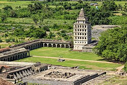
Viluppuram district, also known as Villupuram district or Vizhuppuram district, is one of the 38 districts that make up the state of Tamil Nadu, India. It was founded on 30 September 1993, prior to which it was part of the Cuddalore district. [2] Vizhuppuram district lies in the way of the national highway connecting Tiruchirappalli and Chennai, and contains historical landmarks like the 500 year-old Gingee Fort.