Vikravandi

Last updated

Vikravandi
town
India Tamil Nadu location map.svg
Red pog.svg
Vikravandi
Location in Tamil Nadu, India
Coordinates: 12°02′N79°33′E / 12.03°N 79.55°E / 12.03; 79.55
CountryFlag of India.svg  India
State Tamil Nadu
District Viluppuram
Government
  Typetown
Area
  Total12.22 km2 (4.72 sq mi)
Elevation
44 m (144 ft)
Population
 (2001)
  Total10,449
  Density860/km2 (2,200/sq mi)
Languages
  Official Tamil
Time zone UTC+5:30 (IST)
Vehicle registration TN-32

Vikravandi is a town in Viluppuram district in the Indian state of Tamil Nadu.

Contents

Geography

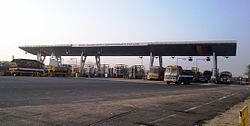
Toll Plaza at Vikravandi GMR-Vikravandi-Toll-Plaza.JPG
Toll Plaza at Vikravandi

Vikravandi is located at 12°02′N79°33′E / 12.03°N 79.55°E / 12.03; 79.55 . [1] It has an average elevation of 44  metres (144  feet). The National Highway NH 132 connects Villupuram and Tindivanam, passes through Vikravandi and NH 36 connects Vikravandi and Manamadurai through Kumbakonam, Thanjavur and Pudukkotai. It is located at the distance of 154 km from Chennai, 14 km from Villupuram and 35 km from Pondicherry.

Demographics

As of 2001 India census, [2] Vikravandi had a population of 10,141. Males constitute 52% of the population and females 48%. Vikravandi has an average literacy rate of 74%, higher than the national average of 59.5%: male literacy is 81%, and female literacy is 66%. In Vikravandi, 10% of the population is under 6 years of age.

Transport

Road

NH 36 connects Vikravandi and Manamadurai via PanrutiNeyveliKumbakonam - Thanjavur - Pudukottai bypasses Villupuram at 5 km in Koliyanur. 

Related Research Articles

<span class="mw-page-title-main">Kumbakonam</span> City Municipal corporation in Tamil Nadu, India

Kumbakonam, or Kudanthai, is a city municipal corporation in the Thanjavur district in the Indian state of Tamil Nadu. It is located 40 km (25 mi) from Thanjavur and 282 km (175 mi) from Chennai and is the headquarters of the Kumbakonam taluk of Thanjavur district. It is the second largest city in the district after Thanjavur. The city is bounded by two rivers, the Kaveri River to the north and Arasalar River to the south. Kumbakonam is known as a "Temple town" due to the prevalence of a number of temples here and is noted for its Mahamaham festival, which happens once in 12 years, attracting people from all over the country.

<span class="mw-page-title-main">Mayiladuthurai</span> Town in Tamil Nadu, India

Mayiladuthurai is a town and district headquarter of Mayiladuthurai district in Tamil Nadu, India. The town is located at a distance of 256 km (159 mi) from the state capital, Chennai.

<span class="mw-page-title-main">Swamimalai</span> Panchayat town/Sub urban in Tamil Nadu, India

Swamimalai is a panchayat town that is a suburb near Kumbakonam in Thanjavur District in the Indian state of Tamil Nadu. It lies on the banks of river Kaveri and is one of the six abodes of the Lord Muruga.

<span class="mw-page-title-main">Thiruvaiyaru</span> Panchayat Town in Tamil Nadu, India

Thiruvaiyaru is a panchayat town in Thanjavur District in the Indian state of Tamil Nadu.

<span class="mw-page-title-main">Siwan, Bihar</span> City in Bihar, India

Siwan is a city and nagar parishad in the Indian state of Bihar. It is the administrative headquarters of Siwan district and one of the urban settlements out of three in the district. It is located close to Uttar Pradesh.

Cholapuram is a panchayat town in the Thanjavur district of the state of Tamil Nadu, India.In ancient time, it's called as Bhairavapuram.

<span class="mw-page-title-main">Jayankondam</span> First Grade Municipality in Tamil Nadu, India

Jayankondam is a First Grade Municipality in Ariyalur district of Tamil Nadu in India. As of 2023, the town had a population of 46,000.

<span class="mw-page-title-main">Lalgudi</span> Town in India

Lalgudi is a town in Tiruchirapalli district in the Indian state of Tamil Nadu. The town of Lalgudi heads the Lalgudi taluk, Lalgudi division, Lalgudi Educational District, Lalgudi DSP and Lalgudi Constituency.

<span class="mw-page-title-main">Papanasam</span> Panchayat Town/Sub urban in Tamil Nadu, India

Papanasam is a panchayat town in Thanjavur district in the Indian state of Tamil Nadu. It is located 25 kilometres (16 mi) from Thanjavur and 15 kilometres (9.3 mi) from Kumbakonam. The name literally translates to "Destruction of Sins" in the Tamil language. It is the suburban region of Kumbakonam.

Thiruppanandal is a panchayat town in Thanjavur district in the Indian state of Tamil Nadu.

Thiruvidaimarudur is a panchayat town in Thanjavur district, in the Indian state of Tamil Nadu. The town is notable for its Mahalingeshwarar Temple, a Hindu shrine for Lord Shiva.

Tindivanam is a town and a municipality in Viluppuram district in the Indian state of Tamil Nadu. It is the second largest town in Villupuram District after the headquarters town Villupuram. Important roads from north to south Tamil Nadu pass through Tindivanam and similarly from west to east.

Valavanur is a panchayat town in Viluppuram district in the Indian state of Tamil Nadu. It is situated near to the Tamil Nadu–Puducherry border on NH 45A.

<span class="mw-page-title-main">Ayyampettai, Thanjavur</span> Panchayat in Tamil Nadu, India

Ayyampettai is a panchayat town in Thanjavur district in the state of Tamil Nadu, India. It is located 15 km from Thanjavur and 24 km from Kumbakonam.

<span class="mw-page-title-main">Viluppuram</span> Place in Tamil Nadu, India

Viluppuram, Villupuram, or Vizhuppuram is a Municipality and the administrative headquarters of Viluppuram district.

Adirampattinam is a newly established Municipality in the Pattukottai taluk of the Thanjavur district in the Indian state of Tamil Nadu. It is also short known by Adirai. It is the largest coastal town in the district and fourth largest town in the Thanjavur district.

Anaikarai is a village panchayat under Thiruvidaimarudur Taluk in Tanjavur district, Tamil Nadu, India. Anaikarai connects with two major bridges. Nearly 1 km long on both sides. It is an island in the basin of Cauvery river. It is located at the distance of 260 km from Chennai and 25 km from Kumbakonam.

<span class="mw-page-title-main">Transport in Thanjavur</span>

Thanjavur has a well-developed transport infrastructure. Thanjavur is well connected by Road, and Rail with most cities and towns in India

Ulundurpettai or Ulundurpet is a municipality in Ulundurpet taluka of Kallakurichi district of Tamil Nadu, India. It is at the intersection of NH 68 and NH 45 located 205 km from Chennai and 129 km from Tiruchirappalli. Ulundurpettai itself is a Constituency for Tamil Nadu State Assembly, and is the Taluk headquarters for Ulundurpet taluka in the eastern region of Kallakurichi district, and is in Ulundurpet revenue block.

<span class="mw-page-title-main">National Highway 36 (India)</span> National highway in India

National Highway 36 is a National Highway in India that starts at Vikravandi and ends at Manamadurai. This highway runs entirely in the state of Tamil Nadu. It has a total length of 334 km.

References

  1. Falling Rain Genomics, Inc - Vikravandi
  2. "Census of India 2001: Data from the 2001 Census, including cities, villages and towns (Provisional)". Census Commission of India. Archived from the original on 16 June 2004. Retrieved 1 November 2008.