Ambuliyar River

Last updated
Ambuliyar River
Ambuliyar River watershed.svg
Drainage basin of the river and its tributaries
India Tamil Nadu relief map.svg
Red pog.svg
Location of the mouth in Tamil Nadu
India relief location map.jpg
Red pog.svg
Ambuliyar River (India)
Location
CountryFlag of India.svg  India
State Tamil Nadu
Districts Pudukkottai, Thanjavur
Taluks Alangudi, Peravurani
Physical characteristics
SourceUnnamed retention basin
  locationAlangudi taluk, Pudukkottai District
  coordinates 10°21′02.8″N79°00′42.8″E / 10.350778°N 79.011889°E / 10.350778; 79.011889
  elevation60 m (200 ft) [1]
Mouth Palk Strait
  location
Peravurani taluk, Thanjavur District
  coordinates
10°13′05″N79°16′49.6″E / 10.21806°N 79.280444°E / 10.21806; 79.280444 Coordinates: 10°13′05″N79°16′49.6″E / 10.21806°N 79.280444°E / 10.21806; 79.280444
  elevation
0 m (0 ft)
Length48 km (30 mi)
Basin size702.58 km2 (271.27 sq mi)
Discharge 
  locationPalk Strait
  average63,800,000 m3/a (2.25×10⁹ cu ft/a)
Basin features
Population307,000
Tributaries 
  leftPunakkutiyar River
  rightMaruthankudiyar River

The Ambuliyar or Ambuli River is a non-perennial river in the Pudukkottai and Thanjavur districts of Tamil Nadu, India, that flows southeast into the Palk Strait.

Contents

Course

The Ambuliyar begins as the outflow of a retention basin east of the town of Alangudi in the Alangudi taluk of Pudukkottai district. From its source the river flows southeast, passing the towns of Vadakadu and Keeramangalam. [2] South of Peravurani, the Ambuliyar is joined on its right bank by the Maruthankudiyar River, its largest tributary, which flows into the Ambuliyar from the west. Almost immediately past this confluence, the Ambuliyar is joined on its left bank by the Punakkuttiyar River, which flows into it from the north. [3] After this confluence, the Ambuliyar flows east until it empties into the Palk Strait south of Kodivayal, forming a small estuary in the Peravurani taluk of Thanjavur district. [4] The river runs for a total length of 48 kilometres (30 mi). [5]

Tributaries

The three main tributaries of the Ambuliyar are the Maruthankudiyar, Punakkuttiyar, and Vellunniyar rivers, which originate in the southwest, northeast, and west of the watershed of the Ambuliyar, respectively. The Vellunniyar joins the Maruthankudiyar at Ramasamypuram, west of where the Maruthankudiyar joins the Ambuliyar. [6]

Basin

The drainage basin of the Ambuliyar is located roughly between the lines of longitude of 79° 0′ E and 79° 10′ E, and the lines of latitude of 10° 10′ N and 10° 20′ N, and covers 702.58 square kilometres (271.27 sq mi) of land in the Pudukkottai and Thanjavur districts of Tamil Nadu. The basin is bordered by the basin of the Vellar River to the south and west, the basin of the Agniyar River to the north, and the Palk Strait to the east. [4] In 2001, about 307,000 people inhabited the basin, [7] in which the largest settlement is Alangudi, which had a population of 12,367 people in 2011. [2]

Geology

Alluvium and pebbly sandstone, along with sand near the coast, are the prominent geological deposits in the river basin. Denudational and fluvial landforms such as pediments, floodplain, and channel fill make up the majority of the central region of the basin. There is tertiary upland and cretaceous lowland in the northwestern part of the basin, and paleotidal flats in the southeastern coastal area. Most of the land in the basin is either barren or used for agriculture. The predominant soil types in the basin are alfisols and vertisols. [7]

Flow and irrigation

Mean annual rainfall in the watershed is 776 millimetres (30.6 in), with a recorded minimum of 156 millimetres (6.1 in) and recorded maximum of 1,108 millimetres (43.6 in). The large majority of this rainfall occurs during the wet season, between June and December. Precipitation levels during the dry season, which typically lasts between January and May, are greatly reduced. Because the reduced level of rainfall usually cannot match heavy irrigative demand, the river does not normally reach the sea during the first half of the year. [6]

6 anicuts cross the river and divert water to 2534 storage tanks and retention basins, and also to numerous irrigation canals and ditches. Water from the Ambuliyar and its tributaries is used to irrigate 469.3 square kilometres (181.2 sq mi) of land, mostly for agriculture. However, despite this heavy demand and lack of flow during the dry season, a five-year study recorded an average discharge at the mouth of the river of 63,800,000 cubic metres (2.25×10⁹ cu ft) of water per year. This could be partly due to supplemental flow from the Kaveri River via the Grand Anicut canal, which stretches from the eastern end of Srirangam Island to where it intersects the course of the Vellar River. Besides meeting the Ambuliyar at two points, the canal also intersects its Vellunniyar and Maruthankudiyar tributaries, along with the nearby Agniyar and Maharajasamundram Rivers. [7]

Related Research Articles

<span class="mw-page-title-main">Kaveri</span> River in southern India

The Kaveri is one of the major Indian rivers flowing through the states of Karnataka and Tamil Nadu. The Kaveri river rises at Talakaveri in the Brahmagiri range in the Western Ghats, Kodagu district of the state of Karnataka, at an elevation of 1,341 m above mean sea level and flows for about 800 km before its outfall into the Bay of Bengal. It reaches the sea in Poompuhar in Mayiladuthurai district. It is the third largest river – after Godavari and Krishna – in southern India, and the largest in the State of Tamil Nadu, which, on its course, bisects the state into north and south. In ancient Tamil literature, the river was also called Ponni.

<span class="mw-page-title-main">Palar River</span> River in southern India

Palar is a river of southern India. It rises in the Nandi Hills in Chikkaballapura district of Karnataka state, and flows 93 kilometres (58 mi) in Karnataka, 33 kilometres (21 mi) in Andhra Pradesh and 222 kilometres (138 mi) in Tamil Nadu before reaching its confluence into the Bay of Bengal at Vayalur about 100 kilometres (62 mi) south of Chennai. It flows as an underground river for a long distance only to emerge near Bethamangala town, from where, gathering water and speed, it flows eastward down the Deccan Plateau. The Towns of Bethamangala, Santhipuram, Kuppam, Ramanaickenpet, Vaniyambadi, Ambur, Melpatti, Gudiyatham, Pallikonda, Anpoondi, Melmonavoor, Vellore, Katpadi, Melvisharam, Arcot, Ranipet, Walajapet, Kanchipuram, Walajabad, Chengalpattu, Kalpakkam, and Lattur are located on the banks of the Palar River. Of the seven tributaries, the chief tributary is the Cheyyar River.

<span class="mw-page-title-main">Pudukkottai</span> Selection-grade municipality in Tamil Nadu, India

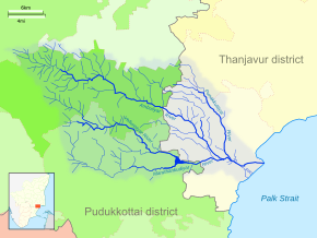
Pudukkottai is the administrative headquarters of Pudukkottai District in the Indian state of Tamil Nadu. It is a large city located on the banks of the Vellar River. It has been ruled, at different times, by the Cholas, Early Pandyas, Thondaimans, and the British. It is situated about 395 kilometres (245 mi) southwest of the state capital Chennai and about 55 kilometres (34 mi) southeast of Tiruchirappalli. Tamil Nadu's first woman Asian Games competitor, Santhi Soundarajan, is from Pudukkottai.

<span class="mw-page-title-main">Nizam Sagar</span> Dam in Telangana, India

Nizam Sagar Dam is an Indian dam named after the Nizam of Hyderabad. It is a reservoir constructed across the Manjira River, a tributary of the Godavari River, between Achampet and BanjePally villages of the Kamareddy district in Telangana, India. It is located at about 144 km (89 mi) north-west of Hyderabad. Nizam Sagar is the oldest dam in the state of Telangana.

<span class="mw-page-title-main">Pudukkottai district</span> District of Tamil Nadu in India

Pudukkottai District is one of the 38 districts of Tamil Nadu state in southern India. The city of Pudukkottai is the district headquarters. It is also known colloquially as Pudhugai.

<span class="mw-page-title-main">Karambakkudi</span> Town in Tamil Nadu, India

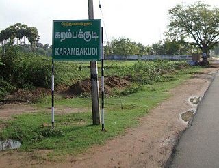
Karambakkudi is a panchayat town as well as Taluk in Pudukkottai district in the Indian state of Tamil Nadu. Karambakkudi is located about 40 km from Thanjavur and 40 km from Pudukkottai. This town is located on the border of the Thanjavur and Pudukkottai district in Tamil Nadu. The opinion of the people of this area is that this area should become an assembly constituency very soon, Here all higher secondary schools and Art's college is there.This area is covered by Delta Region.

Peravurani is a panchayat town in Thanjavur district in the Indian state of Tamil Nadu. It is the administrative headquarters of the Peravurani Taluk and Peravurani. It is declared as Selection Grade Town Panchayat.

<span class="mw-page-title-main">Nagavali River</span> River in India

The River Nagavali also known as Langulya is one of the main rivers of Southern Odisha and North Andhra States in India, between Rushikulya and Godavari basins.

<span class="mw-page-title-main">Vamsadhara River</span> River in India

River Vamsadhara or River Banshadhara is an important east flowing river between Rushikulya and Godavari, in Odisha and Andhra Pradesh states in India.

<span class="mw-page-title-main">Thanjavur district</span> District of Tamil Nadu in India

Thanjavur District is one of the 38 districts of the state of Tamil Nadu, in southeastern India. Its headquarters is Thanjavur. The district is located in the delta of the Cauvery River and is mostly agrarian. As of 2011, Thanjavur district had a population of 2,405,890 with a sex-ratio of 1,035 females for every 1,000 males.

<span class="mw-page-title-main">Vellar River (Northern Tamil Nadu)</span> River in Tamil Nadu, India

The Vellar River is a river in the Indian state of Tamil Nadu. It originates in the Kalrayan Hills, and flows generally eastward through Salem, Perambalur, and Cuddalore districts, before flowing into the Bay of Bengal near Parangipettai. The river has a total length of 150 kilometres (93 mi), and its drainage basin covers an area of 7,504.346 square kilometres (2,897.444 sq mi) in Cuddalore, Perambalur, Salem, Kallakurichi, Ariyalur, Namakkal, Tiruchirappalli, and Dharmapuri districts.

<span class="mw-page-title-main">Upper Anaicut</span> Dam in Tamil Nadu, India

The Upper Anaicut, also known as Mukkombu is a dam built on the Kaveri River in the state of Tamil Nadu in southern India. The regulator dam was constructed between 1836 and 1838 by Sir Arthur Cotton, a British irrigation engineer who was inspired by the architectural beauty of Grand Anaicut canal built by Karikala Chola in Kallanai of Thanjavur district in the second century.

The Koraiyar River is a river in the Ambasamudram taluk of the Tirunelveli district of the Indian state of Tamil Nadu. It is a right-bank tributary of the Thamirabarani River, which flows through Tirunelveli and Thoothukudi districts. It is formed by the confluence of the minor Vadakkur Koraiyar and Therkku Koraiyar rivers, which are its headwater streams, on the eastern slopes of the Western Ghats. It flows for a total length of 13.2 kilometres (8.2 mi) before flowing into the Kannadian channel near the village of Vellankuli upstream of the Kannadian anicut. The channel bypasses the anicut before joining the Thamirabarani downstream and to the east of the dam. Along its course it is joined by three tributaries, the Vandal Odai, Elumichaiyar, and Koppuraiyar rivers. The Koraiyar's drainage basin covers an area of 75.75 square kilometres (29.25 sq mi) and has a recorded maximum flood discharge of 12000 cusecs.

<span class="mw-page-title-main">Kalathur</span> Village in Tamil Nadu, India

Kalathur is a panchayat village in Peravurani panchayat Union of Thanjavur district in the Indian state of Tamil Nadu. Kalathur is a part of the Pattukkottai taluk of Thanjavur district and located 67 kilometres (42 mi) south of Thanjavur connected via State Highway 29.

The Agniyar River is a non-perennial river in the Indian state of Tamil Nadu that flows southeast into the Bay of Bengal.

<span class="mw-page-title-main">Vellar River (Southern Tamil Nadu)</span> River in Tamil Nadu, India

The Vellar River or South Vellar River is a non-perennial river in the Indian state of Tamil Nadu that flows southeast into the Palk Strait, part of the Bay of Bengal.

Belur is a first-grade town panchayat in the Vazhapadi taluk of Salem district, in Tamil Nadu, India.

Kurichi is a village in the Vazhapadi taluk of Salem district, in Tamil Nadu, India.

Singapuram is a village in the Vazhapadi taluk of Salem district, in Tamil Nadu, India.

Vellalakundam is a village in the Vazhapadi taluk of Salem district, in Tamil Nadu, India.

References

  1. "Elevation Map". www.elevationmap.net. Retrieved 2021-02-02.
  2. 1 2 "Pudukkottai District Census Handbook" (PDF). www.censusindia.gov.in. 2011. Retrieved 2021-02-02.
  3. "Thanjavur District Census Handbook" (PDF). www.censusindia.gov.in. 2011. Retrieved 2021-02-02.
  4. 1 2 "Ambuliyar Estuary". www.casmbenvis.nic.in. 2015-01-21. Retrieved 2021-02-02.
  5. "Surface Water Mapping for Watershed Management Using Geospatial Technique". International Journal of Geomatics and Geosciences. 2011-10-01. CiteSeerX   10.1.1.214.8432 .{{cite journal}}: Cite journal requires |journal= (help)
  6. 1 2 "Groundwater Quality Analysis" (PDF). International Journal of Development Research. 2015-08-31. Retrieved 2021-02-02.
  7. 1 2 3 "Agniyar Report" (PDF). nwm.gov.in. Retrieved 2021-02-02.