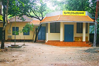
Gram Panchayat is a basic village-governing institute in Indian villages. It is a democratic structure at the grass-roots level in India. It is a political institute, acting as cabinet of the village. The Gram Sabha work as the general body of the Gram Panchayat. The members of the Gram Panchayat are elected by the Gram Sabha.

North 24 Parganas or sometimes North Twenty Four Parganas is a district in southern West Bengal, of eastern India. North 24 Parganas extends in the tropical zone from latitude 22° 11′ 6″ north to 23° 15′ 2″ north and from longitude 88º20' east to 89º5' east. It is bordered to Nadia by north, to Bangladesh by north and east, to South 24 Parganas and Kolkata by south and to Kolkata, Howrah and Hoogly by west. Barasat is the district headquarters of North 24 Parganas. North 24 Parganas is West Bengal's most populous district and also the most populated district in the whole of India. It is the tenth-largest district in the State by area.

South 24 Parganas, or sometimes South Twenty Four Parganas and Dakshin 24 Parganas, is a district in the Indian state of West Bengal, headquartered in Alipore. It is the largest district of West Bengal by area and second largest by population. It is the sixth most populous district in India. On one side of the district there is the urban fringe of Kolkata, and on the other the remote riverine villages in the Sundarbans.

Dakshin Dinajpur or South Dinajpur is a district in the Indian state of West Bengal, India. It was created on 1 April 1992 by the division of the erstwhile West Dinajpur District. The Headquarter (sadar) of the district is at Balurghat. It comprises two subdivisions: Balurghat and Gangarampur. According to the 2011 census, it is the third least populous district of West Bengal.
A sarpanch or Gram Pradhan or Mukhiya is a decision-maker, elected by the village-level constitutional body of local self-government called the Gram Sabha in India. The Sarpanch, together with other elected panchayat members, constitute gram panchayats and zilla panchayats. The sarpanch is the focal point of contact between government officers and the village community and retains power for five years.
Panchayat samiti is a rural local government (panchayat) body at the intermediate tehsil (taluka/mandal) level in India. It works for the villages of the tehsil that together are called a development block. It has been said to be the "panchayat of panchayats".

Panchayati Raj is the system of local self-government of villages in rural India as opposed to urban and suburban municipalities.
A block is an administrative division of some South Asian countries.
Rajendranagar is a mandal in Ranga Reddy district of the Indian state of Telangana. and it is also Rajendranagar revenue division. Rajendranagar is being developed as an IT hub.

Paschim Medinipur district or West Midnapore district is one of the districts of the state of West Bengal, India. It was formed on 1 January 2002 after the Partition of Midnapore into Paschim Medinipur and Purba Medinipur. On 4 April 2017, the Jhargram subdivision was converted into a district. GDP of West Midnapore district is 12 billion USD.

Social forestry is the management and protection of forests and afforestation of barren and deforested lands with the purpose of helping environmental, social and rural development. The term social forestry was first used in 1976 by The National Commission on Agriculture, when the government of India aimed to reduce pressure on forests by planting trees on all unused and fallow lands. It was intended as a democratic approach to forest conservation and usage, maximizing land utilization for multiple purposes.
A tehsil is a local unit of administrative division in some countries of the Indian subcontinent that is usually translated to "township". It is a subdistrict of the area within a district including the designated city, town, hamlet, or other populated place that serves as its administrative centre, with possible additional towns, and usually a number of villages. The terms in India have replaced earlier geographical terms, such as pargana (pergunnah) and thana.
Local government in India refers to governmental jurisdictions below the level of the state. India is a federal republic with three spheres of government: central, state and local. The 73rd and 74th constitutional amendments give recognition and protection to local governments and in addition each state has its own local government legislation. Since 1992, local government in India takes place in two very distinct forms. Urban localities, covered in the 74th amendment to the Constitution, have Nagar Palika but derive their powers from the individual state governments, while the powers of rural localities have been formalized under the panchayati raj system, under the 73rd amendment to the Constitution.

In India, a community development block is a rural area administratively earmarked for planning and development. The area is administered by a Block Development Officer, supported by several technical specialists and village-level workers. A community development block covers several gram panchayats, the local administrative units at the village level.
Elections to Local Bodies in Tamil Nadu are conducted once in five years to elect the representatives to the Urban and Rural local bodies. These elections are conducted by Tamil Nadu State Election Commission
Local bodies in Tamil Nadu constitute the three tier administration set-up in the South Indian state of Tamil Nadu. It is a system of local government which forms the last level from the Centre. Chennai Corporation in the then Madras Presidency, established in 1688, is the oldest such local body not only in India but also in any commonwealth nations outside United Kingdom.
Nalluru is a village in Guntur district of the Indian state of Andhra Pradesh. It is located in Repalle mandal of Tenali revenue division.

The Panchayat raj is a political system, originating from the Indian subcontinent, found mainly in India, Pakistan, Bangladesh, Sri Lanka, and Nepal. It is the oldest system of local government in the Indian subcontinent, and historical mentions date to the 250 CE period. The word raj means "rule" and panchayat means "assembly" (ayat) of five (panch). Traditionally, Panchayats consisted of wise and respected elders chosen and accepted by the local community. These assemblies settled disputes between both individuals and villages. However, there were varying forms of such assemblies.
Silaiman is a panchayat village in Tirupparankunram Mandal (Thiruparankundram) of Madurai District in the Tamil-Nadu state of India. Silaiman is located on the right (south) bank of the Vaigai River, on Route 85 about eight kilometers by road southeast of the city of Madurai, the district headquarters. It is very near to the Keeladi excavation site. Dice made of elephant trunk, ear rings, and thongattan made of gold are examples of the important materials excavated and collected from this site and deposited in Mysore museum. The Tamil Nadu government is taking steps to establish archaeological museums in and around Keeladi village to preserve this kind of material within Tamil Nadu. In the 2011 census the population was 6,436.


